
Solanco School District is a large, rural public school district located in the southern end of Lancaster County, Pennsylvania. Solanco School District encompasses approximately 180 square miles (470 km2). Solanco School District serves: Providence Township, Eden Township, Quarryville Borough, Little Britain Township, Bart Township, Colerain Township, Drumore Township, East Drumore Township and Fulton Township. According to 2008 local census data, it served a resident population of 30,566. By 2010, the district's population increased to 31,871 people. In 2009, the district residents’ per capita income was $17,040, while the median family income was $49,432. In the Commonwealth, the median family income was $49,501 and the United States median family income was $49,445, in 2010.

Tunkhannock Area School District is a midsized rural/suburban public school district serving most of Wyoming County in northeast Pennsylvania in the United States. Tunkhannock Area School District encompasses approximately 397 square miles (1,030 km2). According to 2010 federal census data, Tunkhannock Area School District served a resident population of 28,276. By 2010, the district's population declined sharply to 19,032 people. In 2009, the district residents’ per capita income was $18,112, while the median family income was $44,626. In the Commonwealth, the median family income was $49,501 and the United States median family income was $49,445, in 2010.
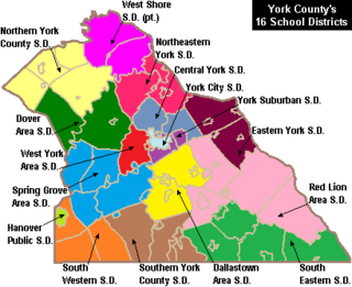
West York Area School District is a midsized, suburban public school district located in York County in South Central Pennsylvania, United States. The West York Area School District includes West York Borough and West Manchester Township. It encompasses approximately 21 square miles (54 km2). According to 2000 federal census data, it served a resident population of 21,356. By 2010, the District's population grew to 23,664 people. In 2009, the District residents’ per capita income was $21,915, while the median family income was $52,309. In the Commonwealth, the median family income was $49,501 and the United States median family income was $49,445, in 2010.

West Branch Area School District is a mid-sized, rural, public school district located in Morrisdale, Clearfield County, and Clinton County, Pennsylvania. The district is one of the 500 public school districts of Pennsylvania. West Branch Area School District was created in 1958 by the joining of Cooper Township High School and Morris Township High School. The district also includes Karthaus Township and Graham Township. The district extends across the Clearfield County's eastern border to include West Keating Township in Clinton County. West Branch Area School District encompasses approximately 165 square miles (430 km2). According to 2000 federal census data, it served a resident population of 7,833. By 2010, the district's population was 7,857 people. The educational attainment levels for the school district population were 85% high school graduates and 9.3% college graduates. In 2009, West Branch Area School District residents' per capita income was $15,055, while the median family income was $37,054 a year. In the Commonwealth, the median family income was $49,501 and the United States median family income was $49,445, in 2010.

Allegheny-Clarion Valley School District (ACVSD) is a small, rural, public school district in western Pennsylvania. It spans portions of four counties and is the only Pennsylvania public school district to do so. The district is one of the 500 public school districts of Pennsylvania. The Allegheny-Clarion Valley School District encompasses approximately 121 square miles (310 km2). In Armstrong County it covers the City of Parker and Hovey Township. In Butler County it serves Allegheny Township. In Clarion County it serves the Boroughs of Emlenton, Foxburg and St. Petersburg and Perry Township and Richland Township. In Venango County it serves the Borough of Emlenton and Richland Township and Scrubgrass Township. According to 2000 federal census data, Allegheny-Clarion Valley School District serves a resident population of 5,944. By 2010, the district's population declined to 5,749 people. In 2009, the district residents' per capita income was $15,525, while the median family income was $36,867. In the Commonwealth of Pennsylvania, the median family income was $49,501 and the United States median family income was $49,445, in 2010. By 2013, the median household income in the United States rose to $52,100.
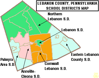
The Palmyra Area School District is the public school system in southwest Lebanon County, Pennsylvania.

The Boyertown Area School District is a large public school district which covers portions of Berks and Montgomery Counties in southeastern Pennsylvania. When the Boyertown Area School District was formed in 1953 it was one of the largest in the state, encompassing 100 square miles (260 km2). In Berks County it covers the Boroughs of Bally, Bechtelsville and Boyertown and Colebrookdale Township, Douglass Township, Earl Township and Washington Township. In Montgomery County it covers Douglass Township, New Hanover Township and Upper Frederick Township.

The Brockway Area School District is a small, rural public school district located in north west Pennsylvania, US. The District encompasses approximately 147 square miles (380 km2) spanning portions of two counties. In Elk County it covers a small portion of Horton Township. In Jefferson County it covers the Borough of Brockway and Polk Township, Snyder Township and Washington Township. The district operates one elementary school and Brockway Area Junior/Senior High School. The district is with the Riverview Intermediate Unit 6 region. The Intermediate Unit provides support services and therapy to special education students. It also provides training to school personnel.

The Bald Eagle Area School District is a midsized, suburban/rural public school district located in Centre County, Pennsylvania. The district serves the Boroughs of Howard, Milesburg, Port Matilda, Snow Shoe and Unionville and Boggs Township, Burnside Township, Howard Township, Huston Township, Snow Shoe Township, Union Township and Worth Township in Centre County, Pennsylvania. Bald Eagle Area School District encompasses approximately 345 square miles (890 km2). According to 2000 federal census data, it serves a resident population of 12,882. By 2010, the district's population increased to 13,218.
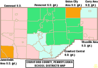
The Crawford Central School District is a midsized, public school district in Crawford County, Pennsylvania. It serves the City of Meadville, Borough of Cochranton and East Fairfield Township, Fairfield Township, Union Township, Vernon Township, Wayne Township and West Mead Township as well as a small portion of Greenwood Township in Crawford County, Pennsylvania, as well as French Creek Township in neighboring Mercer County, Pennsylvania. Crawford Central School District encompasses approximately 156 square miles. According to 2000 federal census data, it serves a resident population of 30,882 people. By 2010, the district's population declined to 30,635 people. In 2009, the Crawford Central School District residents' per capita income was $18,463, while the median family income was $43,771. In the Commonwealth, the median family income was $49,501 and the United States median family income was $49,445, in 2010. By 2013, the median household income in the United States rose to $52,100.

Union Area School District is a diminutive, suburban public school district located in Lawrence County, Pennsylvania. The Union Area School District encompasses approximately 10 square miles (26 km2). The District serves Union Township, Lawrence County, Pennsylvania as well the southeastern portion of Mahoning Township and the independent district of Edinburg which encompasses portions of several neighbouring townships. According to 2000 federal census data, Union Area School District served a resident population of 5,103. In 2010, the population was 5,563 people. In 2009, the district residents’ per capita income was $16,148, while the median family income was $41,086. In the Commonwealth, the median family income was $49,501 and the United States median family income was $49,445, in 2010.

The West Middlesex Area School District is a small, rural public school district serving the southwestern portion of Mercer County, Pennsylvania. It encompasses the communities of West Middlesex, Shenango Township, and Lackawannock Township. The West Middlesex Area School District encompasses approximately 52 square miles (130 km2). The district operates on a single 40-acre campus. According to 2000 federal census data, it served a resident population of 7,527. By 2010, the district's population declined to 7,454 people. In 2009, the district residents’ per capita income was $16,870, while the median family income was $40,558. In the Commonwealth, the median family income was $49,501 and the United States median family income was $49,445, in 2010.

The Upper Dauphin Area School District is a small, rural, public school district located in Dauphin County, Pennsylvania. It is fragmented in four discontinuous pieces, including: the boroughs of Lykens, Elizabethville, Gratz, Berrysburg, and Pillow, as well as Jefferson Township, Washington Township, Mifflin Township, and Lykens Township. Upper Dauphin Area School District encompasses approximately 91 square miles (240 km2). According to 2007 local census data, it serves a resident population of 9,723 people. By 2010, the district's population was 9,759 people. The educational attainment levels for the district's population aged 25 years and over were 81.4% high school graduates and 10.6% college graduates.

The Waynesboro Area School District is a midsized, suburban public school district located in Franklin County, Pennsylvania. The district is one of the 500 public school districts of Pennsylvania. It encompasses the boroughs of Waynesboro and Mont Alto, as well as all of Washington Township and Quincy Township, and a portion of Guilford Township. Waynesboro Area School District encompasses approximately 93 square miles (240 km2). According to 2000 federal census data, it serves a resident population of 28,376. By 2010, the district's population increased to 32,386 people. In 2009, the district residents' per capita income was $18,503, while the median family income was $46,584. In the Commonwealth, the median family income was $49,501 and the United States median family income was $49,445, in 2010.

The Wellsboro Area School District is a small, rural/suburban public school district located in central Tioga County. Wellsboro Area School District encompasses approximately 330 square miles (850 km2). The district serves the borough of Wellsboro and also serves: Middlebury Township, Charleston Township, Delmar Township, Duncan Township, and Shippen Township. Pine Township in Lycoming County, Pennsylvania, which is not connected to the rest of the district, is also served. According to 2000 federal census data, the district served a resident population of 11,689. By 2010, the District's population rose slightly to 11,800 people. The educational attainment levels for the Wellsboro Area School District population were 90.2% high school graduates and 24.3% college graduates. The district is one of the 500 public school districts of Pennsylvania.
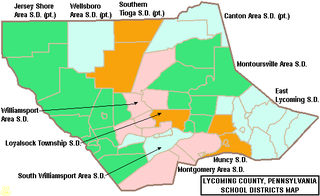
The South Williamsport Area School District is a small public school district in Lycoming County, Pennsylvania, in the United States. The school serves several suburbs of Williamsport, including South Williamsport, DuBoistown, Susquehanna Township, and Armstrong Township. The district encompasses approximately 36 square miles (93 km2). According to 2000 federal census data, it served a resident population of 9,400. By 2010, the district's population declined to 9,268 people. In 2009, the district residents’ per capita income was $18,650, while the median family income was $41,002. In the Commonwealth, the median family income was $49,501 and the United States median family income was $49,445, in 2010. By 2013, the median household income in the United States rose to $52,100.

The Montrose Area School District is a small, rural public school district that is located in northwestern Susquehanna County, Pennsylvania. It serves the following municipalities: Montrose, Bridgewater Township, Franklin Township, Liberty Township, Jessup Township, Forest Lake Township, Silver Lake Township, Little Meadows, Choconut Township, Friendsville, and Middletown Township.
The Northern Tioga School District is a rural public school district operating in Tioga County, Pennsylvania, US. The district serves an extensive rural region, spanning 335 square miles (870 km2) across the northern section of Tioga County. Northern Tioga School District is a third class school district having less than 30,000 residents and is one of the 500 public school districts of Pennsylvania. Municipalities served include: Tioga, Tioga Township, Jackson Township, Lawrenceville, Lawrence Township, Farmington Township, Elkland, Osceola Township, Knoxville, Chatham Township, Deerfield Township, Brookfield, Westfield, and Clymer Township. According to 2000 federal census data, it served a resident population of 14,670. By 2010, the district's population declined to 14,523 people. The educational attainment levels for the Northern Tioga School District population were 85.6% high school graduates and 11.7% college graduates.
South Western School District is a midsized, suburban public school district in York County, Pennsylvania. It serves the townships of Penn Township, Manheim Township and West Manheim Township. It encompasses approximately 56 square miles (150 km2). According to 2000 federal census data, South Western School District serves a resident population of 22,576 people. By 2010, the district's population increased to 26,768 people. In 2009, South Western School District residents’ per capita income was $20,618, while the median family income was $56,296. In the Commonwealth, the median family income was $49,501 and the United States median family income was $49,445, in 2010.
The South Eastern School District is a midsized, rural, public school district in southern York County, Pennsylvania. It serves the boroughs of Cross Roads, Stewartstown, Delta, and Fawn Grove, plus the townships of Hopewell Township, East Hopewell Township, Fawn Township, and Peach Bottom Township. It also includes the villages of Bryansville and Woodbine. The district encompasses approximately 105 square miles (270 km2). According to data from the 2000 federal census, it serves a resident population of 17,884 people. By 2010, South Eastern School District's population increased to 19,567 people. In 2009, the district residents’ per capita income was $20,060, while the median family income was $55,846. In the Commonwealth, the median family income was $49,501 and the United States median family income was $49,445, in 2010.

