Phrygian Way

Last updated

Phrygian Way
Length506 km (314 mi)
Locationwestern Turkey
Established2013;11 years ago (2013)
Trailheads
Use Hiking, Cycling
SightsHistoric Phrygian ruins
Website www.frigyolu.com

The Phrygian Way (Turkish : Frig Yolu) is a marked long-distance hiking and bicycle trail in western Turkey, in part of the ancient Phrygia. [1]

Contents

History

Map of Phrygia with traditional region (yellow) and its maximal expansion (red). Carte Phrygie.png
Map of Phrygia with traditional region (yellow) and its maximal expansion (red).

Phrygia was a kingdom in the classical antiquity, which existed between c. 1200–700 BC and situayed in the west central part of Anatolia, in today's Turkey. The Phrygians, who came to that region from Thrace crossing the Straits, [2] were engaged in agriculture and animal husbandry, in mining and weaving. They produced new musical instruments, developed a unique architecture and built temples and rock-cut tombs. [3] They were one of the dominant powers in Anatolia in the Early Iron Age (9–7th century BC). [2]

Conception and opening

Entrance to the Tomb of Phrygian king Midas in Gordion. Entrance to the Tomb of Midas in Gordion - 2.jpg
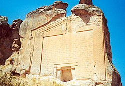
Entrance to the Tomb of Phrygian king Midas in Gordion.
Tomb of King Midas in Midas City. The relief is 17 m (56 ft) high and dates from the 6th century BC. MidasSehri.Tomb.jpg
Tomb of King Midas in Midas City. The relief is 17 m (56 ft) high and dates from the 6th century BC.

The Phrygian Way is located in the valleys between the neighboring provinces of Ankara-Afyonkarahisar-Kütahya-Eskişehir-Uşak-Burdur, based on the roads used by the Phrygians. [2]

Starting from three different places, from Seydiler, İscehisar in Afyonkarahisar, from Yenice Çiftliği in Kütahya, and from Gordion, the political capitol of Phrygia in Polatlı district, Ankara, the routes converge in Phrygian Yazılıkaya or Midas City in Han district of Eskişehir, a Phrtgian religious center. [3] The total length of the Phrygian Way is 506 km (314 mi) making it the third longest hiking trail in Turkey. [1] [4] The Route 1 (in Afyonkarahisar) is 140 km (87 mi) long, the Route 2 (in Kütahya) is 147 km (91 mi) and the Route 3 (in Eskişehir) is 200 km (120 mi) and (in Ankara) 20 km (12 mi). [2]

A project named "Phrygian Cultural Heritage Conservation and Development Union" (Turkish : Frigya Kültürel Mirasını Koruma ve Kalkınma Birliği, FRİGKÜM) was launched to establish the Frygian Way. [2] The trail was completed in 2013 by a team of volunteers, who took part in the project, by combining the existing pathway, ancient ruins and forest roads in the region in an effort of about five years. [5] The trail runs through 44 villages and five town in eight districts of four provinces in the Aegean and Central Anatolia regions of Turkey. The entire route is marked with red and white colors according to international standards. [4] [3] There are 109 poles and 217 direction signs. [2] Informative signposts are placed at 73 places. [4] The starting points of the three routes are indicated by a 2 m × 4 m (6 ft 7 in × 13 ft 1 in)-sized board. [2]

Trails

The trail is named after the Phrygian civilization that ruled around three thousand years ago partly in the region of western and central Anatolia. [6] [7] It consists of three trails, which start at a different place, run from different directions converging in one place situated in a center. The total length of the trails are 506 km (314 mi). [2] The trals are located in the so-called "Phrygian Valleys" offering trekking and cycling opportunities. A guidebook written by the FRİGKÜM Project leader, Hüseyin Sarı, describes the routes with maps. [2]

Route Seydiler – Yazılıkaya

The 140 km (87 mi)-long trail is located in north of Afyonkarahisar Province and partly in southern Eskişehir Province. Starting in Seydiler, it generally runs in northwarts direction through Karakaya, Alanyurt, Selimiye in the İscehisar district, Eskieymir, Ayazini, Göynüş Valley, Demirli, Bayramaliler, Aslantaş-Yılantaş, Döğer, Urumkuş Rocks, Sarıcaova in İhsaniye district, Gökbahçe, Oynaş, Gökçegüney in Seyitgazi district and ends in Yazlıkaya (Midas City).. [2]

Route Yenice Çiftliği – Yazılıkaya

The 147 km (91 mi)-long trail is located in Kütahya Province and partly in southern Eskişehir Province. Starting in Yenice Çiftliği, it runs in southeastwarts direction through Seydiköy, Sabuncupınar, Fındıkköy, Doğluşah, Sökmen, İnli, Yumaklı, Lütfiye villages in Kütahya and Sandiközü, Salihler, Kümbet, Çukurca in Seyitgazi district of Eskişehir Province and ends in Yazılıkaya (Midas City. [2]

Route Yassıhöyük – Yazılıkaya

The approx. 220 km (140 mi)-long trail is located partly in west of Ankara Province and in southern Eskişehir Province. Starting in Yassıhöyük (Gordion), it runs southwestwards through Beylikköprü, Demirci villages in Polatlı district of Amkara Province and Mülk, Nasrettinhoca, Koçaş, İstiklalbağı, Ballıhisar (Pessinus), Ertuğrulköy, Ahiler, Balıkdamı, Kurtşeyh, Buzluca, Gülçayır, Çandır in Sivrihisar district, Ağaçköy, Doğanay, Beyören, Arslanlı in Çifteler district, Başara, Han, Ağlarca Han district of Eskişehir Province and ends in Yazılıkaya (Midas City). [2]

Points of interest

"Rock of the Forty Eyes" in Midas City. The Rock of the Forty Eyes.jpg
"Rock of the Forty Eyes" in Midas City.
Rock-cut Byzantine church in Ayazini AyazinKirche4.jpg
Rock-cut Byzantine church in Ayazini

The region offers geologically interesting formations like fairy chimneys in addition to historic sites with rock-cut dwellings, rock-cut tombs, temples, churches etc. from the eras of Phrygia, Roman Empire, Byzantine Empire, Seljuk Empire and Ottoman Empire. [2] [7]

See also

Books

Related Research Articles

<span class="mw-page-title-main">Çorum Province</span> Province of Turkey

Çorum is a province in the Black Sea Region of Turkey, but lying inland and having more characteristics of Central Anatolia than the Black Sea coast. Its area is 12,428 km2, and its population is 524,130 (2022). Its provincial capital is the city of Çorum, the traffic code is 19.

<span class="mw-page-title-main">Afyonkarahisar Province</span> Province of Turkey

Afyonkarahisar Province, often shortened to Afyon Province, is a province in western Turkey. Its area is 14,016 km2, and its population is 747,555 (2022). The provincial capital is Afyonkarahisar.

<span class="mw-page-title-main">Kütahya Province</span> Province of Turkey

Kütahya Province is a province in the Aegean region of Turkey. Its area is 11,634 km2, and its population is 580,701 (2022). In 1990, Kütahya had a population of 578,000.

<span class="mw-page-title-main">Eskişehir</span> Metropolitan municipality in Central Anatolia, Turkey

Eskişehir is a city in northwestern Turkey and the capital of the Eskişehir Province. The urban population of the city is 898,369 with a metropolitan population of 797,708. The city is located on the banks of the Porsuk River, 792 m above sea level, where it overlooks the fertile Phrygian Valley. In the nearby hills one can find hot springs. The city is 233 km (145 mi) to the west of Ankara, 330 km (205 mi) to the southeast of Istanbul and 78 km (48 mi) to the northeast of Kütahya. It is located in the vicinity of the ancient city of Dorylaeum. Known as a university town; Eskişehir Technical University, Eskişehir Osmangazi University, and Anadolu University are based in Eskişehir. The province covers an area of 2,678 km2 (1,034 sq mi).

<span class="mw-page-title-main">Kütahya</span> City in Turkey

Kütahya is a city in western Turkey which lies on the Porsuk River, at 969 metres above sea level. It is the seat of Kütahya Province and Kütahya District. Its population is 263,863 (2022). The region of Kütahya has large areas of gentle slopes with agricultural land culminating in high mountain ridges to the north and west.

<span class="mw-page-title-main">Polatlı</span> District and municipality in Ankara, Turkey

Polatlı is a municipality and district of Ankara Province, Turkey. Its area is 3,618 km2, and its population is 128,378 (2022). It is 80 km west of the Turkish capital Ankara, on the road to Eskişehir. Its elevation is 853 m.

<span class="mw-page-title-main">Central Anatolia Region</span> Region in Turkey

The Central Anatolia Region is a geographical region of Turkey. The largest city in the region is Ankara. Other big cities are Konya, Kayseri, Eskişehir, Sivas, and Aksaray.

<span class="mw-page-title-main">Battle of Kütahya–Eskişehir</span> 1921 battle of the Turkish War of Independence

The Battle of Kütahya–Eskişehir, was fought between July 10 and July 24, 1921 when the Greek Army of Asia Minor clashed with the Turkish troops commanded by İsmet Pasha in defence of the line of Kara Hisâr-ı Sahib -Kütahya-Eskişehir.

<span class="mw-page-title-main">Phrygia</span> Ancient Anatolian kingdom

In classical antiquity, Phrygia was a kingdom in the west-central part of Anatolia, in what is now Asian Turkey, centered on the Sangarios River. After its conquest, it became a region of the great empires of the time.

<span class="mw-page-title-main">General Directorate of Highways (Turkey)</span> Turkish state agency in charge of public roads

The General Directorate Of Highways (KGM) is a state agency in charge of the construction and maintenance of all public roadways outside of cities and towns in Turkey. It was established on 1 March 1950, following the acceptance of the International Highways Act in 1949. The agency is a sub unit of the Ministry of Transport and Infrastructure.

The Blue Train is the Turkish State Railways premier passenger train service started in the 1980s. The first Blue Train operated between Istanbul and Ankara, entering service in 1979. More Blue Train services were added later on. The İzmir Blue Train, Central Anatolia Blue Train, Çukurova Blue Train and 4th of September Blue Train were are overnight trains. These trains had custom railcars, built by TÜVASAŞ, all painted blue with a blue painted DE 24000 series locomotive pulling the train. The current remnant is just a branding with regular rolling stock. Today there are only three blue trains are in service.

İzmir is a transportation hub for western Anatolia. İzmir has an extensive bus system, a developing metro, commuter rail system and a large urban ferry network. The city has highways connecting it to Çeşme, Menemen, Istanbul, Bursa and Aydın as well as a beltway. Mass transportation is operated by four separate public agencies all owned by the İzmir Municipality.

Selimiye is a settlement in the İscehisar District, Afyonkarahisar Province, Turkey. In 1919 it was called Selimiye but it has also been known as Sarıçayır. By 2007 it was part of the municipality of Alanyurt; in 2012 the population of Selimiye was 179. In 2013 the municipality of Alanyurt was abolished; administratively, Selimiye became part of the village of Alanyurt.

Ayazini is a village in the İhsaniye District, Afyonkarahisar Province, Turkey. Its population is 945 (2021). It is a historical place settled by Phrygians, Ancient Romans, Medieval Greeks and Seljuks. There are dwellings, churches and tomb chambers in rock-cut architecture at the archaeological site.

<span class="mw-page-title-main">Yazılı, Han</span> Phrygian archeological site in Turkey

Yazılı, Phrygian Yazılıkaya, or Midas Kenti is a neighbourhood of the municipality and district of Alpu, Eskişehir Province, Turkey. Its population is 45 (2022). It is located about 27 km south of Seyitgazi, 66 km south of Eskişehir, and 51 km north of Afyonkarahisar. It is known for its Phrygian archaeological remains and inscription mentioning Midas.

<span class="mw-page-title-main">Kümbet, Seyitgazi</span> Neighbourhood in Seyitgazi, Eskişehir, Turkey

Kümbet, is a neighbourhood of the municipality and district of Seyitgazi, Eskişehir Province, Turkey. Its population is 338 (2022).

<span class="mw-page-title-main">Gordion Museum</span>

Gordion Museum is a museum in Turkey.

<span class="mw-page-title-main">Sufi Trail</span>

The Sufi Trail is an 801-kilometre (498 mi) long-distance footpath in Western Turkey from Istanbul to Konya following the Ottoman Sultans Hajj route. The Sufi Trail connects to the Sultans Trail, a long-distance footpath from Vienna to Istanbul. After Konya Sufi Trail connects with the ancient road to Jerusalem and Mecca via the Mecca Trail in Turkey. This route is traditionally used by dwelling dervishes on their way to Konya and further on to Jerusalem and Mecca. In 801 kilometres, the Sufi Trail visits many Sufi saints and passes spiritual, natural and historical highlights. Retracing this journey provides a place of meeting with people of all faiths and cultures.

<span class="mw-page-title-main">İscehisar District</span> District in Afyonkarahisar, Turkey

İscehisar District is a district of Afyonkarahisar Province of Turkey. Its seat is the town İscehisar. Its area is 489 km2, and its population is 24,999 (2021).

Yenice Çiftliği is a hamlet (bağlı) of the Ahmetoluğu village in the Kütahya District of Kütahya Province, Turkey. In September 2022, it was registered as a "Qualified Natural Protection Area" One of the routes of the Phrygian Way, a marked long-distance hiking and bicycle trail, starts at this place.

References

  1. 1 2 "Frig Yolu" (in Turkish). Cultur Routes Society. Retrieved 22 March 2023.
  2. 1 2 3 4 5 6 7 8 9 10 11 12 13 "Frig Yolu Tanıtım" (PDF) (in Turkish). Frig Yolu. Retrieved 22 March 2023.
  3. 1 2 3 "Doğa ve tarihle iç içe yürüyüş rotası: Frig Yolu". NTV (in Turkish). 20 September 2022. Retrieved 23 March 2023.
  4. 1 2 3 Cin, Muharrem (1 May 2018). "Frig Yolu'nda doğa ve tarihle iç içe yolculuk". Anadolu News Agency (in Turkish). Retrieved 22 March 2023.
  5. "Frig Vadisi Üzerinde 3 Bin Yıllık Frig Yolu" (in Turkish). Keşfet TV. 19 October 2022. Retrieved 23 March 2023.
  6. "Yolu antik kentten geçen 6 doğa yürüyüşü rotadı". Cumhuriyet (in Turkish). Retrieved 28 March 2023.
  7. 1 2 Şensoy Boztepe, Ayşe (8 September 2019). "3 bin yıllık tarihi ile Frigya Vadisi yeniden canlanıyor". Anadolu News Agency (in Turkish). Retrieved 28 March 2023.
  8. "Frig Vadisi'ndeki saklı güzellik Seydiler Peri Bacaları". Sözcü (in Turkish). 9 March 2020. Retrieved 28 March 2023.
  9. "İscehisar/Seydiler Kalesi ve Kırkinler Kayalığı" (in Turkish). Kültür ve Turizm Bakanlığı. Retrieved 28 March 2023.
  10. "İscehisar/Sarıçayır (Selimiye) Kayalıkları" (in Turkish). Kültğr ve Turizm Bakanlığı. Retrieved 28 March 2023.
  11. "Ayazini Ören Yeri - Afyonkarahisar" (in Turkish). Türliye Lültür Portalı. Retrieved 28 March 2023.