
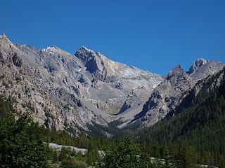
The Dauphiné Alps are a group of mountain ranges in southeastern France, west of the main chain of the Alps. Mountain ranges within the Dauphiné Alps include the Massif des Écrins, Belledonne, the Taillefer range and the mountains of Matheysine.

The Cottian Alps are a mountain range in the southwestern part of the Alps. They form the border between France and Italy (Piedmont). The Fréjus Road Tunnel and Fréjus Rail Tunnel between Modane and Susa are important transportation arteries between France and Italy (Turin).

Hautes-Alpes is a department in the Provence-Alpes-Côte d'Azur region of Southeastern France. It is located in the heart of the French Alps, after which it is named. Hautes-Alpes had a population of 141,107 as of 2016, which makes it the third least populated French department. Its prefecture is Gap; its sole subprefecture is Briançon. Its INSEE and postal code is 05.

Gap is a commune in southeastern France, the prefecture and largest town of the Hautes-Alpes department. At a height of 750 m above sea level, it is France's highest prefecture.

Briançon is the sole subprefecture of the Hautes-Alpes department in the Provence-Alpes-Côte d'Azur region in Southeastern France. It is the highest city in France at an altitude of 1,326 metres, based on the national definition as a community containing more than 2,000 inhabitants. Its most recent population estimate is 11,084 for the commune.
The Queyras is a valley located in the French Hautes-Alpes, of which the geographical extent is the basin of the river Guil, a tributary of the Durance. The Queyras is one of the oldest mountain ranges of the Alps, and it was one of the last ones to be opened to public tourism towards the end of the 20th century, thus being relatively untouched by environmental destruction.

The Ubaye Valley is an area in the Alpes de Haute-Provence département, in the French Alps, having approximately 7,700 residents. Its residents are called Ubayens. Its principal town is the sous-préfecture of Barcelonnette.

Col d'Izoard is a mountain pass in the Alps in the department of Hautes-Alpes in France.

Col du Lautaret is a high mountain pass in the department of Hautes-Alpes in France.

Montgenèvre is a commune on the Italian border in the Hautes-Alpes department in the Provence-Alpes-Côte d'Azur region in Southeastern France. In 2018, it had a population of 456.
Cervières is a commune in the Hautes-Alpes department in southeastern France.
Rochebrune may refer to the following places in France:

Freissinières is a commune in the Hautes-Alpes department in southeastern France.

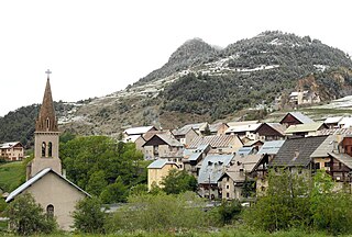
Arvieux is a commune of the Hautes-Alpes department in the Provence-Alpes-Côte d'Azur region of south-eastern France.

The Pic de Rochebrune is a mountain in the Cottian Alps belonging to the French department of Hautes-Alpes.

The Punta Ramiere or Bric Froid is a mountain in the Cottian Alps belonging to the department of Hautes-Alpes (FR) and the province of Turin (IT). It's the highest peak of the long stretch of the Po/Rhone water divide starting from the Aiguille de Scolette (north) and ending with the Monviso group (south).
The Pics de la Font Sancte is a mountain with two summits between the upper Ubaye Valley, Val Escreins and the Ceillac Valley, at the edge of the Queyras Regional Park. It is the highest peak of the Escreins Massif in the southern Cottian Alps in Hautes-Alpes, France. Its northern summit is 3,385 metres (11,106 ft) high and its south summit 3,371 metres (11,060 ft). They take their name from the Font Sancte, a source that springs from the rock in the valley at the foot of the peaks at 2,358 m.

The Punta Merciantaira or Grand Glaiza is a 3,293 metres high mountain of the Cottian Alps.

The Mount Chenaillet is a 2,650 metres high mountain of the Cottian Alps, located on the Main chain of the Alps South of the Col de Montgenèvre.

The Grand Aréa is a 2.869 metres high mountain of the Cottian Alps located in the French department of Hautes-Alpes.


