La Vallée-de-la-Gatineau(The Valley of the Gatineau) is a regional county municipality in the Outaouais region of western Quebec, Canada. The seat is in Gracefield. It was incorporated on January 1, 1983 and was named for its location straddling the Gatineau River north of Low.

Minganie is a regional county municipality in the Côte-Nord region of Quebec, Canada. It includes Anticosti Island. Its seat is Havre-Saint-Pierre.

The term regional county municipality or RCM is used in Quebec to refer to one of 87 county-like political entities. In some older English translations they were called county regional municipality.
The Patapédia River is a tributary of the Restigouche River in Northwest New Brunswick and Southeast Quebec, in Canada.
An unorganized area or unorganized territory is any geographic region in Canada that does not form part of a municipality or Indian reserve. In these areas, the lowest level of government is provincial or territorial. In some of these areas, local service agencies may have some of the responsibilities that would otherwise be covered by municipalities.

Laniel is an unorganized territory in the Témiscamingue Regional County Municipality, Abitibi-Témiscamingue region, Quebec, Canada. It surrounds the northern portion of Lake Kipawa.
The Campbell Branch Little Black River is a short river in Quebec (Canada) and northern Maine.
The West Branch Little Black River is a short river in Quebec and northern Maine.

Lake Lapeyrère is a municipal unorganized territory, part of Portneuf in Quebec, (Canada). The RCM is included in the administrative region of the Capitale-Nationale. This area of the north shore of St. Lawrence river and the west bank of the Batiscan River is located about 75 kilometers northeast of Shawinigan, Quebec. The unorganized territory Lac-Lapeyrère includes Lapeyrère Township, which was established in 1907. The canton is one sector of Portneuf Wildlife Reserve and Zec Tawachiche. Territory Lac-Lapeyrère has several major water bodies including lakes Garneau, Travers, Robinson, Casgrain, Tage and Lapeyrère, and is drained to the east by the Batiscan River.

Lac-Ashuapmushuan is an unorganized territory in the Canadian province of Quebec, Canada, located in the regional county municipality of Le Domaine-du-Roy. The region had a population of 140 as of the Canada 2021 Census, and covered a land area of 14,684.28 km2. It is home to the Ashuapmushuan Wildlife Reserve.
Sault-au-Cochon is an unorganized territory in the Capitale-Nationale region of Quebec, Canada, in the La Côte-de-Beaupré Regional County Municipality. It is an unpopulated and undeveloped stretch of shoreline along the Saint Lawrence River that encompasses the promontory from Cape Tourmente to Petite-Rivière-Saint-François.
Rivière-Nipissis is an unorganized territory in the Côte-Nord region of Quebec, Canada, part of the Sept-Rivières Regional County Municipality.
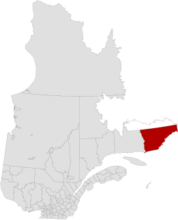
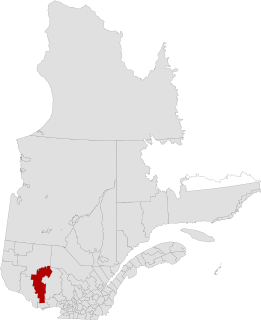
Le Golfe-du-Saint-Laurent is a regional county municipality in the Côte-Nord region of far-eastern Quebec, Canada. It includes all communities along the Gulf of Saint Lawrence between the Natashquan River and the Newfoundland and Labrador border.

Petit-Mécatina is an unorganized territory in the Côte-Nord region of Quebec, Canada, part of Le Golfe-du-Saint-Laurent Regional County Municipality. It was formerly part of the Minganie Regional County Municipality, but transferred to the current MRC in July 2010.

Mont-Alexandre is an unorganized territory in the Gaspésie–Îles-de-la-Madeleine region of Quebec, Canada.

Rivière-Bonjour is an unorganized territory in the Bas-Saint-Laurent region of Quebec, Canada. A large part of the territory is part of the Matane Wildlife Reserve.
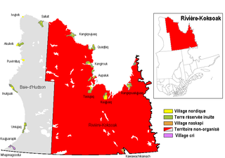
Rivière-Koksoak is a very large unorganized territory in the Kativik Regional Government territory in the Nord-du-Québec region of Quebec. It is named after the Koksoak River.

Lac-Oscar is an unorganized territory in the Laurentides region of Quebec, Canada, and one of eleven unorganized areas in the Antoine-Labelle Regional County Municipality. No permanent population resides in this territory.

Bay Obaoca is an unorganized territory forming part of the Matawinie Regional County Municipality which is part of the administrative region of Lanaudière, in Quebec, in Canada.
The West Branch Pocwock Stream is a tributary of the Pocwock River flowing in:

