Saint-Denis-De La Bouteillerie

Last updated
Saint-Denis-De La Bouteillerie
Saint-Denis-Kamouraska.jpg
Saint-Denis (Bas-Saint-Laurent) Quebec location diagram.png
Location within Kamouraska RCM
Canada Eastern Quebec location map.png
Red pog.svg
Saint-Denis-De La Bouteillerie
Location in eastern Quebec
Coordinates: 47°30′N69°56′W / 47.500°N 69.933°W / 47.500; -69.933 Coordinates: 47°30′N69°56′W / 47.500°N 69.933°W / 47.500; -69.933 [1]
CountryFlag of Canada (Pantone).svg  Canada
Province Flag of Quebec.svg  Quebec
Region Bas-Saint-Laurent
RCM Kamouraska
ConstitutedJuly 1, 1855
Government
[2]
  MayorJean Dallaire
   Federal riding Montmagny—L'Islet—Kamouraska—Rivière-du-Loup
   Prov. riding Côte-du-Sud
Area
  Total97.30 km2 (37.57 sq mi)
  Land33.71 km2 (13.02 sq mi)
Population
 (2011) [3]
  Total503
  Density14.9/km2 (39/sq mi)
  Pop 2006-2011
Decrease2.svg 3.8%
  Dwellings
356
Time zone UTC−5 (EST)
  Summer (DST) UTC−4 (EDT)
Postal code(s)
Area code(s) 418 and 581
HighwaysQc132.svg Route 132
Qc287.svg Route 287
Website www.munstdenis.com

Saint-Denis-De La Bouteillerie is a municipality in the Canadian province of Quebec, located in the Kamouraska Regional County Municipality.

Contents

Prior to November 16, 2013, it was known simply as Saint-Denis and was a parish municipality. The name change was a revival of an old name used from 1845 to 1855. When the name was officially changed, it was also retroactively declared that the name should have been known as Saint-Denis de Kamouraska since 1855. [4]

It contains the house of Jean-Charles Chapais, a National Historic Site of Canada. [5]

See also

Related Research Articles

Jean-Charles Chapais Canadian politician

Jean-Charles Chapais, was a Canadian Conservative politician, and considered a Father of Canadian Confederation for his participation in the Quebec Conference to determine the form of Canada's government.

Rivière-du-Loup City in Quebec, Canada

Rivière-du-Loup is a small city on the south shore of the Saint Lawrence River in Quebec. The city is the seat for the Rivière-du-Loup Regional County Municipality and the judicial district of Kamouraska. Its one of the largest cities in Bas-Saint-Laurent.

Kamouraska Regional County Municipality Regional county municipality in Quebec, Canada

Kamouraska is a regional county municipality in eastern Quebec, Canada. The regional county municipality seat is Saint-Pascal. The other main town is La Pocatière.

La Pocatière City in Quebec, Canada

La Pocatière is a town in the Kamouraska Regional County Municipality in the Bas-Saint-Laurent region of Quebec, Canada.

Rivière-Ouelle Municipality in Quebec, Canada

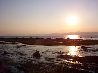
Rivière-Ouelle is a town located in the Kamouraska Regional County Municipality within the Bas-Saint-Laurent region of Quebec. It is located on the Saint Lawrence River; the Ouelle River flows through the town. It was part of the seignory of La Bouteillerie, once owned by Charles Deschamps de Boishébert et de Raffetot. Jean-Charles Chapais, a Father of Canadian Confederation, was born here.

Papineauville, Quebec Municipality in Quebec, Canada

Papineauville is a town and municipality in the Outaouais region of Quebec, Canada. It is the seat of the Papineau Regional County Municipality. In 2001 its population was 2247.

Thomas Chapais

Sir Joseph Amable Thomas Chapais was a French Canadian author, editor, historian, journalist, professor, and politician.

Mont-Carmel, Quebec Municipality in Quebec, Canada

Mont-Carmel is a municipality in the Canadian province of Quebec, located in the Kamouraska Regional County Municipality, on the Canada–United States border.

Saint-Alexandre-de-Kamouraska Municipality in Quebec, Canada

Saint-Alexandre-de-Kamouraska is a municipality in the Canadian province of Quebec, in the Kamouraska Regional County Municipality.

Saint-Bruno-de-Kamouraska Municipality in Quebec, Canada

Saint-Bruno-de-Kamouraska is a municipality in the Canadian province of Quebec, located in the Kamouraska Regional County Municipality.

Saint-Gabriel-Lalemant, Quebec Municipality in Quebec, Canada

Saint-Gabriel-Lalemant is a municipality in the Canadian province of Quebec, located in the Kamouraska Regional County Municipality. The municipality is named for St. Gabriel Lalemant, one of the Canadian Martyrs.

Saint-Pacôme Municipality in Quebec, Canada

Saint-Pacôme is a municipality in the Canadian province of Quebec, located in the Kamouraska Regional County Municipality. Saint-Pacome Catholic Church is located in the town.

Sainte-Hélène-de-Kamouraska Municipality in Quebec, Canada

Sainte-Hélène-de-Kamouraska is a municipality in the Canadian province of Quebec, located in the Kamouraska Regional County Municipality.

Saint-Germain-de-Kamouraska Municipality in Quebec, Canada

Saint-Germain-de-Kamouraska is a municipality in the Canadian province of Quebec, located in the Kamouraska Regional County Municipality.

Saint-Joseph-de-Kamouraska Parish municipality in Quebec, Canada

Saint-Joseph-de-Kamouraska is a parish municipality in the Canadian province of Quebec, located in the Kamouraska Regional County Municipality.

Saint-André-dArgenteuil Municipality in Quebec, Canada

Saint-André-d'Argenteuil is a municipality in the Laurentides region of Quebec, Canada, part of the Argenteuil Regional County Municipality. It is located along the Ottawa River, just south of Lachute.

Saint-Louis-de-Gonzague, Quebec (municipality) Municipality in Quebec, Canada

Saint-Louis-de-Gonzague is a municipality in the Les Etchemins Regional County Municipality in the Chaudière-Appalaches region of Quebec, Canada. Its population is 421 as of the Canada 2011 Census. It lies on the Canada–United States border.

Saint-Hilarion, Quebec Parish municipality in Quebec, Canada

Saint-Hilarion is a parish municipality in Charlevoix Regional County Municipality, in the administrative region of Capitale-Nationale of the province of Quebec, in Canada.

Saint-Pierre-de-lÎle-dOrléans Municipality in Quebec, Canada

Saint-Pierre-de-l'Île-d'Orléans is a municipality in the Capitale-Nationale region of Quebec, Canada, part of the L'Île-d'Orléans Regional County Municipality. It is situated on the west side of Orléans Island, and accessible by Quebec Route 368 and the Île d'Orléans Bridge which connects Saint-Pierre with the Beauport borough of Quebec City. Until 1997, it was known simply as Saint-Pierre.

Saint-Jean-de-lÎle-dOrléans Municipality in Quebec, Canada

Saint-Jean-de-l'Île-d'Orléans is a municipality in the Capitale-Nationale region of Quebec, Canada. It is part of the L'Île-d'Orléans Regional County Municipality, on the southeastern side of Île d'Orléans.

References

  1. Reference number 416348 of the Commission de toponymie du Québec (in French)
  2. 1 2 Geographic code 14055 in the official Répertoire des municipalités (in French)
  3. 1 2 "(Code 2414055) Census Profile". 2011 census . Statistics Canada. 2012.
  4. "Modifications aux municipalités du Québec" (PDF). Institut de la statistique du Québec. 2013. ISSN   1715-6408.
  5. "Chapais House National Historic Site of Canada". www.historicplaces.ca. Retrieved 2022-02-01.