Related Research Articles

The Piedmont is a plateau region located in the Eastern United States. It is situated between the Atlantic coastal plain and the main Appalachian Mountains, stretching from New York in the north to central Alabama in the south. The Piedmont Province is a physiographic province of the larger Appalachian division which consists of the Gettysburg-Newark Lowlands, the Piedmont Upland and the Piedmont Lowlands sections.

The geography of North Carolina falls naturally into three divisions — the Appalachian Mountains in the west, the central Piedmont Plateau, and the eastern Atlantic Coastal Plain. North Carolina covers 53,821 square miles (139,396 km2) and is 503 miles (810 km) long by 150 miles (241 km) wide. The physical characteristics of the state vary from the summits of the Smoky Mountains, an altitude of near seven thousand feet (2,130 m) in the west, sloping eastward to sea level along the coast and beaches of the Atlantic Ocean.
The Northeastern coastal forests are a temperate broadleaf and mixed forests ecoregion of the northeast and middle Atlantic region of the United States. The ecoregion covers an area of 34,630 sq miles (89,691 km2) encompassing the Piedmont and coastal plain of seven states, extending from coastal southwestern Maine, southeastern New Hampshire, eastern Massachusetts, and Rhode Island, southward through Connecticut, New York State, New Jersey, southeast Pennsylvania, Delaware and Maryland.

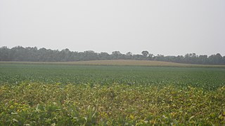
Southeast Georgia's Lower Coastal Plain is a subregion that encompasses the lowest-lying areas of the Atlantic coastal plain in the state, containing barrier islands, marshes, and swampy lowlands, as well as flat plains and low terraces. It differs from Georgia's Upper Coastal Plain in that it is lower in elevation with less relief and wetter soils. The United States Environmental Protection Agency defines the Lower Coastal Plain as an ecoregion, part of the larger, interstate Southern Coastal Plain.

New Jersey is a state within the United States of America that lies on the north eastern edge of the North American continent. It shares a land border with the state of New York along the north, ratified by both states after the New York – New Jersey Line War, which is its only straight line border. New Jersey is slightly larger than the country of Kuwait.

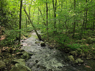
The geology of Georgia consists of four distinct geologic regions, beginning in the northwest corner of the state and moving through the state to the southeast: the Valley and Ridge region, also known as the Appalachian Plateau; the Blue Ridge; the Piedmont and the Coastal Plain. The Fall Line is the boundary between the Piedmont and the Coastal Plain.
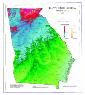
The geography of Georgia describes a state in the Southeastern United States in North America. The Golden Isles of Georgia lie off the coast of the state. The main geographical features include mountains such as the Ridge-and-valley Appalachians in the northwest, the Blue Ridge Mountains in the northeast, the Piedmont plateau in the central portion of the state and Coastal Plain in the south. The highest area in Georgia is Brasstown Bald which is 1,458 m (4,784 ft) above sea level, while the lowest is at sea level, at the Atlantic Ocean. Georgia is located at approximately 33° N 83.5° W. The state has a total area of 154,077 km2 (59,489 sq mi) and the geographic center is located in Twiggs County.

North American Atlantic Region is a floristic region within the Holarctic Kingdom identified by Armen Takhtajan and Robert F. Thorne, spanning from the Atlantic and Gulf coasts to the Great Plains and comprising a major part of the United States and southeastern portions of Canada. It is bordered by the Circumboreal floristic region in the north, by the Rocky Mountain and Madrean floristic regions in the west and by the Caribbean floristic region of the Neotropical Kingdom in the south of Florida. The flora of the region comprises two endemic monotypic families, Hydrastidaceae and Leitneriaceae, and is characterized by about a hundred of endemic genera. The degree of species endemism is very high, many species are Tertiary relicts, which survived the Wisconsin glaciation and are now concentrated in the Appalachians and the Ozarks. A number of genera are shared only with the Canadian floristic province of the Circumboreal region. Moreover, as has long been noted, a large number of relict genera are shared with the relatively distant Eastern Asiatic Region and sometimes Southeast Asia. R. F. Thorne counted at least 74 genera restricted to eastern North America and Asia. The fossil record indicates that during the Tertiary period a warm temperate zone extended across much of the Northern Hemisphere, linking America to Asia.

Barren vegetation describes an area of land where plant growth may be sparse, stunted, and/or contain limited biodiversity. Environmental conditions such as toxic or infertile soil, high winds, coastal salt-spray, and climatic conditions are often key factors in poor plant growth and development. Barren vegetation can be categorized depending on the climate, geology, and geographic location of a specific area.
The Atlantic Maritime Ecozone, as defined by the Commission for Environmental Cooperation (CEC), is an ecozone which covers the Canadian provinces of Prince Edward Island, Nova Scotia, and New Brunswick, as well as the Gaspé Peninsula of Quebec. It is adjacent to the Atlantic Marine Ecozone to the east, and the Mixedwood Plains to the west. The roughly-corresponding Level I Ecoregion to this ecozone in the United States Environmental Protection Agency's classification, which is also part of the CEC system, is the Northern Forests ecoregion, though that classification includes the woodlands and swamps of northern Michigan and Minnesota, which are adjacent to the Boreal Shield ecozone.
The Mann Site is a Crab Orchard culture site located off Indian Mound Road in Mount Vernon, Posey County, Indiana. It was placed on the National Historic Register on October 1, 1974. Exotic ceramics and other artifacts found at the site reflect contact with Ohio Hopewell people, in addition to more distant peoples in the Southeast of the Swift Creek culture of the Georgia Piedmont and Gulf Coastal Plain.

The natural environment of Virginia encompasses the physical geography and biology of the U.S. state of Virginia. Virginia has a total area of 42,774.2 square miles (110,784.67 km2), including 3,180.13 square miles (8,236.5 km2) of water, making it the 35th-largest state by area. Forests cover 65% of the state, wetlands and water cover 6% of the land in the state, while 5% of the state is a mixture of commercial, residential, and transitional.
The Geographical Regions of South Carolina refers to the three major geographical regions of South Carolina: the Appalachian Mountains in the west, the central Piedmont region, and the eastern Atlantic Coastal Plain. The largest region in the state is the Piedmont located between the Mountains and the Carolina Sandhills, while the smallest in region in the state is the Mountains also known as the Blue Ridge Range.

The Southeastern mixed forests are an ecoregion of the temperate broadleaf and mixed forest biome, in the lower portion of the Eastern United States.
The geology of North Carolina includes ancient Proterozoic rocks belonging to the Grenville Province in the Blue Ridge. The region experienced igneous activity and the addition of new terranes and orogeny mountain building events throughout the Paleozoic, followed by the rifting of the Atlantic Ocean and the deposition of thick sediments in the Coastal Plain and offshore waters.

The Northeastern Highlands ecoregion is a Level III ecoregion designated by the United States Environmental Protection Agency (EPA) in the U.S. states of Vermont, New Hampshire, Massachusetts, Maine, Connecticut, New York, New Jersey, and Pennsylvania. The ecoregion extends from the northern tip of Maine and runs south along the Appalachian Mountain Range into eastern Pennsylvania. Discontiguous sections are located among New York's Adirondack Mountains and the Catskill Range. The largest portion of the Northeastern Highlands ecoregion encompasses several sub mountain ranges including the Berkshires, Green Mountains, Taconic, and White Mountains.
References
- https://www.sciencebase.gov/catalog/item/55c77fc4e4b08400b1fd8350 (public-domain origin of the text in this article)