Arkansas Valley (ecoregion)

Last updated
Arkansas Valley ecoregion
Mt. Magazine State Park 026.jpg
View from Mount Magazine, the highest point in Arkansas, looking down upon the low valleys and hills of the Arkansas Valley
Arkansas Valley ecoregion, Level III.png
Level III ecoregions in the region, with the Arkansas Valley ecoregion marked as (37) (full map)
Ecology
Borders
Geography
Area28,422 km2 (10,974 sq mi)
CountryUnited States
StatesArkansas and Oklahoma
Climate type Humid subtropical (Cwa)

The Arkansas Valley is a Level III ecoregion designated by the Environmental Protection Agency (EPA) in the U.S. states of Arkansas and Oklahoma. It parallels the Arkansas River between the flat plains of western Oklahoma and the Arkansas Delta, dividing the Ozarks and the Ouachita Mountains with the broad valleys created by the river's floodplain, occasionally interrupted by low hills, scattered ridges, and mountains. In Arkansas, the region is often known as the Arkansas River Valley (or just River Valley), especially when describing the history and culture of the region.

Contents

Arkansas Valley is a synclinal and alluvial valley lying between the Ozark Highlands and the Ouachita Mountains. The Arkansas Valley is, characteristically, diverse and transitional. It generally coincides with the Arkoma Basin, an oil and gas province, that developed as sand and mud were deposited in a depression north of the rising Ouachita Mountains during the Mississippian and Pennsylvanian eras. The Arkansas Valley contains plains, hills, floodplains, terraces, and scattered mountains. It is largely underlain by interbedded Pennsylvanian sandstone, shale, and siltstone. Prior to the 19th century, uplands were dominated by a mix of forest, woodland, savanna, and prairie whereas floodplains and lower terraces were covered by bottomland deciduous forest. Today, less rugged upland areas have been cleared for pastureland or hayland. Poultry and livestock farming are important land uses. Water quality is generally good and influenced more by land use activities than by soils or geology; average stream gradients and dissolved oxygen levels are lower in the Arkansas Valley than in the Ouachita Mountains or Ozark Highlands, whereas turbidity, total suspended solids, total organic carbon, total phosphorus, and biochemical oxygen demand values are typically higher. The Arkansas River is continuously turbid. Summer flow in smaller streams is typically limited or nonexistent. Fish communities characteristically contain a substantial proportion of sensitive species; a sunfish- and minnowdominated community exists along with substantial proportions of darters and catfishes (particularly madtoms).

The Arkansas Valley ecoregion has been subdivided into five Level IV ecoregions. [1] [2]

Level IV ecoregions

Level IV ecoregions in the Arkansas Valley in Arkansas and Oklahoma. Level IV ecoregions, Arkansas Valley.png
Level IV ecoregions in the Arkansas Valley in Arkansas and Oklahoma.

Scattered High Ridges and Mountains (37a)

The Scattered High Ridges and Mountains ecoregion is the most rugged and wooded in the Arkansas Valley. The ecoregion is characteristically covered by savannas, open woodlands, or forests dominated or codominated by upland oaks, hickory, and shortleaf pine; loblolly pine occurs but is not native. It is underlain by Pennsylvanian sandstone and shale; calcareous rocks such as those that dominate the Ozark Highlands are absent. Nutrient and mineral values (including turbidity and hardness) in streams are slightly higher than in other parts of the Arkansas Valley. Magazine Mountain, the highest point in Arkansas at 2,753 feet, is distinguished by diverse habitats. Its flat top is covered with xeric, stunted woodlands. Mesic habitats also occur and may contain beech–maple forests. The region covers 895 square miles (2,320 km2) in Arkansas and 383 square miles (990 km2) in Oklahoma. [3] Public lands include the Poteau Mountain Wilderness and the Dry Creek Wilderness, bordering the Fourche Mountains in the Ouachita National Forest. Mount Magazine State Park, Mount Nebo State Park, and Petit Jean State Park represent protected mountains scattered through the gentler plains and floodplains of the Arkansas Valley.

Arkansas River Floodplain (37b)

The Arkansas River Floodplain ecoregion is characteristically veneered with Holocene alluvium and includes natural levees, meander scars, oxbow lakes, point bars, swales, and backswamps. It is lithologically and physiographically distinct from the surrounding uplands of the Arkansas Valley. Mollisols, Entisols, Alfisols, and Inceptisols are common; the soil mosaic sharply contrasts with nearby, higher elevation ecoregions where Ultisols developed under upland oaks, hickory, and pine. Potential natural vegetation is southern floodplain forest. Bottomland oaks including bur oak, American sycamore, sweetgum, willows, eastern cottonwood, green ash, pecan, hackberry, and elm were once extensive. They have been widely cleared for pastureland, hayland, and cropland. However, some forest remains in frequently flooded or poorly-drained areas. In Arkansas, bur oak is most dominant in ecoregion 37b. The region covers 415 square miles (1,070 km2) in Arkansas and 135 square miles (350 km2) in Oklahoma. [3]

A large section of preserved ecoregion is within Holla Bend National Wildlife Refuge and Galla Creek Wildlife Management Area in southern Pope County, Arkansas. Near Central Arkansas, Bell Slough Wildlife Management Area, a 2,040 acres (830 ha) outcropping of Arkansas River Floodplain wedged between a mountainous section. Bell Slough WMA is home to the moist-soil wetlands, bottomland hardwood forest, and prairie attractive to migratory waterfowl along the Mississippi Flyway, as well as upland hardwood and pine forest in a transition zone toward the upland mountains.

Arkansas Valley Hills (37c)

The Arkansas Valley Hills ecoregion is underlain by Pennsylvanian sandstone and shale, and is lithologically distinct from Ecoregions 37b and 39. Ecoregion 37c is more hilly than the Arkansas Valley Plains (37d) and less rugged than Ecoregions 36, 37a, and 38. Ultisols are common and support a potential natural vegetation of oak–hickory forest or oak–hickory–pine forest; both soils and natural vegetation contrast with those of Ecoregion 37b. Today, pastureland is extensive, but rugged areas are wooded; overall, trees are much less extensive than in neighboring Ecoregions 36d, 37a, and 38 but more widespread than in Ecoregions 37b and 37d. Poultry operations, livestock farming, and logging are important land uses. The region covers 2,771 square miles (7,180 km2), entirely within Arkansas. [3] Preserved examples of the ecoregion include Cove Creek Natural Area and Woolly Hollow State Park in Faulkner County and Big Creek Natural Area in Cleburne County.

Arkansas Valley Plains (37d)

The Arkansas Valley Plains ecoregion is in the rainshadow of the Fourche Mountains and was once covered by a distinctive mosaic of prairie, savanna, and woodland. Ecoregion 37d is mostly undulating but a few hills and ridges occur. Westward, Ecoregion 37d becomes flatter, drier, more open, and has fewer topographic fire barriers. Prior to the 19th century, frequently burned western areas had extensive prairie on droughty soils; scattered pine–oak savanna also occurred. Elsewhere, potential natural vegetation is primarily oak–hickory forest or oak–hickory–pine forest. Today, pastureland and hayland are extensive but remnants of prairie, particularly the Cherokee Prairie near Fort Smith, and woodland occur. Poultry and livestock farming are primary land uses. Cropland agriculture in the Arkansas Valley Plains is less important than in Ecoregion 37b, and wooded areas are not as extensive as in more rugged Ecoregions 36, 37a, 37c, and 38. Stream turbidity generally remains low except during storm events. The region covers 2,084 square miles (5,400 km2) in Arkansas and 1,655 square miles (4,290 km2) in Oklahoma. [3]

Small remnants of this ecoregion are preserved in Arkansas, including Cherokee Prairie Natural Area and H.E. Flanagan Natural Area in southern Franklin County, Arkansas, and Petit Jean River Wildlife Management Area and Ed Gordon Point Remove Wildlife Management Area.

Lower Canadian Hills (37e)

The Lower Canadian Hills ecoregion is underlain by Pennsylvanian-age shale, sandstone, and coal. It acts as a transition between the drier Cross Timbers to the west and moister parts of the Arkansas Valley to the east. Native vegetation is a mixture of oak woodland, tallgrass prairie, oak–hickory forest, and oak–hickory–pine forest. In general, wooded hills are more widespread than in the nearby Arkansas Valley Plains and Osage Cuestas. Prairies become more extensive in ecoregions to the west. Streams tend to have deeper pools and more habitat diversity than in the Northern Cross Timbers. Fish and macroinvertebrate species richness is greater than in the Cross Timbers, but less than in the rest of the Arkansas Valley. The ecoregion covers 2,635 square miles (6,820 km2), entirely within Oklahoma. [3]

Landscapes

See also

Related Research Articles

Ouachita National Forest American forest

The Ouachita National Forest is a vast congressionally-designated National Forest that lies in the western portion of Arkansas and portions of extreme-eastern Oklahoma, USA.

Boston Mountains Highland ecoregion in Arkansas and Oklahoma, United States

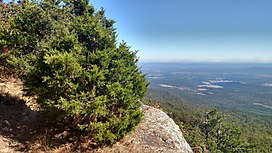
The Boston Mountains is a Level III ecoregion designated by the Environmental Protection Agency (EPA) in the U.S. states of Arkansas and Oklahoma. Part of the Ozarks, the Boston Mountains are a deeply dissected plateau. The ecoregion is steeper than the adjacent Springfield Plateau to the north, and bordered on the south by the Arkansas Valley. The Oklahoma portion of the range is locally referred to as the Cookson Hills.

Ouachita Mountains Mountain range in Arkansas and Oklahoma, United States

The Ouachita Mountains, simply referred to as the Ouachitas, are a mountain range in western Arkansas and southeastern Oklahoma. They are formed by a thick succession of highly deformed Paleozoic strata constituting the Ouachita Fold and Thrust Belt, one of the important orogenic belts of North America. The Ouachitas continue in the subsurface to the northeast, where they make a poorly understood connection with the Appalachians and to the southwest, where they join with the Marathon uplift area of West Texas. Together with the Ozark Plateaus, the Ouachitas form the U.S. Interior Highlands. The highest natural point is Mount Magazine at 2,753 feet.

Western Upland

The Western Upland is a geographical region covering much of the western half of the U.S. state of Wisconsin. It stretches from southern Polk County, Wisconsin in the north to the state border with Illinois in the south, and from Rock County in the east to the Mississippi River in the west.

Cross Timbers Ecoregion in Texas, Oklahoma, and Kansas

The term Cross Timbers, also known as Ecoregion 29, Central Oklahoma/Texas Plains, is used to describe a strip of land in the United States that runs from southeastern Kansas across Central Oklahoma to Central Texas. Made up of a mix of prairie, savanna, and woodland, it forms part of the boundary between the more heavily forested eastern country and the almost treeless Great Plains, and also marks the western habitat limit of many mammals and insects.

Appalachian mixed mesophytic forests Temperate broadleaf and mixed forests ecoregion of the United States

The Appalachian mixed mesophytic forests is an ecoregion of the temperate broadleaf and mixed forests biome, as defined by the World Wildlife Fund. It consists of mesophytic plants west of the Appalachian Mountains in the Southeastern United States.

Osage Plains Physiographic section extending through five U.S. states

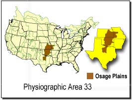
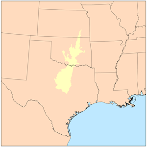
The Osage Plains are a physiographic section of the larger Central Lowland province, which in turn is part of the larger Interior Plains physiographic division. The area is sometimes called the Lower Plains, North Central Plains,or Rolling Plains. The Osage Plains, covering west-central Missouri, the southeastern third of Kansas, most of central Oklahoma, and extending into north-central Texas, is the southernmost of three tallgrass prairie physiographic areas. It grades into savanna and woodland to the east and south, and into shorter, mixed-grass prairie to the west. The Osage Plains consist of three subregions. The Osage Plains proper occupy the northeast segment. Although sharply demarcated from the Ozark uplift, the plains are nonetheless a transitional area across which the boundary between prairie and woodland has shifted over time. In the central portion of the physiographic area lies the second subregion, the Flint Hills, commonly called "the Osage" in Oklahoma. This large remnant core of native tallgrass prairie is a rocky rolling terrain that runs from north to south across Kansas and extends into Oklahoma. To the west and south of these hills are the Blackland Prairies and Cross Timbers. This vegetatively complex region of intermixed prairie and scrubby juniper-mesquite woodland extends into north-central Texas. Bluestem prairies and oak-dominated savannas and woodlands characterize the natural vegetation in the Cross Timbers. Much of the area has been converted to agriculture, although expanses of oak forest and woodland are still scattered throughout the eastern portion of the subregion.

Geography of Oklahoma

The Geography of Oklahoma encompasses terrain and ecosystems ranging from arid plains to subtropical forests and mountains. Oklahoma contains 10 distinct ecological regions, more per square mile than in any other state by a wide margin. It is situated in the Great Plains and U.S. Interior Highlands region near the geographical center of the 48 contiguous states. Usually considered part of the South Central United States, Oklahoma is bounded on the east by Arkansas and Missouri, on the north by Kansas, on the northwest by Colorado, on the far west by New Mexico, and on the south and near-west by Texas.

Geography of Arkansas

The geography of Arkansas varies widely. The state is covered by mountains, river valleys, forests, lakes, and bayous in addition to the cities of Arkansas. Hot Springs National Park features bubbling springs of hot water, formerly sought across the country for their healing properties. Crowley's Ridge is a geological anomaly rising above the surrounding lowlands of the Mississippi embayment.

Snake River Plain (ecoregion)

The Snake River Plain ecoregion is a Level III ecoregion designated by the United States Environmental Protection Agency (EPA) in the U.S. states of Idaho and Oregon. It follows the Snake River across Idaho, stretching roughly 400 miles (640 km) from the Wyoming border to Eastern Oregon in the xeric intermontane west. Characterized by plains and low hills, it is considerably lower and less rugged than surrounding ecoregions. Many of the alluvial valleys bordering the Snake River are used for agriculture. Where irrigation water and soil depth are sufficient, sugar beets, potatoes, alfalfa, small grains, and vegetables are grown. Elsewhere, livestock grazing is widespread. Cattle feedlots and dairy operations are found locally.

Klamath Mountains (ecoregion) Temperate coniferous forests ecoregion in northern California and southwestern Oregon

The Klamath Mountains ecoregion of Oregon and California lies inland and north of the Coast Range ecoregion, extending from the Umpqua River in the north to the Sacramento Valley in the south. It encompasses the highly dissected ridges, foothills, and valleys of the Klamath and Siskiyou Mountains. It corresponds to the Level III ecoregion designated by the Environmental Protection Agency and to the Klamath-Siskiyou forests ecoregion designated by the World Wide Fund for Nature.

Ozark Highlands (ecoregion)

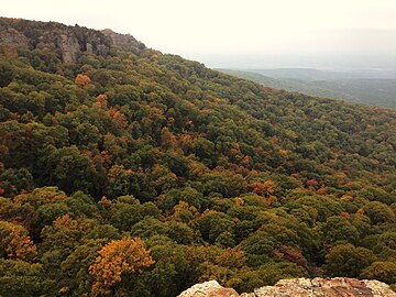
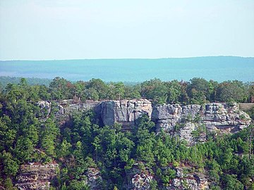
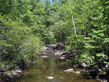
The Ozark Highlands is a Level III ecoregion designated by the Environmental Protection Agency (EPA) in four U.S. states. Most of the region is within Missouri, with a part in Arkansas and small sections in Oklahoma and Kansas. It is the largest subdivision of the region known as the Ozark Mountains, less rugged in comparison to the Boston Mountains in Arkansas, the highest part of the Ozarks.

Mississippi lowland forests Temperate broadleaf and mixed forests ecoregion of the United States

The Mississippi lowland forests are a temperate broadleaf and mixed forest ecoregion in the eastern United States, covering an area of 112,300 km2 (43,400 sq mi).

East Central Texas forests Temperate broadleaf and mixed forests ecoregion of Oklahoma and Texas, United States

The East Central Texas forests (33) is a small temperate broadleaf and mixed forests ecoregion almost entirely within the state of Texas, United States. The northern forests perimeter is partially within the southeast Oklahoma border.

Interior Low Plateaus

The Interior Low Plateaus are a physiographic region in eastern United States. It consists of a diverse landscape that extends from north Alabama across central Tennessee and Kentucky into southern Illinois, Indiana, and Ohio. Its natural communities are a matrix of temperate forests, woodlands, and prairies.

Southeastern conifer forests Temperate coniferous forests ecoregion of the United States

The Southeastern conifer forests are a temperate coniferous forest ecoregion of the southeastern United States. It is the largest conifer forest ecoregion east of the Mississippi River. It is also the southernmost instance of temperate coniferous forest within the Nearctic realm.

Mississippi Alluvial Plain (ecoregion) Ecoregion in the southern United States

The Mississippi Alluvial Plain is a Level III ecoregion designated by the Environmental Protection Agency (EPA) in seven U.S. states, though predominantly in Arkansas, Louisiana, and Mississippi. It parallels the Mississippi River from the Midwestern United States to the Gulf of Mexico.

Western Corn Belt Plains

The Western Corn Belt Plains is a Level III ecoregion designated by the Environmental Protection Agency (EPA) in seven U.S. states, though predominantly in Iowa.

References

  1. PD-icon.svg This article incorporates  public domain material from the United States Geological Survey document: Woods, A.J.; Foti, T.L.; Chapman, S.S.; Omernik, J.M.; et al. "Ecoregions of Arkansas" (PDF).(color poster with map, descriptive text, summary tables, and photographs)
  2. PD-icon.svg This article incorporates  public domain material from the United States Geological Survey document: Woods, A.J.; Omernik, J.M.; Butler, D.R.; Ford, J.G.; et al. "Ecoregions of Oklahoma" (PDF). Retrieved January 18, 2018.(color poster with map, descriptive text, summary tables, and photographs)
  3. 1 2 3 4 5 PD-icon.svg This article incorporates  public domain material from the United States Environmental Protection Agency document: "US Level IV Ecoregions shapefile with state boundaries (SHP file)" . Retrieved January 18, 2018.