
Yell County is a county in the U.S. state of Arkansas. As of the 2020 census, the population was 20,263. The county has two county seats, Dardanelle and Danville. Yell County is Arkansas's 42nd county, formed on December 5, 1840, from portions of Scott and Pope counties. It was named after Archibald Yell, who was the state's first member of the United States House of Representatives and the second governor of Arkansas. He died in combat at the Battle of Buena Vista during the Mexican–American War.
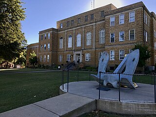
Faulkner County is a county located in the Central Arkansas region of the U.S. state of Arkansas. As of the 2020 census, the population was 123,498, making it the fifth most populous of Arkansas's 75 counties. The county seat and largest city is Conway. Faulkner County was created on April 12, 1873, one of nine counties formed during Reconstruction, and is named for Sandford C. Faulkner, better known as Sandy Faulkner, a popular figure in the state at the time.

Greenbrier is a city in Faulkner County, Arkansas, United States. It is part of the Central Arkansas region. The population was 5,707 at the 2020 census, up from 4,706 at the 2010 census.

Dwight Presbyterian Mission was one of the first American missions to the Native Americans. It was established near present-day Russellville, Arkansas in 1820 to serve the Arkansas Cherokees. After the Cherokee were required to move to Indian Territory in 1828, the mission was reestablished in 1829 near present-day Marble City, Oklahoma. The mission is listed on the National Register of Historic Places.

Central Arkansas, also known as the Little Rock metro, designated by the United States Office of Management and Budget as the Little Rock-North Little Rock-Conway Metropolitan Statistical Area, is the most populous metro area in the U.S. state of Arkansas. With an estimated 2020 population of 748,031, it is the most populated area in Arkansas. Located at the convergence of Arkansas's other geographic regions, the region's central location make Central Arkansas an important population, economic, education, and political center in Arkansas and the South. Little Rock is the state's capital and largest city, and the city is also home to two Fortune 500 companies, Arkansas Children's Hospital, and University of Arkansas for Medical Sciences (UAMS).

New Echota was the capital of the Cherokee Nation in the Southeastern United States from 1825 until their forced removal in the late 1830s. New Echota is located in present-day Gordon County, in northwest Georgia, north of Calhoun. It is south of Resaca, next to present day New Town, known to the Cherokee as Ꭴꮝꮤꮎꮅ, Ustanali. The site has been preserved as a state park and a historic site. It was designated in 1973 as a National Historic Landmark District.

Fort Smith National Historic Site is a National Historic Site located in Fort Smith, Arkansas, along the Arkansas River. The first fort at this site was established by the United States in 1817, before this area was established as part of Indian Territory. It was later replaced and the second fort was operated by the US until 1871. This site was designated as a National Historic Landmark in 1961.
Willstown was an important Cherokee town of the late 18th and early 19th century, located in the southwesternmost part of the Cherokee Nation, in what is now DeKalb County, Alabama. It was near Lookout or Little Wills Creek. It was in Wills Valley, which also incorporated Big Wills Creek. This was within the territory of the Lower Creek, who had crossed into this area in an effort to avoid European-American encroachment.

Fort Gibson is a historic military site next to the modern city of Fort Gibson, in Muskogee County Oklahoma. It guarded the American frontier in Indian Territory from 1824 to 1888. When it was constructed, the fort was farther west than any other military post in the United States. It formed part of the north–south chain of forts that was intended to maintain peace on the frontier of the American West and to protect the southwestern border of the Louisiana Purchase. The fort succeeded in its peacekeeping mission for more than 50 years, as no massacres or battles occurred there.

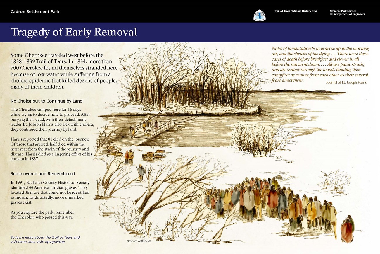
Highway 319 is a designation for two state highways in central Arkansas. The main segment runs 18.01 miles (28.98 km) from AR 38 in Ward to AR 107 south of Vilonia. A short segment runs 1.65 miles (2.66 km) from Cadron Settlement Park to US 64 in Conway.

The Tellico Blockhouse was an early American outpost located along the Little Tennessee River in what developed as Vonore, Monroe County, Tennessee. Completed in 1794, the blockhouse was a US military outpost that operated until 1807; the garrison was intended to keep peace between the nearby Overhill Cherokee towns and encroaching early Euro-American pioneers in the area in the wake of the Cherokee–American wars.
Jesse Bushyhead was a Cherokee religious and political leader, and a Baptist minister. He was born near the present-day town of Cleveland, Tennessee. As a young man, he was ordained a Baptist minister.

Norristown was a 19th-century town and trading center on the Arkansas River and, later, an incorporated town on Norristown Mountain in Illinois Township, Pope County, Arkansas, United States. The town merged with Russellville on August 14, 1980.

Fitzgerald Station and Farmstead is a collection of historic buildings and structures in Springdale, Arkansas associated with the Butterfield Overland Mail Trail. Historically the site of a tavern popular with travelers heading west prior to the establishment of the Butterfield Trail, the property became a station along the route in the 1850s. Today, the property retains an original 1850s barn built as a waypoint along the route, as well as an 1870s house and associated outbuildings. It was listed on the National Register of Historic Places in May 2003.
The Military Road-Cadron Segment is a portion of 19th-century roadway in Faulkner County, Arkansas, near the city of Conway. It consists of an original section of a military road built in the mid-1830s between Little Rock and the military outpost at Fort Smith, through what was then frontier territory. It is one of the only known surviving sections of the early military roads that crossed the Arkansas Territory, which is located west of Little Rock. The road is further notable as one of the routes by which Native Americans were relocated to Indian Territory from points east of the Mississippi River.
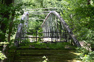
The Springfield Bridge is a historic bowstring truss bridge, located in Beaverfork Lake Park in Conway, Arkansas, USA. It originally spanned Cadron Creek in rural Faulkner County east of Springfield. It is 188 feet (57 m) long, set on stone abutments, with tubular metal top chords that rise 15 feet (4.6 m) above the bottom chords. Built circa 1871–74, it is the oldest documented highway bridge in the state and its only documented bowstring arch bridge.

The Titan II ICBM Launch Complex 374-5 Site is a historic military installation in rural Faulkner County, Arkansas. It is located roughly midway between Greenbrier and Conway, on the east side of United States Route 65 about 0.4 miles (0.64 km) north of its junction with East Cadron Ridge Road. It is an underground complex on 10 acres (4.0 ha) of land, featuring a missile silo and launch control facility. Its ground-level access points have been back-filled with rubble or welded shut, and are discernible only by the presence of concrete pads and mounds of earth. Surface features also include the remnants of a helicopter pad and a theodolite siting marker, and the original access road to the facility from US 65. The facility was staffed by the 374th Strategic Missile Squadron between 1963 and 1986, housing an LGM-25C Titan II ICBM, and was decommissioned and rendered non-functional in 1987 under the terms of the SALT II strategic arms treaty.
The Memphis to Little Rock Road was a settlement road constructed between 1819 and Reconstruction in Arkansas. The project was one of many internal improvements to assist settlement of the Old Southwest as well as military defense of the Arkansas Territory.

The historic Cherokee settlements were Cherokee settlements established in Southeastern North America up to the removals of the early 19th century. Several settlements had existed prior to and were initially contacted by explorers and colonists of the colonial powers as they made inroads into frontier areas. Others were established later.

Blockhouse on Signal Mountain is within the Fort Sill Military Reservation, north of Lawton, Oklahoma. The rock architecture is located along Mackenzie Hill Road at the summit of Signal Mountain within the Fort Sill West Range being the Oklahoma administrative division of Comanche County.


