The Orthodox Church of Finland is an autonomous Eastern Orthodox archdiocese of the Ecumenical Patriarchate of Constantinople. The church has a legal position as a national church in the country, along with the Evangelical Lutheran Church of Finland.

Alajärvi is a town and municipality of Finland. It is located in the South Ostrobothnia region. The town has a population of 9,321 and covers an area of 1,056.74 square kilometres (408.01 sq mi) of which 47.99 km2 (18.53 sq mi) is water. The population density is 9.24 inhabitants per square kilometre (23.9/sq mi). The town is unilingually Finnish; there are few immigrants.
Jämsänkoski is a former town and municipality of Finland in the Central Finland region. It is located near Lake Päijänne and the Jämsänjoki river. The town had a population of 7,351 in 2008. It covered an area of 448.67 km² of which 48.02 km² is water. The population density was 16.9 inhabitants per km².
Vihti is a small municipality located in the Uusimaa region of province of Southern Finland, approximately 50 kilometres (30 mi) northwest of the capital city Helsinki. The municipality has a population of 29,241 and covers an area of 567.06 square kilometres (218.94 sq mi) of which 45.02 km2 (17.38 sq mi) is water. The population density is 56.01 inhabitants per square kilometre (145.1/sq mi). Its seat is Nummela, which is the most populated urban area in the municipality.
Kemijärvi is a town and municipality of Finland. It is located in the province of Lapland.

Ilomantsi is municipality and a village of Finland. It is located in the North Karelia region. The municipality has a population of 4,646 and covers an area of 3,172.69 square kilometres (1,224.98 sq mi) of which 409.01 km2 (157.92 sq mi) is water. The population density is 1.68 inhabitants per square kilometre (4.4/sq mi). The most eastern point of Finland and of the continental part of the European Union is located in Ilomantsi near the village of Hattuvaara.

Keuruu is a town and municipality of Finland. It is located in the province of Western Finland and is part of the Central Finland region. The municipality has a population of 9,441 and covers an area of 1,430.57 square kilometres (552.35 sq mi) of which 172.4 km2 (66.6 sq mi) is water. The population density is 7.5 inhabitants per square kilometre (19/sq mi). The town center and Haapamäki village are both the most populated places in Keuruu.
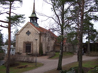
Siuntio is a municipality of Finland located in the Uusimaa region in the province of Southern Finland. Its neighboring municipalities are Ingå to the west, Kirkkonummi, to the east, Lohja to the north-west, and Vihti to the north. It is 46 kilometres (29 mi) west of Helsinki.

Klaukkala is the southern-most urban area of the Nurmijärvi municipality in Uusimaa, Finland, located near Lake Valkjärvi. It is the largest urban area in Nurmijärvi, and despite the fact that it officially has the status of a village, it's often mistakenly thought to be a separate town due to its size and structure. In the 2010s, Klaukkala's urban area grew to be part of the larger Helsinki urban area.

The Old Church of Helsinki, designed by Carl Ludvig Engel and completed in 1826, is an Evangelical Lutheran church in Helsinki. The oldest existing church in central Helsinki, the church was originally planned as a temporary building as the Ulrika Eleonora Church constructed in 1727 had become too small for the congregation and the new church, Helsinki Cathedral, would not be completed until 1852. However, the city's rapid population growth from the early 19th century onwards ensured that the church would remain needed, and also necessitated the construction of many other churches.

Tyrvää was a municipality in the Satakunta region, Turku and Pori Province, Finland. It was established in 1439 when the Tyrvää parish was separated from the parish of Karkku. In 1915, the market town of Vammala was separated from Tyrvää, and in 1973, Tyrvää was consolidated with Vammala. In 2009, Vammala became a part of the newly established town Sastamala.
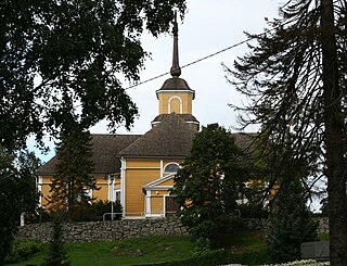
Nurmijärvi church is a wooden church in Nurmijärvi, built in 1793. The church was built by Matti Åkerblom. The bell tower was completed in 1795 and was built by Mats Åkergren. The church is the fourth wooden church built in the Nurmijärvi village, the previous church built in 1692 was demolished in 1793.

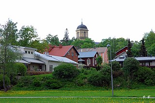
The Loppi church village is the largest village in the Loppi municipality on the northern shore of Lake Loppi (Loppijärvi) in Tavastia Proper, Finland, and also its administrative center with a population of more than 2,000. The distance from the village to the eastern town of Riihimäki is 19 kilometres (12 mi).

The Pihlajavesi railway station is located in the town of Keuruu, Finland, in the village of Pihlajavesi. It is located along the Haapamäki–Seinäjoki railway, and its neighboring stations are Haapamäki in the south and Myllymäki in the north.

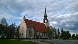
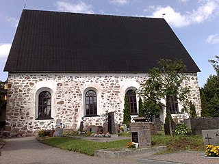
Pihlajavesi Old Church, also known as Pihlajavesi Wilderness Church, is a Lutheran church in the town of Pihlajavesi, in Central Finland. It is called 'Wilderness Church', because it is situated in a forest outside the main populated areas.
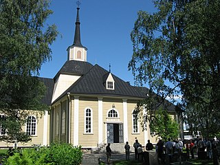
Gustav Adolf Church, also known as Iisalmi Old Church, is a wooden church in Iisalmi, Finland, which was consecrated in 1780. The Finnish Heritage Agency has classified the church as a nationally significant built cultural environment. Prior to the union of municipalities and parishes in the early 1970s, the Gustav Adolf Church was the main church of the Iisalmi rural parish, while the town parish used a new church completed in 1934. The church was to be named after the then Swedish heir to the crown, Gustav Adolf, and the use of the name was approved by the ruler later in the autumn.
Konginkangas is a settlement and former municipality of Finland in the Central Finland region. It was consolidated with Äänekoski in 1993.

Pohjaslahti is a village and former municipality of Finland at the time of its existence in the Häme Province, now in the Pirkanmaa region. It was divided between Vilppula and Virrat in 1973. Pohjaslahti was the last rural municipality to be created in Finland, which happened in 1941.

Koijärvi is a former municipality of Finland in the former Häme Province, now in Tavastia Proper. It was split between Forssa and Urjala in 1969, most of the land was given to Forssa.
Kulosaari Church is a Lutheran church located in the Kulosaari suburb of Helsinki, Finland.