Pilbara Coast

Last updated

Gales Bay at the southern end of Exmouth Gulf. Gales Bay.jpg
Gales Bay at the southern end of Exmouth Gulf.

The Pilbara Coast is the coastline of Western Australia's Pilbara region. It is often referred to as the North West Coast of Western Australia.

Contents

It is a complex array of river mouths, [1] ports, [2] peninsulas, and islands. [3]

Geography

North West Cape forms the western end of the Pilbara Coast. According to the ICMRA, the Pilbara Coast ends at Cape Keraudren, a rocky headland that forms the western end of Eighty Mile Beach. Others end it further east at Wallal. [4]

Lagoons protected by barrier islands, embayments, river deltas, and rocky headlands are the main coastal features. The Pilbara's intermittent rivers, including the Ashburton, Fortescue, Yule, and De Grey, have deposited sediment to form river deltas. There are many coastal islands, including the near-shore Dampier Archipelago, a cluster of rocky islands and reefs. The larger offshore islands include Barrow Island and the Montebello Islands. [5]

Cenozoic aeolian and beach rock deposits are common along the entire coastline. The western portion of the coast, from North West Cape to Cape Preston including Exmouth Gulf, is underlain by the sedimentary Carnarvon Basin formation. The eastern portion from Cape Preston to Cape Keraudren is near the northern margin of the Pilbara Craton, which is made up of Archaean metamorphic and igneous rocks. The Archean rocks outcrop in several places along the coast, including in the Dampier Archipelago and the adjacent mainland. The offshore islands are mostly composed of limestone, with sandy cays and fringing coral reefs. [5]

Climate

The climate is tropical and semi-arid. [5]

The North West Coast, including the Pilbara Coast and Eighty Mile Beach is the most cyclone-prone region of the entire Australian coastline. On average two cyclones cross the coast each year, one of which is severe. [6]

In Bureau of Meteorology reports, Pilbara Coast West runs from North West Cape to Cape Preston, and Pilbara Coast East is from Cape Preston to Wallal. [7]

Oceanography

The sea floor slopes gently away from the coast, and the 10-metre bathymetric contour is generally between 1 and 2 miles offshore. The waters are turbid near the shore, especially during the spring tides. Tidal range is large with a maximum of 2 to 6 metres. Wave energy is generally low, but cyclonic storms can bring large waves and storm surges. [5]

Ecology

Black-fronted dotterel (Elseyornis melanops) on the Pilbara Coast. Elseyornis melanops -Pilbara, Western Australia, Australia-8.jpg
Black-fronted dotterel (Elseyornis melanops) on the Pilbara Coast.

Australia's IMCRA system designates two bioregions on the Pilbara Coast. The Pilbara (nearshore) bioregion extends from the shore to the ten-metre bathymetric contour, and includes the Dampier Archipelago and other near-shore islands. The coastal lagoons and embayments are home to extensive mangrove systems, some of them more than 50 km long. Arid-climate mangroves are globally rare, and the Pilbara Coast has some of the largest areas of arid-climate mangrove on the planet. [5] The Pilbara Coast is home to five species of mangrove – Aegialitis annulata, Aegiceras corniculatum, Avicennia marina, Bruguiera exaristata, Ceriops tagal , and Rhizophora stylosa . Many birds, fishes, and invertebrates live in the mangroves. [8] The intertidal mud flats are home to abundant burrowing invertebrates, which sustain migratory and resident birds. [5]

The Pilbara (offshore) bioregion encompasses the clearer waters beyond the 10-metre depth contour and several offshore islands, including Barrow Island, the Montebello Islands, South and North Muiron, Serrurier, Bessieres, Thevenard, and the Rosily islands. The lower turbidity allows for abundant corals, which form fringing reefs and sustain a diverse coral reef flora and fauna, including many endemic species. [5]

Aboriginal peoples

The Australian Aboriginal peoples of the Pilbara Coast include, from west to east, the Thalanyji, Nhuwala, Martuthunira, Yapurarra, Ngarluma, Kariyarra, Nyamal, and Ngarla. [9]

Settlements

Roebourne Courthouse Roebourne Courthouse, G Temple Poole (1886).jpg
Roebourne Courthouse

Settlements on the coast include the towns of Exmouth, Onslow, Dampier, Karratha, Roebourne, and Port Hedland. Dampier is an industrial port which exports iron ore from the interior and liquified natural gas from the offshore Greater Gorgon gas field. Port Hedland's industrial port also exports iron ore.

Protected areas

See also

Related Research Articles

Great Australian Bight Open bay off southern Australia

The Great Australian Bight is a large oceanic bight, or open bay, off the central and western portions of the southern coastline of mainland Australia.

Dampier, Western Australia Town in Western Australia

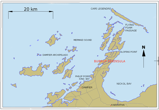
Dampier is a major industrial port in the Pilbara region in the northwest of Western Australia. It is located near the city of Karratha and Port Walcott.

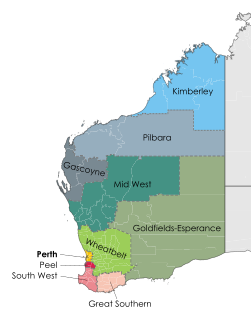
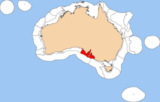
The Pilbara is a large, dry, thinly populated region in the north of Western Australia. It is known for its Aboriginal peoples; its ancient landscapes; the red earth; and its vast mineral deposits, in particular iron ore. It is also a global biodiversity hotspot for subterranean fauna.

North West Coastal Highway Highway in Western Australia

North West Coastal Highway is a generally north-south Western Australian highway which links the coastal city of Geraldton with the town of Port Hedland. The 1,300-kilometre-long (808 mi) road, constructed as a sealed two-lane single carriageway, travels through remote and largely arid landscapes. Carnarvon is the only large settlement on the highway, and is an oasis within the harsh surrounding environment. The entire highway is allocated National Route 1, part of Australia's Highway 1, and parts of the highway are included in tourist routes Batavia Coast Tourist Way and Cossack Tourist Way. Economically, North West Coastal Highway is an important link to the Mid West, Gascoyne and Pilbara regions, supporting the agricultural, pastoral, fishing, and tourism industries, as well as mining and offshore oil and gas production.

Karratha is a city in the Pilbara region of Western Australia, adjoining the port of Dampier. It was established in 1968 to accommodate the processing and exportation workforce of the Hamersley Iron mining company and, in the 1980s, the petroleum and liquefied natural gas operations of the North West Shelf Venture. As of June 2018, Karratha had an urban population of 16,708. The city's name comes from the cattle station of the same name, which derives from a word in a local Aboriginal language meaning "good country" or "soft earth". The city is the seat of government of the City of Karratha, a local government area covering the surrounding region.

Pilbara newspapers Newspapers published in the Pilbara region of Western Australia

Pilbara newspapers is a selection of newspapers published in the Pilbara region of Western Australia.

Depuch Island is a volcanic island located off the north-west coast of Western Australia's Pilbara region, near Port Hedland.

Northwest Shelf Province

The Northwest Shelf Province, also known as Exmouth to Broome, is a biogeographic region of Australia's continental shelf.

Spencer Gulf Shelf Province Marine bioregion in Southern Australia

The Spencer Gulf Shelf Province, also known as the South Australian Gulfs marine ecoregion, is a biogeographic region of Australia's continental shelf and coastal waters. It includes the warm temperate coastal waters of South Australia's central coast. It is a provincial bioregion in the Integrated Marine and Coastal Regionalisation of Australia (IMCRA) system.

Western Australia has the longest coastline of any state or territory in Australia, at 10,194 km or 12,889 km. It is a significant portion of the coastline of Australia, which is 35,877 km.

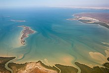
Cape Preston is a rocky headland located in the Pilbara region of Western Australia, situated 67 km (42 mi) West South West of Karratha. It lies on the tribal land of the indigenous Nhuwala.

Cyclone Clare Category 3 Australian region cyclone in 2006

Severe Tropical Cyclone Clare was a moderately strong cyclone that struck Western Australia in January 2006. The storm formed as an area of low pressure in the Arafura Sea, and moved westward. After receiving the name Clare on 7 January, the system ultimately peaked at Category 3 intensity on the Australian tropical cyclone scale. It moved ashore on the coast of Pilbara and proceeded inland, dissipating on 10 January. Clare produced winds of 142 km/h (88 mph) at Karratha and triggered widespread torrential rainfall that led to flooding. Following its usage, the name Clare was retired by the Bureau of Meteorology, and will never be used again for a tropical cyclone in the area.

Bedout Island Island in Western Australia

Bedout Island is a small Australian island in the eastern Indian Ocean. It lies 42 km offshore from Larrey Point and the mouth of the De Grey River, and 96 km north-east of Port Hedland, on the Pilbara coast of north-west Western Australia.

Port of Port Hedland Port in Australia

Port Hedland is one of the largest iron ore loading ports in the world and the largest in Australia. In 2011 it had the largest bulk cargo throughput in Australia. With the neighboring ports of Port Walcott and Dampier, Port Hedland is one of three major iron ore exporting ports in the Pilbara region of Western Australia,

Port Walcott, formerly known as Tien Tsin Harbour, is a large open water harbour located on the northwest coast of Western Australia, located near the town of Point Samson.

Pilbara shrublands Terrestrial ecoregion in Western Australia

The Pilbara shrublands is a deserts and xeric shrublands ecoregion in Western Australia. It is coterminous with the Pilbara IBRA region. For other definitions and uses of "Pilbara region" see Pilbara.

The Dampier Marine Park is an Australian marine park offshore of Western Australia, north-east of Karratha. The marine park covers an area of 1,252 km2 (483 sq mi) and is assigned IUCN category VI. It is one of the 13 parks managed under the North-west Marine Parks Network.

Marine ecoregions of the South African exclusive economic zone Geographical regions of similar ecological characteristics

The marine ecoregions of the South African exclusive economic zone are a set of geographically delineated regions of similar ecological characteristics on a fairly broad scale, covering the exclusive economic zone along the South African coast.

Cyclone Damien Category 2 Cyclone in 2020

Severe Tropical Cyclone Damien was the strongest cyclone to make landfall in the Western Australian coast since Cyclone Christine in 2013. It was also the strongest Cyclone in the 2019–20 Australian region cyclone season. The fifth tropical low, and the third named storm of the 2019–20 Australian region cyclone season, Damien originated from a monsoon trough over Kimberley.

Cape Keraudren is a coastal headland on the northern coast of Western Australia.

References

  1. "Tour | Australia's North West".
  2. "Home". pilbaraports.com.au.
  3. Taylor, David; Branson, Paul; Treloar, Doug (2011), "Monte Carlo cyclone track model system for the Pilbara coast", Coasts and Ports 2011 : Diverse and Developing: Proceedings of the 20th Australasian Coastal and Ocean Engineering Conference and the 13th Australasian Port and Harbour Conference, Engineers Australia: 712–718, ISBN   978-0-85825-886-0
  4. Pilbara Tourism Association (2002), Discovering the central Pilbara coast , retrieved 14 December 2015
  5. 1 2 3 4 5 6 7 Thackway R, Cresswell ID. 1998. Interim Marine and Coastal Regionalisation for Australia: An Ecosystem-based Classification for Marine and Coastal Environments. Version 3.3. Canberra (Australia): Environment Australia, Commonwealth Department of the Environment.
  6. http://www.bom.gov.au/cyclone/climatology/wa.shtml "Climatology of Tropical Cyclones in Western Australia" Bureau of Meteorology, Government of Australia. Accessed 19 July 2021.
  7. http://www.bom.gov.au/wa/forecasts/map.shtml Western Australian Forecast Map
  8. Jones, Diana S. (2004). "The Burrup Peninsula and Dampier Archipelago, Western Australia: an introduction to the history of its discovery and study, marine habitats and their flora and fauna". Records of the Western Australian Museum Supplement No. 66: 27–49 (2004).
  9. "Map of Indigenous Australia". AIATSIS. Accessed 20 July 2021. https://aiatsis.gov.au/explore/map-indigenous-australia