Pilgerbach is a 8-kilometre-long (5.0mi) river of north Hesse, Germany, in the district of Edermünde. It is a westerly tributary of the Eder into which it flows near Edermünde-Grifte, just before the Eder flows into the Fulda. The name Pilgerbach can be translated in English as Pilgrim's stream.
Course
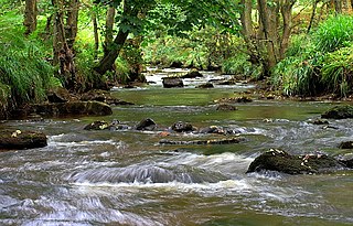
The Pilgerbach rises in the nature park of the Habichtswald near Kassel. The spring is on the eastern flank of the 464.8-metre-high (1,525ft) Benberg hill and the northern flank of the 460-metre-high (1,510ft) Bilstein hill, ca. 1.5km (0.93mi) northwest of Besse.
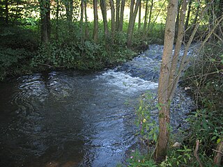
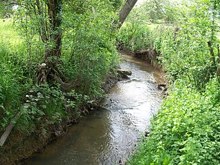
After leaving the forest, the river flows through arable land to the south-west of Besse, before it passes the westerly and southern parts of the same town and leaves the nature park. At this point the Saugraben tributary meets the Pilgerbach from the west. As it flows further eastwards it passes mainly arable and pasture land. Next to the L3221 road it reaches the basaltknollHahn before passing through Edermünde-Holzhausen. On the western edge of this village it meets the Glisborn tributary, which comes from the southwest. After passing under the Autobahn A49 it meets the tributary of the Hertingshausener Bach, and flows next to the L3221 road to the town of Grifte. In this village it flows partly through tunnels and canals. After passing under the railway track, just to the east of Grifte, it flows in to the Eder river, which in turn flows in the Fulda in just 550m (1,800ft) further on.
The Aare or Aar is a tributary of the High Rhine and the longest river that both rises and ends entirely within Switzerland.
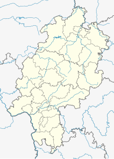
Schwalm-Eder-Kreis is a Kreis (district) in the north of Hesse, Germany. Neighbouring districts are Kassel, Werra-Meißner, Hersfeld-Rotenburg, Vogelsberg, Marburg-Biedenkopf, and Waldeck-Frankenberg.
The Fulda is a river of Hesse and Lower Saxony, Germany. It is one of two headstreams of the Weser. The Fulda is 220.4 kilometres (137.0 mi) long.
The Lahn is a 245.6-kilometre-long (152.6 mi), right tributary of the Rhine in Germany. Its course passes through the federal states of North Rhine-Westphalia (23.0 km), Hesse (165.6 km), and Rhineland-Palatinate (57.0 km).
The Eder[ˈeːdɐ] is a 177-kilometre (110 mi)-long major river in Germany that begins in eastern North Rhine-Westphalia and passes in to Hesse, where it empties into the River Fulda.
The River Anker is a river in England that flows through the centre of Nuneaton. It is a major tributary of the River Tame, which it joins in Tamworth. The name of the river derives from an old British term for winding river. From source to river mouth at Tamworth is 50 kilometres (31 mi).
Edermünde is a community in northern Hesse, Germany.
The South Negril River is a river in Westmoreland, Jamaica.
The West Hesse Depression is part of the West Hesse Highlands and Lowlands region in the north of the German state of Hesse. Like the East Hesse Depression, it is a series of separate depressions that form a natural corridor and have been an important historical trade route.
The East Hesse Highlands describes a heavily wooded range of hills lying mainly in the German state of Hesse, but also extending a little way into Lower Saxony to the north, Thuringia to the east and Bavaria to the southeast. The region is sandwiched between the West Hesse Depression to the west, the Weser Uplands to the north, the Thuringian Basin to the northeast, the northwestern edge of the Thuringian Forest to the east, the Spessart to the south and the Wetterau to the southwest.
The Rothaarsteig is a 154.80 km long hiking trail along the crest of the Rothaargebirge mountain range in Germany in the border region between the states of North Rhine-Westphalia (NW) and Hesse (HE). It was opened in 2001.
The Breitenbach in Baden-Württemberg, Landkreis Reutlingen, is a southern and orographic left tributary of the Echaz. It is about 8.9 kilometres (5.5 mi) long. It is a southern and left tributary of the Echaz, which is located in Reutlingen..
The Rhünda, also called the Rhündabach, is a 12.9 kilometres (8.0 mi) long, eastern tributary of the River Schwalm in the Schwalm-Eder-Kreis, North Hesse, Germany.
The Weiß is a river of North Rhine-Westphalia, Germany, which is 18.1 kilometers (11.2 mi) in length. Its source is near the mountain Kalteiche, at a height of 493 meters (1,617 ft) above sea level. Then it flows through the villages Wilgersdorf, Rudersdorf, Anzhausen, Niederdielfen, Kaan-Marienborn, and the city Siegen. The Weiß flows into the Sieg in Siegen, at 247 meters elevation.
The Glisborn, or Glißborn, is a small, short stream that rises from a spring of the same name. The spring is located close to the Odenberg hill near Gudensberg in the northern Hessian district of Schwalm-Eder-Kreis. The spring is connected with numerous legends.
The Langenberg, also colloquially called the Langenberge (plural) due to its several and widely spaced hilltops, is a hill range of the German Central Uplands which covers an area of over 22 km² and reaches a height of 556.7 m above sea level (NHN) at the Schwengeberg. It is a natural region in the Habichtswald Highlands in the counties of Kassel and Schwalm-Eder-Kreis in North Hesse.
The Badsey Brook, also known as the Broadway Brook, is a small brook that flows through Worcestershire, England. It is a lower tributary of the River Avon, which it joins near Offenham upstream of Evesham. Its principal tributary is the Bretforton Brook.
Hodge Beck is a stream that flows through the North York Moors national park in North Yorkshire, England. It is a tributary of the River Dove which it joins near Welburn south of Kirkbymoorside. The beck is 14 miles (23 km) long and has a total catchment area of 58 square kilometres (22 sq mi).
Crimple Beck or the River Crimple is a beck which flows through North Yorkshire, England. It is a tributary of the River Nidd which it joins between Little Ribston and Walshford north of Wetherby. The beck is 15.5 miles (24.9 km) long, and has a total catchment area of 80 square kilometres (31 sq mi), which drains the area around Harrogate. Its tributaries include the Park Beck.
The Söhre is a forested hill range of the German Central Uplands and a subordinate natural region of the Fulda-Werra Uplands in North Hesse, Germany.
This page is based on this Wikipedia article Text is available under the CC BY-SA 4.0 license; additional terms may apply. Images, videos and audio are available under their respective licenses.