Hahn (Holzhausen)

Last updated
Hahn
Hahn (Holzhausen)
Highest point
Elevation 255.8 m (839 ft)  Normalhöhennull
Prominence 47 m (154 ft)Bilstein
Isolation 4.25 km (2.64 mi)
Coordinates 51°13′01″N9°25′14″E / 51.216909437°N 9.4204226302°E / 51.216909437; 9.4204226302 Coordinates: 51°13′01″N9°25′14″E / 51.216909437°N 9.4204226302°E / 51.216909437; 9.4204226302
Geography
Location Schwalm-Eder-Kreis, Hesse, Germany
Parent range West Hesse Depression
Geology
Age of rock Miocene
Mountain type neck of an extinct volcano
Type of rock basalt

The Hahn is a 255.8 m (839 ft)-high basalt knoll in the district of Schwalm-Eder-Kreis, within the town of Edermünde-Holzhausen, in Hesse, Germany. Like many other basalt outcrops in the West Hesse Depression, it is the neck of an extinct Miocene volcano, the rest has been eroded. [1] A small medieval tower castle once stood on the hill.

Basalt A magnesium- and iron-rich extrusive igneous rock

Basalt is a mafic extrusive igneous rock formed from the rapid cooling of magnesium-rich and iron-rich lava exposed at or very near the surface of a terrestrial planet or a moon. More than 90% of all volcanic rock on Earth is basalt. Basalt lava has a low viscosity, due to its low silica content, resulting in rapid lava flows that can spread over great areas before cooling and solidification. Flood basalt describes the formation in a series of lava basalt flows.

A hillock or knoll is a small hill, usually separated from a larger group of hills such as a range. Hillocks are similar in their distribution and size to small mesas or buttes. The term is largely a British one. This particular formation occurs often in Great Britain and China. A similar type of landform in the Scandinavian countries goes by the name ”kulle” or ”bakke” and is contrary to the above phenomena formed when glaciers polish down hard, crystalline bedrock of gneiss or granites, leaving a rounded rocky hillock with sparse vegetation.

Schwalm-Eder-Kreis District in Hesse, Germany

Schwalm-Eder-Kreis is a Kreis (district) in the north of Hesse, Germany. Neighbouring districts are Kassel, Werra-Meißner, Hersfeld-Rotenburg, Vogelsberg, Marburg-Biedenkopf, and Waldeck-Frankenberg.

Contents

Location

The knoll is located directly north of the town centre of Holzhausen. For this reason the town is often known as Holzhausen am Hahn (engl. Holzhausen on the Hahn). The Pilgerbach stream flows around the southern edge of the Hahn. On the eastern side there is a football field. To the west, the Autobahn A49 passes by.

Pilgerbach is a 8-kilometre (5.0 mi)-long river of north Hesse, Germany, in the district of Edermünde. It is a westerly tributary of the Eder into which it flows near Edermünde-Grifte, just before the Eder flows into the Fulda. The name Pilgerbach can be translated in English as Pilgrim's stream.

Autobahn national expressway in Germany

The Autobahn is the federal controlled-access highway system in Germany. The official German term is Bundesautobahn, which translates as "federal motorway". The literal meaning of the word Bundesautobahn is "Federal Auto(mobile) Track".

History of the Tower

Count Werner IV von Grüningen (1060-1121), [2] [3] who founded the Benedictine Monastery of Breitenau near Guxhagen in 1113, [4] built a tower castle around 1100 on the Hahn. The castle is first mentioned in documents in 1111. [5] It probably consisted of a tower castle on top of the hill, with further fortification on the lower plateau. [6] The buildings were probably destroyed before 1294 and fell down after 1346. [5] The ruins of the castle were still mentioned in the 16th Century, and at the beginning of the 19th Century, when material was removed for paths and roads, masonry stones and mortar, as well as human remains were found. All traces of the castle have now been removed.

Guxhagen Place in Hesse, Germany

Guxhagen is a community in Schwalm-Eder district in northern Hesse, Germany.

Tower castle

A tower castle is a small castle that mainly consists of a fortified tower or a tower-like structure that is built on natural ground. It is thus different from the motte-and-bailey castle, which it may resemble, but whose main defensive structure is built on a motte or artificial hill. The tower castle is occasionally also described as a tower house castle or a tower house.

Culture

In the 1980s, a rock- and pop-festival was organised in Holzhausen called 'Rock-am-Hahn'. It featured rock bands such as the 'Rodgau Monotones', Opus, Wolfgang Ambros and Klaus Lage. [7] This festival was revived in 2006 by the local youth organisations. Its primary objective is to promote up-and-coming bands.

Opus (Austrian band) Austrian pop-rock band

Opus is a pop-rock group from Graz, Austria. Formed in 1973, the group remains active today. The band is chiefly known for its 1985 single release, "Live Is Life", which reached the Top 10 in several European countries.

Wolfgang Ambros Austrian singer

Wolfgang Ambros is an Austrian singer-songwriter, most famously known for setting the then-new trend in the 1970s known now as Austropop. He is most famous for his song "Da Hofa" and "Schifoan".

Klaus Lage German musician

Klaus Lage is a musician from Soltau, Germany. He is known for his 1984 single "1000 und 1 Nacht (Zoom!)".

Other Facts

On the hill there are ca. two hectares of forest, the basalt cliffs and the south-eastern flank are not forested. The plateau is designated a protected nature area. In 1999 and 2000 the citizens of Holzhausen remediated the path to the top of the hill. From here a good view of Holzhausen and the surrounding area can be seen.

Hectare metric unit of area

The hectare is an SI accepted metric system unit of area equal to a square with 100-metre sides, or 10,000 m2, and is primarily used in the measurement of land. There are 100 hectares in one square kilometre. An acre is about 0.405 hectare and one hectare contains about 2.47 acres.

Related Research Articles

Hesse State in Germany

Hesse or Hessia, officially the State of Hesse, is a federal state (Land) of the Federal Republic of Germany, with just over six million inhabitants. The state capital is Wiesbaden; the largest city is Frankfurt am Main.

Rhön Mountains low mountain range in Germany

The Rhön Mountains are a group of low mountains in central Germany, located around the border area where the states of Hesse, Bavaria and Thuringia come together. These mountains, which are at the extreme southeast end of the East Hesse Highlands, are partly a result of ancient volcanic activity. They are separated from the Vogelsberg Mountains by the river Fulda and its valley. The highest mountain in the Rhön is the Wasserkuppe which is in Hesse. The Rhön Mountains are a popular tourist destination and walking area.

Felsberg, Hesse Place in Hesse, Germany

Felsberg is a town in the Schwalm-Eder district about 25 kilometres south of Kassel.

Amöneburg Place in Hesse, Germany

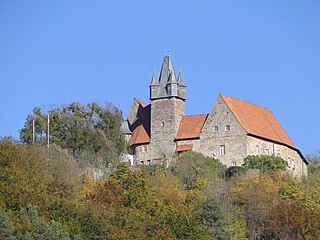
Amöneburg is a town in the Marburg-Biedenkopf district in Hesse, Germany. It lies on a mountain and is built around the castle of the same name, Burg Amöneburg.

Ebsdorfergrund Place in Hesse, Germany

Ebsdorfergrund is a community consisting of eleven villages in the southeast of Marburg-Biedenkopf district in Hesse, Germany.

Edermünde Place in Hesse, Germany

Edermünde is a community in northern Hesse, Germany.

Gudensberg Place in Hesse, Germany

Gudensberg is a small town in northern Hesse, Germany. Since the municipal reform in 1974, the nearby villages of Deute, Dissen, Dorla, Gleichen, Maden and Obervorschütz have become parts of the municipality.

West Hesse Highlands mountains in Germany

The West Hesse Highlands, also known as the West Hessian Lowlands and Highlands, refers to a heavily forested region of the Central Uplands in Germany that lies mostly within the state of Hesse, between those elements of the Rhenish Massif right of the Rhine in the west, the Weser Uplands to the north, the Hessian Central Uplands to the east and the Wetterau to the south.

West Hesse Depression

The West Hesse Depression is part of the West Hesse Highlands and Lowlands region in the north of the German state of Hesse. Like the East Hesse Depression, it is a series of separate depressions that form a natural corridor and have been an important historical trade route.

Beilstein (Spessart) mountain in Germany

The Beilstein is a hill in the Main-Kinzig district of Hesse, Germany. It is part of the Spessart range and lies in the municipality of Jossgrund close to the Ortsteil of Lettgenbrunn. Its elevation is 499 metres above sea level.

Heiligenburg Castle

Heiligenburg Castle is a castle on the hill of Heiligenberg in the district of Schwalm-Eder-Kreis, Hesse, Germany.

Spangenberg Castle (Hesse) former castle and 2nd World War POW camp, in the state of Hesse

Spangenberg Castle is a schloss above the small German town of Spangenberg in the North Hesse county of Schwalm-Eder-Kreis. The originally Gothic building was first a medieval fortified castle, then a fortress, hunting lodge, prison, forestry school and is now a hotel and restaurant.

Otzberg Castle castle

Otzberg Castle in the German state of Hesse is a medieval castle on the summit of the Otzberg in the Odenwald forest at a height of 367 m above NN. On its northern slopes is the village of Hering, which grew out of the lower ward or castellan's settlement. The history of castle and village is therefore closely interwoven.

Greifenstein Castle (Hesse) castle in Greifenstein, Hesse, Germany

Greifenstein Castle lies in the eponymous village of Greifenstein in the county of Lahn-Dill-Kreis in Middle Hesse, Germany. It is a geo point in the national geopark of Westerwald-Lahn-Taunus.

Middle Hesse one of three planning regions in the German state of Hesse

The region of Middle Hesse is one of three planning regions in the German state of Hesse, alongside North and South Hesse. Its territory is identical with that of the administrative province of Gießen and covers the counties of Limburg-Weilburg, Lahn-Dill-Kreis, Gießen, Marburg-Biedenkopf and Vogelsbergkreis. The Middle Hesse Regional Assembly, which decides on the regional plan, currently consists of 31 members chosen by the five counties and the three towns with special status: Gießen, Marburg and Wetzlar. The regional assembly has tasked the governing president (Regierungspräsident) with delivering regional management. The Mid-Hesse Regional Management Association was founded on 22 January 2003.

Sababurg castle ruin

The Sababurg, first called the Zappenburg, then Zapfenburg and today, after the Brothers Grimm fairy tale Sleeping Beauty Castle, is the ruin of a hill castle in the legendary Reinhardswald, a forested upland that runs through the North Hessian county of Kassel. Sababurg is also the name of a district of the town of Hofgeismar in which the castle is found.

Upper Hessian Ridge

The Upper Hessian Ridge or Upper Hesse Ridge is a hill chain in the West Hesse Highlands in North and Middle Hesse, which lies on the Rhine-Weser watershed and links the montane Central Upland ranges of the Kellerwald and the Vogelsberg in a north-south direction. The swell is divided into the Gilserberg Heights in the north, the central Neustadt Saddle and the Northern Vogelsberg Foreland in the south.

Vogelsberg low mountain range in Germany

The Vogelsberg  is a large volcanic mountain range in the German Central Uplands in the state of Hesse, separated from the Rhön Mountains by the Fulda river valley. Emerging approximately 19 million years ago, the Vogelsberg is Central Europe's largest basalt formation, consisting of a multitude of layers that descend from their peak in ring-shaped terraces to the base.

Schloss Holzheim (hunting seat) former hunting seat of the ruling family of Hesse-Kassel

Schloss Holzheim is a former hunting seat of the ruling family of Hesse-Kassel, located in the village of Holzheim in the German state of Hesse, approximately 80 kilometres (50 mi) south of Kassel. The hunting lodge was built between 1732 and 1735 under Frederick I, King of Sweden and also Landgrave of Hesse-Kassel, in baroque style on the medieval foundation walls of the former manor house of the local noble families Von Holzheim and Von Romrod. Frederick's father, Landgrave Charles I, Landgrave of Hesse-Kassel had often come here for hunting. Frederick's brother and governor, Prince William, liked to be here as well because of the rich game population of the forest areas around the princely estate.

Lichtenstein Castle (Greifenstein) castle

Lichtenstein Castle is a levelled spur castle on the hill of Burgberg Lichtenstein, 315 m above sea level (NN), near the Greifenstein village of Holzhausen on the old military High Road, that ran from Frankfurt via Wetzlar to Cologne. The castle site is situated to the north of, and above, the Ulmbach Reservoir in the Hessian county of Lahn-Dill-Kreis.

References

  1. Wedepohl, Karl Hans (1985). "Origin of the Tertiary basaltic volcanism in the Northern Hessian Depression". Contributions to Mineralogy and Petrology. 89: 122–143. doi:10.1007/BF00379448. ISSN   0010-7999.
  2. Thomas Grueningen. "The counts Werner of Grueningen in Hesse" (in German). Retrieved 11 Feb 2015.
  3. Bayerischen Staatsbibliothek. "Werner, Graf von Grüningen" (in German). Allgemeine Deutsche Biographie [Onlinefassung]. Retrieved 11 Feb 2015.
  4. "Klöster Breitenau" [Breitenau Monastery] (in German). RegioWiki der HNA. Retrieved 11 Feb 2015.
  5. 1 2 "Burg am Hahn" (in German). Hessian Regional History Information System. Retrieved 11 Feb 2015.
  6. Knappe, Rudolf (1995). Mittelalterliche Burgen in Hessen: 800 Burgen, Burgruinen und Burgstätten[Medieval castles in Hessen: 800 castles, ruined castles and fortified settlements] (in German). Wartberg-Verlag. p. 92. ISBN   3-86134-228-6.
  7. "Rock-am-Hahn" (in German). Edermünder Jugendausschuss. Retrieved 11 Feb 2015.