
Surry County is a county located in the U.S. state of North Carolina. As of the 2020 census, the population was 71,359. Its county seat is Dobson, and its largest community is Mount Airy.
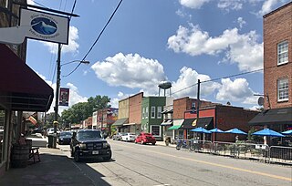
Pilot Mountain is a town in Surry County, North Carolina, United States. The population was 1,443 at the 2020 census. It is named for the nearby landmark of Pilot Mountain, a distinctive geological formation.

A pyramidal peak, sometimes called a glacial horn in extreme cases, is an angular, sharply pointed mountain peak which results from the cirque erosion due to multiple glaciers diverging from a central point. Pyramidal peaks are often examples of nunataks.

The George Washington and Jefferson National Forests is an administrative entity combining two U.S. National Forests into one of the largest areas of public land in the Eastern United States. The forests cover 1.8 million acres (2,800 sq mi) of land in the Appalachian Mountains of Virginia, West Virginia, and Kentucky. Approximately 1 million acres (1,600 sq mi) of the forest are remote and undeveloped and 139,461 acres (218 sq mi) have been designated as wilderness areas, which prohibits future development.
The Aviator Glacier is a major valley glacier in Antarctica that is over 60 nautical miles long and 5 nautical miles wide, descending generally southward from the plateau of Victoria Land along the west side of Mountaineer Range, and entering Lady Newnes Bay between Cape Sibbald and Hayes Head where it forms a floating tongue.
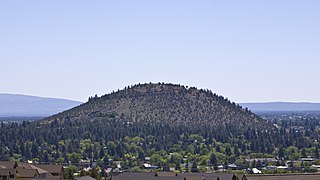
Pilot Butte is a lava dome that was created from an extinct volcano located in Bend, Oregon. It is a cinder cone butte which rises nearly 500 feet (150 m) above the surrounding plains. Bend is one of six cities in the United States to have a volcano within its boundaries. The other examples are Mount Tabor in Portland, Oregon, Jackson Volcano in Jackson, Mississippi, Diamond Head in Honolulu, Glassford Hill in Prescott Valley and Pilot Knob in Austin, Texas.
The Connecticut Open was a professional tennis tournament played on outdoor hard courts under various names and in various venues from 1948 until 2019.

Pilot Peak is the highest mountain in the Pilot Range in extreme eastern Elko County, Nevada, United States. It is the most topographically prominent peak in Elko County and the fourth-most prominent peak in Nevada. The peak is on public land administered by the Bureau of Land Management and thus has no access restrictions.

Huron Peak is a high mountain summit of the Collegiate Peaks in the Sawatch Range of the Rocky Mountains of North America. The 14,012-foot (4,271 m) fourteener is located in the Collegiate Peaks Wilderness of San Isabel National Forest, 18.0 miles (28.9 km) west-northwest of the Town of Buena Vista in Chaffee County, Colorado, United States.
Mount Cabot is a mountain located in Coos County, in the U.S. state of New Hampshire. The mountain is the highest peak of the Pilot Range of the White Mountains. Cabot is flanked to the northeast by The Bulge, and to the south of Bunnell Notch by Terrace Mountain. Mount Cabot was named in honor of the Italian explorer Sebastian Cabot.
Mountain Air Cargo (MAC) is an American cargo airline based in Denver, North Carolina. It is a major contract carrier for FedEx Express, operating in the eastern United States and the Caribbean region. Previous turboprop operations in South America have been discontinued by FedEx, which now operates jet aircraft in that area. MAC is one of the largest feeder airlines in the United States. Its main maintenance facility is at Kinston Regional Jetport. All of the ATR, C208, and C408 aircraft operated by Mountain Air are owned by FedEx Express, and are operated by MAC on a "dry lease" basis.
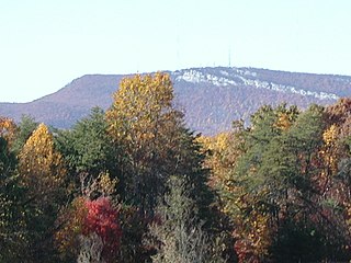
The Sauratown Mountains, which are sometimes called "the mountains away from the mountains", are an isolated mountain range located within Stokes and Surry counties in the U.S. state of North Carolina. The vast majority of the range is located in Stokes County. Although the range occupies only 5% of Stokes County's area, it dominates the county's scenery from almost every direction. The Sauras rise sharply 800 to 1,700 feet above the surrounding terrain.

Bomber Mountain is the crest of a ridge line within the Bighorn Mountains of the U.S. State of Wyoming. It borders the south side of Cloud Peak, the tallest peak in the range. It is about 23 miles (37 km) west of Buffalo. A military aviation accident that occurred upon the mountain in 1943 led to it being named Bomber Mountain in 1946. For more info see, "The Bomber Mountain Crash: A Wyoming Mystery" by Scott Madsen, Published and Copyrighted in September, 1990

Pilot Knob is located in the Arcadia Valley of Iron County, Missouri, between the towns of Ironton and Pilot Knob. Pilot Knob, so named because of its distinctive shape and prominent position, reaches an elevation of 1,470 feet (450 m) rising 581 feet (177 m) above the Arcadia Valley floor and has a large deposit of iron ore in its upper regions. Pilot Knob is a peak in the St. Francois Mountains.
Fendorf Glacier is a broad glacier draining from the eastern slopes of the Gifford Peaks and flowing north to merge with Dobbratz Glacier, in the Heritage Range of the Ellsworth Mountains, Antarctica. It was mapped by the United States Geological Survey from ground surveys and U.S. Navy air photos, 1961–66, and was named by the Advisory Committee on Antarctic Names for Lieutenant Commander James E. Fendorf, U.S. Navy, a pilot with Squadron VX-6 during Operation Deep Freeze 1966.
The Pilot Range is located in the White Mountains of New Hampshire in the United States. The Pilot Range extends southeast–northwest about 15 miles (24 km). The highest peak in the range is Mount Cabot, with an elevation of 4,160 feet (1,270 m).

Pilot Peak, elevation 11,699 feet (3,566 m), is a prominent mountain peak in the Absaroka Range in Park County, Wyoming. The peak is visible from US Route 212, the Beartooth Highway just east of the Northeast Entrance Station to Yellowstone National Park. Index Peak rises just north of Pilot Peak.

Pilot Knob is a 12,245-foot-elevation (3,732 meter) mountain summit located in Fresno County in the Sierra Nevada mountain range in northern California, United States. It is situated at the intersection of Piute Canyon and French Canyon, in the John Muir Wilderness, on land managed by Sierra National Forest. It is set 2.5 miles (4.0 km) south of Merriam Peak and three miles north of the Matthes Glaciers. Pilot Knob is the 360th-highest peak in California, and topographic relief is significant as the west aspect rises 2,800 feet above Hutchinson Meadow in approximately one mile. This mountain was likely named by the USGS during the 1907–09 survey for the Mt. Goddard Quadrangle, and the toponym has been officially adopted by the U.S. Board on Geographic Names.
