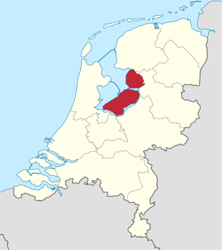
Flevoland is the twelfth and newest province of the Netherlands, established in 1986, when the southern and eastern Flevopolders, together with the Noordoostpolder, were merged into one provincial entity. It is in the centre of the country in the former Zuiderzee, which was turned into the freshwater IJsselmeer by the closure of the Afsluitdijk in 1932. Almost all of the land belonging to Flevoland was reclaimed in the 1950s and 1960s while splitting the Markermeer and Bordering lakes from the IJsselmeer. As to dry land, it is the smallest province of the Netherlands at 1,410 km2 (540 sq mi), but not gross land as that includes much of the waters of the fresh water lakes (meres) mentioned.

A polder is a low-lying tract of land that forms an artificial hydrological entity, enclosed by embankments known as dikes. The three types of polder are:
- Land reclaimed from a body of water, such as a lake or the seabed
- Flood plains separated from the sea or river by a dike
- Marshes separated from the surrounding water by a dike and subsequently drained; these are also known as koogs, especially in Germany
Lelystad is a Dutch municipality and the capital city of the province of Flevoland in the central Netherlands. The city, built on reclaimed land, was founded in 1967 and was named after Cornelis Lely, who engineered the Afsluitdijk that made the reclamation possible. Lelystad is situated approximately three metres below sea level.

The IJsselmeer, also known as Lake IJssel in English, is a closed-off inland bay in the central Netherlands bordering the provinces of Flevoland, North Holland and Friesland. It covers an area of 1,100 km2 (420 sq mi) with an average depth of 4.5 m (15 ft). The river IJssel, which the lake was named after, flows into the IJsselmeer.

The Zuiderzee or Zuider Zee was a shallow bay of the North Sea in the northwest of the Netherlands, extending about 100 km inland and at most 50 km wide, with an overall depth of about 4 to 5 metres (13–16 feet) and a coastline of about 300 km. It covered 5,000 km2 (1,900 sq mi). Its name is Dutch for "southern sea", indicating that the name originates in Friesland, to the north of the Zuiderzee.
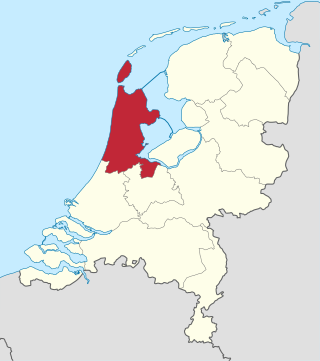
North Holland is a province of the Netherlands in the northwestern part of the country. It is located on the North Sea, north of South Holland and Utrecht, and west of Friesland and Flevoland. As of January 2023, it had a population of about 2,952,000 and a total area of 4,092 km2 (1,580 sq mi), of which 1,429 km2 (552 sq mi) is water.
The Zuiderzee Works is a system of dams and dikes, land reclamation and water drainage work, which was the largest hydraulic engineering project undertaken by the Netherlands during the twentieth century. The project involved the damming of the Zuiderzee, a large, shallow inlet of the North Sea, and the reclamation of land in the newly enclosed water using polders. Its main purposes are to improve flood protection and create additional land for agriculture.

Andijk is a former municipality and a village bordering Lake IJssel in the Netherlands, in the province of North Holland and the region of West-Frisia. Since 1 January 2011 Andijk has been part of Medemblik municipality.

Beemster is a former municipality in the Netherlands, in the province of North Holland. The Beemster is the first so-called polder in the Netherlands that was reclaimed from a lake, the water being extracted from the lake by windmills. The Beemster polder was drained between 1609 and 1612. It has preserved intact its well-ordered landscape of fields, roads, canals, dykes and settlements, laid out in accordance with classical and Renaissance planning principles. A grid of canals parallels the grid of roads in the Beemster. The grids are offset: the larger feeder canals are offset by approximately one kilometer from the larger roads.

Wieringermeer is a former municipality and a polder in the Netherlands, in the province of North Holland. Since 2012 Wieringermeer has been a part of the new municipality of Hollands Kroon.

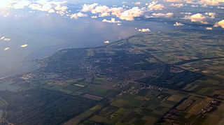
Emmeloord is the administrative centre of the municipality of Noordoostpolder, Flevoland, Netherlands. In 2019, it had a population of 26,055.

On 17 April 1945, the retreating German occupying forces inundated the polder of Wieringermeer, the Netherlands.
Wieringerwerf is a town in the Dutch province of North Holland. It is a part of the municipality of Hollands Kroon, and lies about 21 kilometres (13 mi) southeast of Den Helder. It is situated in a polder. The elevation of the village is 4 metres (13 ft) below sea level. Dikes and pumping engines keep the land dry.

The Markerwaard is the name of a proposed, but never built, polder adjoining the IJsselmeer in the central Netherlands. Its construction would have resulted in the near-total reclamation of the Markermeer.
The Holland Marsh is a wetland and agricultural area in Ontario, Canada, about 50 kilometres (31 mi) north of Toronto. It lies entirely within the valley of the Holland River, stretching from the northern edge of the Oak Ridges Moraine near Schomberg to the river mouth at Cook's Bay, Lake Simcoe. In its entirety it comprises about 21,000 acres, with two distinct divisions. Historically it has simply been referred to as "the marsh".

Flood control is an important issue for the Netherlands, as due to its low elevation, approximately two thirds of its area is vulnerable to flooding, while the country is densely populated. Natural sand dunes and constructed dikes, dams, and floodgates provide defense against storm surges from the sea. River dikes prevent flooding from water flowing into the country by the major rivers Rhine and Meuse, while a complicated system of drainage ditches, canals, and pumping stations keep the low-lying parts dry for habitation and agriculture. Water control boards are the independent local government bodies responsible for maintaining this system.

The Flevopolder is an island polder forming the bulk of Flevoland, a province of the Netherlands. Created by land reclamation, its northeastern part was drained in 1955 and the remainder—the southwest—in 1968.
The Markermeer is a 700 km2 (270 sq mi) lake in the central Netherlands in between North Holland, Flevoland, and its smaller and larger neighbors, the IJmeer and IJsselmeer. A shallow lake at 3 to 5 m in depth, matching the reclaimed land to its west, north-west and east it is named after the small former island, now peninsula, of Marken on its west shore.

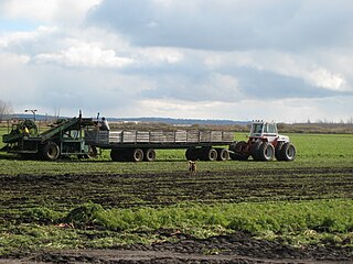
Land reclamation in the Netherlands has a long history. As early as in the 14th century, the first reclaimed land had been settled. Much of the modern land reclamation has been done as a part of the Zuiderzee Works since 1919.

Hermanus Johannes Lovink was a Dutch agriculturist, horticulturist, and politician. The son of a gardener, Lovink took to agriculture and horticulture from a young age, becoming the supervisor of public lands in Zutphen in 1887. Building on this experience, he gained a leadership position with the Association for Wasteland Redevelopment, in which capacity he oversaw several land reclamation projects. After being appointed Director General of Agriculture by Johannes Christiaan de Marez Oyens in 1901, he expanded agricultural education and promoted agricultural expansion; he continued these programs in the Dutch East Indies after being made Director of the Department of Agriculture, Industry, and Trade by Alexander Idenburg in 1909.

