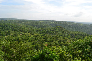
Sonbhadra or Sonanchal is the second largest district by area of Uttar Pradesh after Lakhimpur Kheri. The district headquarters is in the town of Robertsganj. Sonbhadra is also known as the "Energy Capital of India" for hosting multiple power plants.
The Chambal River is a tributary of the Yamuna River in Central and Northern India, and thus forms part of the drainage system of the Ganges. The river flows north-northeast through Madhya Pradesh, running for a time through Rajasthan, then forming the boundary between Rajasthan and Madhya Pradesh before turning southeast to join the Yamuna in Uttar Pradesh state.

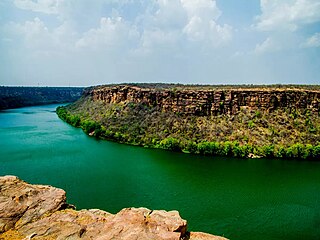
The Rihand River is a tributary of the Son River and flows through the Indian states of Chhattisgarh, Madhya Pradesh and Uttar Pradesh. Its old name was Renu or Renuka.

Mirzapur division, also sometimes known as Vindhyachal division, is one of the 18 administrative geographical units of the northern Indian state of Uttar Pradesh. Mirzapur city is the administrative headquarters. As of 2018, the division consists of 3 districts:-

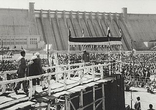
The Gandhi Sagar Dam is one of the four major dams built on India's Chambal River. The dam is located in the Mandsaur district of the state of Madhya Pradesh. It is a masonry gravity dam, standing 62.17 metres (204.0 ft) high, with a gross storage capacity of 7.322 billion cubic metres from a catchment area of 22,584 km2 (8,720 sq mi). The dam's foundation stone was laid by Prime Minister of India Pandit Jawaharlal Nehru on 7 March 1954, and construction of the main dam was done by leading contractor Dwarka Das Agrawal & Associates and was completed in 1960. Additional dam structures were completed downstream in the 1970s.

Nagarjuna Sagar Dam is a masonry dam across the Krishna River at Nagarjuna Sagar which straddles the border between Palnadu district in Andhra Pradesh and Nalgonda district in Telangana. The dam provides irrigation water to the districts of Krishna, Guntur, Palnadu, Prakasam and parts of West Godavari districts of Andhra Pradesh and also Nalgonda, Suryapet, Khammam, Bhadradri Kothagudem districts of Telangana. It is also a source of electricity generation for the national grid.
The Indira Sagar Dam is the largest dam in India, in terms of volume of water stored in the reservoir. It is located on the Narmada River at the town of Narmada Nagar, Punasa in the Khandwa district of Madhya Pradesh in India. The foundation stone of the project was laid by the prime minister of India Indira Gandhi on 23 October 1984. The construction of the main dam started in 1992. The downstream projects of ISP are Omkareshwar, Maheshwar, and Sardar Sarovar Project. To build it, a town of 22,000 people and 100 villages was displaced.

Robertsganj also known as Sonbhadra City is a city and a municipal board in Sonbhadra district in the Indian state of Uttar Pradesh.
Anpara is a town in Sonbhadra district in the state of Uttar Pradesh, India. It hosts an Anpara Thermal Power Station with a total installed capacity 3830MW. It is built beside Govind Ballabh Pant Sagar Lake and the Rihand River .. The pin code of Anpara is 231225. It lies on the plateau of Vindhya Range.
Bijpur is a census town part of Dudhi Tehsil in Sonbhadra district in the state of Uttar Pradesh, India.It is the border town located at UP - Madhya border.

Renukoot is a town and a nagar panchayat in Sonbhadra district in the Indian state of Uttar Pradesh. It is 68 km south from the district headquarters Robertsganj.

Sarni is a town located in the Betul District of Madhya Pradesh. It is administered by the Municipal Council of Sarni, which oversees the four contiguous settlements of Sarni, Pathakhera, Shobhapur Colony and Bagdona.

The Rana Pratap Sagar Dam is a gravity masonry dam of 53.8 metres (177 ft) height built on the Chambal River at Rawatbhata in Rajasthan in India. It is part of integrated scheme of a cascade development of the river involving four projects starting with the Gandhi Sagar Dam in the upstream reach in Madhya Pradesh and the Jawahar Sagar Dam on the downstream with a terminal structure of the Kota Barrage in Rajasthan for irrigation.
The Jawahar Sagar Dam is the third dam in the series of Chambal Valley Projects on the Chambal River, located 29 km upstream of Kota city and 26 km downstream of Rana Pratap Sagar dam. It is a concrete gravity dam, 45 meters high and 393 meters long, generating 60 MW of power with an installed capacity of 3 units of 33 MW. Its construction was completed in 1972. The dam's gross storage capacity is 67.07 million cubic meters. The total catchment area of the dam is 27,195 km2, of which only 1,496 km2 are in Rajasthan. The free catchment area below Rana Pratap Sagar dam is 2,331 km2. The dam is located after the Gandhi Sagar Dam and Rana Pratap Sagar Dam, but before the Kota Barrage.

Singrauli district is one of the districts in the Indian state of Madhya Pradesh. It is a significant hub for energy production due to its vast coal reserves and power plants, earning it the title "Energy Capital of India."
Rihand Dam also known as Govind Ballabh Pant Sagar, is the second largest dam of India by volume (storage) next only to Indirasagar Dam of Madhya Pradesh. The reservoir of Rihand Dam, called Govind Ballabh Pant Sagar, is India's largest artificial lake. Rihand Dam is a concrete gravity dam located at Pipri in Sonbhadra District in Uttar Pradesh, India. Its reservoir area is on the border of Madhya Pradesh and Uttar Pradesh. It is located on the Rihand River, a tributary of the Son River. The catchment area of this dam extends over Uttar Pradesh, Madhya Pradesh and Chhattisgarh states whereas it supplies irrigation water to Bihar located downstream of the river.

The Matatila Dam is a dam in district Lalitpur, Uttar Pradesh, India, that was built in 1958 on the Betwa River. Situated 50 km from Jhansi and 93 km away from Deogarh, this earthen dam is 35 m high. The dam has 23 Spillway gates. The catchment area is around 20 km2 with a maximum storage capacity of 1132 million cubic metres.
Rihand Nagar is a township, named after the Rihand River, a tributary of the Sone River. It is located near Bijpur and lies in the Sonebhadra district of Uttar Pradesh. This township is situated near the border of Uttar Pradesh and Madhya Pradesh in India. This township has been developed by National Thermal Power Corporation (NTPC) under its Power Project Scheme, wherein it established a coal-based power station of 3000 MW capacity.

Rihand Super Thermal Power Project is located at Renukut, Sonebhadra in Sonbhadra district in Indian state of Uttar Pradesh. The power plant is one of the coal based power plants of NTPC Limited.
Lakhwar-Vyasi Dam project on Yamuna River, includes under-construction Lakhwar Dam and Power Station, Vyasi Dam, Hathiari Power Station and Katapathar Barrage, near the Lakhwar town in Kalsi block of Dehradun district of Uttarakhand in India, for the purpose of irrigation of 40,000 hectare land and total 927 MW hydroelectric power generation. "Lakhwar Dam" is a gravity dam near the Lohari village with 300MW power generation capacity. "Vyasi Dam" will be built 5 km downstream along with 120 MW "Hathiari Power Station" further 0.5 km downstream. "Katapathar Barrage", with the maximum ponding water level at 514.5m elevation, will be built further 2.75 km downstream of the Hathiari Power Station to supply the water to stakeholder states. Project will hold 580 million cubic metres water during monsoon and release into Yamuna during dry months.
