Piramide (Rome Metro)

Last updated
Logo Metropolitane Italia.svg
Piramide
Roma - Stazione Metro B Piramide 2010-07-02.jpg
General information
Coordinates 41°52′32″N12°28′56″E / 41.87556°N 12.48222°E / 41.87556; 12.48222
Owned by ATAC
Connections Porta San Paolo railway station
Ostiense railway station
Construction
Structure typeAboveground
History
Opened10 February 1955;68 years ago (1955-02-10)
Services
Preceding station Logo Metropolitane Italia.svg Rome Metro Following station
Garbatella
towards Laurentina
Line B Circo Massimo
towards Rebibbia or Jonio
Location
Piramide (Rome Metro)
Click on the map to see marker

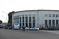
Piramide is a station on Line B of the Rome Metro. It was opened on 10 February 1955 and is sited on Piazzale Ostiense (across which is the Pyramid of Cestius that gives the station its name) just outside Porta San Paolo, in the Ostiense quarter. Its atrium houses mosaics that have won the Artemetro Roma by Enrico Castellani (Italy) and Beverly Pepper (United States). The station has escalators.

Contents

Beverley Pepper mosaic Metro B Piramide 1000101.JPG
Beverley Pepper mosaic

Connections

Alongside the Metro station is the Porta San Paolo station on the Ferrovia Roma-Lido. The Stazione Ostiense is connected to the metro station via an underpass - from here run the FR1, FR3 and FR5 mainline services.

Surroundings

Direction of traffic

Rioni and quarters

Monuments and churches

Related Research Articles

<span class="mw-page-title-main">Pyramid of Cestius</span> Ancient Roman pyramid, a landmark of Rome, Italy

The pyramid of Cestius is a Roman Era pyramid in Rome, Italy, near the Porta San Paolo and the Protestant Cemetery. It was built as a tomb for Gaius Cestius, a member of the Epulones religious corporation. It stands at a fork between two ancient roads, the Via Ostiensis and another road that ran west to the Tiber along the approximate line of the modern Via Marmorata. Due to its incorporation into the city's fortifications, it is today one of the best-preserved ancient buildings in Rome.

<span class="mw-page-title-main">Rome Metro</span> Rapid transit system in Rome, Italy

The Rome Metro is a rapid transit system that operates in Rome, Italy. It started operation in 1955, making it the oldest in the country.

<span class="mw-page-title-main">Ripa (rione of Rome)</span> Rione of Rome in Lazio, Italy

Ripa is the 12th rione of Rome, identified by the initials R. XII, and it is located in the Municipio I.

<span class="mw-page-title-main">Esquilino (rione of Rome)</span> Rione of Rome in Lazio, Italy

Esquilino is the 15th rione, or administrative division, of Rome, identified by the initials R. XV, and is Located within the Municipio I. It is named after the Esquiline Hill, one of the Seven Hills of Rome.

<span class="mw-page-title-main">Ludovisi (rione of Rome)</span> Rione of Rome in Lazio, Italy

Ludovisi is the 16th rione of Rome (Italy), identified by the initials R. XVI and located within the Municipio I.

<span class="mw-page-title-main">Celio (rione of Rome)</span> Rione of Rome in Lazio, Italy

Celio is the 19th rione of Rome, identified by the initials R. XIX, and is located within the Municipio I.

<span class="mw-page-title-main">Testaccio</span> Rione of Rome in Lazio, Italy

Testaccio is the 20th rione of Rome, identified by the initials R. XX, deriving its name from Monte Testaccio. It is located within the Municipio I.

<span class="mw-page-title-main">San Saba (rione of Rome)</span> Rione of Rome in Lazio, Italy

San Saba is the 21st rione of Rome, identified by the initials R. XXI. It is located within the Municipio I, and takes its name from the Basilica of San Saba, which is located there.

<span class="mw-page-title-main">Porta San Paolo</span> Gate of the Aurelian walls, a landmark of Rome, Italy

The Porta San Paolo is one of the southern gates in the 3rd-century Aurelian Walls of Rome, Italy. The Via Ostiense Museum is housed within the gatehouse. It is in the Ostiense quarter; just to the west is the Roman Pyramid of Cestius, an Egyptian-style pyramid, and beyond that is the Protestant Cemetery.

Piazza Albania is a square of Rome (Italy), placed along Viale Aventino, not far from Porta San Paolo, at the footsteps of the Aventine Hill.

<span class="mw-page-title-main">Rome–Lido railway</span>

The Roma–Lido railway is an urban railway line connecting the Porta San Paolo Station in Rome to Lido di Ostia, Rome's seaside neighborhood. The railway is 28.3 km (17.6 mi) long, stops at 13 stations and carries on average over 90,000 passengers per day.

<span class="mw-page-title-main">Circo Massimo (Rome Metro)</span> Rome metro station

Circo Massimo is a station on Line B of the Rome Metro. It was opened on 10 February 1955 and is sited at the east end of the Circus Maximus, after which it is named, near the headquarters of the FAO, originally built as the Ministero delle Colonie. Until 2002, the Obelisk of Axum also stood near the station. It has two separate exits on either side of the viale Aventino.

<span class="mw-page-title-main">Roma Ostiense railway station</span> Railway station in Rome, Italy

Roma Ostiense is a railway station in Piazza dei Partigiani serving the Ostiense district of Rome, Italy, a short distance from the Porta San Paolo. It is run by the Rete Ferroviaria Italiana arm of the Ferrovie dello Stato Italiane group and the urban rail lines FR1, FR3, and FR5 run through the station. It is linked with the Piramide Metro B station and the Roma Porta San Paolo station on the Rome-Lido railway line.

<span class="mw-page-title-main">Roma Porta San Paolo railway station</span>

Roma Porta San Paolo is the terminal train station of the Rome–Lido railway line in Rome (Italy). The station is connected to the station Piramide of the metro and to the Roma Ostiense railway station of the Ferrovie dello Stato Italiane. It has six tracks.

<span class="mw-page-title-main">Trams in Rome</span>

The current tram system in Rome, Italy, is a leftover from what once was the largest tram system in Italy. With its fragmented structure, it does not currently function as a backbone of the city's public transport. The system is owned and operated by Azienda Tranvie e Autobus del Comune di Roma.

<span class="mw-page-title-main">Municipio I</span> Municipio of Rome in Lazio, Italy

Municipio I is an administrative subdivision of the municipality of Rome, encompassing the centre of the city.

<span class="mw-page-title-main">Via Cristoforo Colombo</span>

Via Cristoforo Colombo is a street in Rome (Italy) that links the historic centre to Ostia. Along most of its route, the street has three lanes for each direction of movement. With its 27 kilometres (17 mi) length it is the longest Italian road among those included within the borders of a single municipality and, in several stretches, the largest in Italy.

<span class="mw-page-title-main">Ostiense</span> Quartiere of Rome in Lazio, Italy

Ostiense is the 10th quartiere of Rome, identified by the initials Q. X.

<span class="mw-page-title-main">ATAC SpA</span> Public Transport Society in Rome

ATAC S.p.A. is an Italian publicly owned company running most of the local public transportation services, paid parking and incentive parking lots in Rome. More specifically, the company handles, on behalf of Roma Capitale Authority, the entire tramway, trolleybus network and metro lines, as well as most of the bus lines in the city. It also operates, on behalf of the Administrative Region of Lazio, three railways: Roma-Civita Castellana-Viterbo, Roma-Giardinetti and Roma-Lido. ATAC S.p.A., with its 2,200-kilometer-wide public transport network, its over 8,500 busses and 70,000 parking stalls, is currently one of the biggest public transportation companies in Europe and the largest in Italy.

<span class="mw-page-title-main">Viale Aventino</span> Street in Rome, Italy

Viale Aventino is a street that links Piazza di Porta Capena and Piazza Albania in Rome (Italy). It marks the boundary between the Rione Ripa and San Saba.