Related Research Articles

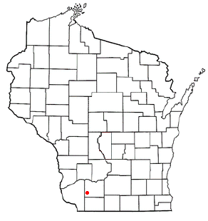
Mifflin is a town in Iowa County, Wisconsin, United States. The population was 617 at the 2000 census. The unincorporated community of Mifflin is located in the town. The extinct community of Dallas was located in the town.
Mount Pisgah is the name of several mountains and places:

Johnsonville is an unincorporated community located in Johnsonville Township, Harnett County, North Carolina, United States. It is located at the intersection of NC 24 and NC 27. It is a part of the Dunn Micropolitan Area, which is also a part of the greater Research Triangle of Raleigh–Durham–Cary-Chapel Hill Combined Statistical Area as defined by the United States Census Bureau.

Pineview is an unincorporated community located in the Barbecue Township of Harnett County, North Carolina, United States. It is a part of the Dunn Micropolitan Area, which is also a part of the greater Raleigh–Durham–Cary Combined Statistical Area (CSA) as defined by the United States Census Bureau.
Ryes is an unincorporated community located along old U.S. Route 421 in the Upper Little River Township of Harnett County, North Carolina, United States, situated between the communities of Seminole and Mamers. It is a part of the Dunn Micropolitan Area, which is also a part of the greater Raleigh–Durham–Cary Combined Statistical Area (CSA) as defined by the United States Census Bureau.
Seminole is an unincorporated community located along U.S. Route 421 in the Upper Little River Township of Harnett County, North Carolina, United States, near the county line with Lee County just outside the town of Broadway. It is a part of the Dunn Micropolitan Area, which is also a part of the greater Raleigh–Durham–Cary Combined Statistical Area (CSA) as defined by the United States Census Bureau.

Coleridge is an unincorporated community along the Deep River in Randolph County, North Carolina, United States. It lies near Ramseur and southeast of Greensboro. Major roads through the town are Highway 22, which is joined in the middle by Highway 42, which then travels to Bennett.This community was named for James A. Cole, a local merchant. It is in the Eastern Standard Time zone UTC-5. The elevation is 436 feet. Former and merged names include Foust's Mill.
The Pisgah phase is an archaeological phase of the South Appalachian Mississippian culture in Southeast North America. It is associated with the Appalachian Summit area of southeastern Tennessee, Western North Carolina, and northwestern South Carolina in what is now the United States.
Spring Creek is a tributary stream of the French Broad River in Madison County, North Carolina with a length of approximately 17 miles. It flows in much of its lower course through a section of the Pisgah National Forest and passes the communities of Trust, Luck, and Joe. It joins the French Broad river in Hot Springs, North Carolina.

Unaka National Forest was established by the U.S. Forest Service in North Carolina, Tennessee and Virginia on July 24, 1920, with 840,996 acres (3,403.39 km2). On July 10, 1936, most of the forest was transferred to Pisgah National Forest, with the Virginia portion going to Jefferson National Forest, and the name was discontinued.
Randolph Community College is a public community college in Randolph County, North Carolina. It is part of the North Carolina Community College System.
Windblow is an unincorporated crossroads community on the border of Montgomery and Richmond counties, North Carolina, United States. Located at the intersection of North Carolina Highway 73 and NC State Road 1003, Windblow is an agricultural community. Windblow is noted for its peach production; it is the namesake for the Winblo variety of peach. This particular peach, and many others, was developed at the Sandhills Research Station, a facility operated by North Carolina State University, one mile north of the crossroads. The community has a small grocery store and a trucking business in addition to the area farms.
Old Butt Knob is a summit in Haywood County, North Carolina, in the United States. It is located within Pisgah National Forest. With an elevation of 5,522 feet (1,683 m), Old Butt Knob is the 114th highest mountain in North Carolina.
Manly is an unincorporated community in Moore County, in the U.S. state of North Carolina.
Stono Mountain is a summit in St. Francois County in the U.S. state of Missouri. The mountain rises to an elevation of 1,644 feet (501 m). Mineral City lies along the headwaters of Doe Run Creek just to the east on Missouri Route W and Little Stono Mountain lies to the north.
Mount Pisgah is a small unincorporated community located on U.S. Highway 421 in the Grove Township, Harnett County, North Carolina. It is located between Buies Creek, North Carolina and Erwin, North Carolina. The community has an Erwin zip code of 28339. The area is a predominantly African American community dating to the Reconstruction era.
