Related Research Articles
Westmoreland County is a county in the Commonwealth of Pennsylvania, United States, located in the Pittsburgh Metropolitan Statistical Area. As of the 2020 census, the population was 354,663. The county seat is Greensburg and the most populous community is Hempfield Township. It is named after Westmorland, a historic county of England. The county is part of the Southwest Pennsylvania region of the state.
Somerset County is a county in the Commonwealth of Pennsylvania. As of the 2020 census, the population was 74,129. Its county seat is Somerset. The county was created from part of Bedford County on April 17, 1795, and named after the county of Somerset in England. The county is part of the Southwest Pennsylvania region of the state.

Fayette County is a county in the Commonwealth of Pennsylvania. It is located in southwestern Pennsylvania, adjacent to Maryland and West Virginia. As of the 2020 census, the population was 128,804. Its county seat is Uniontown. The county was created on September 26, 1783, from part of Westmoreland County and named after the Marquis de Lafayette. The county is part of the Southwest Pennsylvania region of the state.

South Fayette Township is a township in Allegheny County, Pennsylvania, United States. The population was 14,416 at the 2010 census.

South Versailles Township is a township in Allegheny County, Pennsylvania, United States. The population was 351 at the 2010 census. It contains the village of Coulter, also called Coulterville or Coulters. The U.S. Post Office in the village is called Coulters.

Rivesville is a town and former coal town in Marion County, West Virginia, United States. The population was 830 at the 2020 census.

Imperial is a census-designated place (CDP) in Allegheny County, Pennsylvania, United States and part of the Pittsburgh metropolitan area. The population was 2,722 at the 2020 census. The CDP is located in North Fayette and Findlay Townships, and geographically close to Pittsburgh International Airport.

Western Pennsylvania is a region in the Commonwealth of Pennsylvania encompassing the western third of the state. Pittsburgh is the region's principal city, with a metropolitan area population of about 2.4 million people, and serves as its economic and cultural center. Erie, Altoona, and Johnstown are its other metropolitan centers. As of the 2010 census, Western Pennsylvania's total population is nearly 4 million.

Yohogania County was created by the new state of Virginia in 1776, in an area long disputed between Virginia and Pennsylvania. The county ceased to exist after the border dispute between the two states was resolved in the 1780s. Thus, it is sometimes referred to as a "lost county," although 1.5 million people live within the territory it once claimed, which encompasses two entire counties and parts of four others in two states.

The Laurel Highlands is a region in southwestern Pennsylvania made up of Fayette County, Somerset County, and Westmoreland County. It has a population of about 600,000 people.

Greater Pittsburgh is the metropolitan area surrounding the city of Pittsburgh in Western Pennsylvania, United States. The region includes Allegheny County, Pittsburgh's urban core county and economic hub, and seven adjacent Pennsylvania counties: Armstrong, Beaver, Butler, Fayette, Lawrence, Washington, and Westmoreland in Western Pennsylvania, which constitutes the Pittsburgh, PA Metropolitan Statistical Area MSA as defined by the U.S. Office of Management and Budget.

A large metropolitan area that is surrounded by rivers and hills, Pittsburgh has an infrastructure system that has been built out over the years to include roads, tunnels, bridges, railroads, inclines, bike paths, and stairways; however, the hills and rivers still form many barriers to transportation within the city.
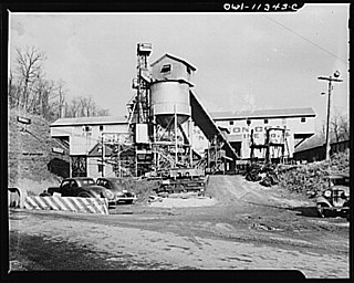
The Connellsville Coalfield is located in Fayette County and Westmoreland County, Pennsylvania, between the city of Latrobe and the small borough of Smithfield. It is sometimes known as the Connellsville Coke Field. This is because the section of the Pittsburgh coal seam here was famous as one of the finest metallurgical coals in the world. It is locally known as the Connellsville coal seam, but is a portion of the Pittsburgh seam.

Pennsylvania's 12th congressional district is located in southwestern Pennsylvania, including Pittsburgh and much of Allegheny County, as well as some of Westmoreland County. Since January 3, 2023, it has been represented by Summer Lee.

Pennsylvania's 18th congressional district was a district including the city of Pittsburgh and parts of surrounding suburbs. A variety of working class and majority black suburbs located to the east of the city were included, such as McKeesport and Wilkinsburg. Also a major part of the district was a number of middle class suburbs that have historic Democratic roots, such as Pleasant Hills and Penn Hills. The district became obsolete following the 2020 United States census. It was largely replaced by Pennsylvania's 12th congressional district.
The Keeling Coal Company (1861–1878) was a 19th-century coal mining company in Allegheny County, Pennsylvania. Its mines were located in the Pittsburgh Coalfield of western Pennsylvania.
The Pittsburgh Terminal Coal Company was a bituminous coal mining company based in Pittsburgh and controlled by the Mellon family. It operated mines in the Pittsburgh Coalfield, including mines in Becks Run and Horning, Pennsylvania. Unusually for that time in Pennsylvania, it hired African-American miners for some of its work.
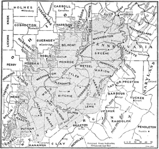
The Pittsburgh coal seam is the thickest and most extensive coal bed in the Appalachian Basin; hence, it is the most economically important coal bed in the eastern United States. The Upper Pennsylvanian Pittsburgh coal bed of the Monongahela Group is extensive and continuous, extending over 11,000 mi2 through 53 counties. It extends from Allegany County, Maryland to Belmont County, Ohio and from Allegheny County, Pennsylvania southwest to Putnam County, West Virginia.
The panhandle coalfield is a coalfield located in the northern panhandle of West Virginia counties of Hancock, Brooke, Ohio, Marshall, and Wetzel. Mining is primarily in the Pittsburgh coal seam, sometimes called the No. 8 seam, which is of a steam rather than metallurgical nature in this region. Currently CONSOL Energy maintains two large mines in this field - Shoemaker and McElroy. Also, the first new mine in Ohio County in forty years was being developed on Short Creek by Alliance Coal Co. in 2009.
The Morewood massacre was an armed labor-union conflict in Morewood, Pennsylvania, in Westmoreland County, west of the present-day borough Mount Pleasant in 1891.
References
- ↑ J. Peter Lesley (1887). Annual Report of the Geological Survey of Pennsylvania for 1885-1887. Original from the University of Michigan: Board of Commissioners for the Geological survey. p. 113.
monroeville coal mine.
- 1 2 3 "Pittsburgh Field". Coalfields of the Appalachian Mountains. Retrieved 2007-11-18.