
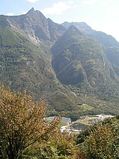
Lai da Sontga Maria is a lake, located north of the Lukmanier Pass in Switzerland. It lies almost entirely in the municipality of Medel, a tiny fraction of the south-west part of the lake belonging to the municipalities of Quinto and Blenio. The reservoir has a surface area is 1.77 km2 (0.68 sq mi). The arch dam Santa Maria was completed in 1968. The main road of the Lukmanier Pass runs along the eastern shore of the lake.

Pizzo Centrale is a mountain in the Lepontine Alps, located on the border between the cantons of Uri and Ticino. At 2,999 metres above sea level, it is the highest summit overlooking Gotthard Pass from the east. Lago della Sella is located on its southern side. Over its northern side lies a glacier, named Ober Schatzfirn.

Piz Medel is a mountain in the Lepontine Alps, located on the border between the cantons of Ticino and Graubünden. At 3,210 metres (10,531 ft) above sea level it is the highest summit on the chain between Lukmanier Pass and Crap la Crusch. The mountain overlooks the Greina, an important pass connecting the cantons of Graubünden and Ticino.

Pizzo di Cassimoi is a mountain of the Lepontine Alps, located on the border between the Swiss cantons of Ticino (west) and Graubünden (east). The mountain overlooks two lakes: Lago di Luzzone on its north-eastern side and Zervreilasee on its north-eastern side.

The Vogelberg is a 3,218 metres high mountain of the Lepontine Alps, located on the border between the Swiss cantons of Ticino and Graubünden. It is the highest summit of the Lepontine Alps south of the Rheinwaldhorn. The Vogelberg is a large glaciated massif consisting of several secondary summits: Pizzo Cramorino on the west side and Rheinquellhorn on the east. The northern flanks are covered by the Paradies Glacier at the source of the Hinterrhein. The southern side, overlooking the valley of Malvaglia (Ticino) is steeper and has no glaciers.

The Zapporthorn or Pizzo Zapport is a mountain of the Swiss Lepontine Alps, overlooking San Bernardino Pass in Graubünden. Its summit is the tripoint between the valleys of Hinterrhein, Calanca and Mesolcina. The summit is located approximately two kilometres east from the Ticino border.

Cima Rossa is a 3,161 metres high mountain in the Lepontine Alps, located on the border between the cantons of Ticino and Graubünden. On the west side it overlooks the valley of Malvaglia (Ticino) and on the east side it overlooks the valley of Calanca (Graubünden).

Piz di Strega is a mountain in the Lepontine Alps, overlooking Pass Giümela on the border between the cantons of Ticino and Graubünden. Its summit lies south of Pizzo di Ramulazz.

Piz Timun is a mountain of the Oberhalbstein Range, located on the border between Italy and Switzerland. On its eastern side it overlooks the artificial lake Lago di Lei.

Piz Lavirun is a mountain in the Livigno Range of the Alps, located on the border between Italy and Switzerland. It lies between the Val Lavirun (Graubünden) and the Valle di Federia (Lombardy).

The Madrisa is a mountain in the Rätikon mountain range, overlooking Klosters in the Swiss canton of Graubünden. Its summit is located near the Austrian border.
Pizzo d'Orsalia is a mountain of the Swiss Lepontine Alps, overlooking Bosco/Gurin in the canton of Ticino. It lies on the chain that separates the Val Calnègia from the Valle di Bosco/Gurin.
Pizzo Muncréch is a mountain in the Swiss Lepontine Alps, overlooking Malvaglia in the canton of Ticino. It is located west of Piz di Strega, between the valleys of Combra and Pontirone.
Pizzo Magn or Monte Crenone is a mountain of the Swiss Lepontine Alps, overlooking Biasca in the canton of Ticino. It is located west of the Mottone di Cava.

Tambohorn or Pizzo Tambo[ˈpittso ˈtambo] or Pizzo Tambò[ˈpittso tamˈbɔ] is a mountain located at the eastern extremity of the Lepontine Alps on the Swiss-Italian border. The mountain lies on the German-Italian language border, west of the Splügen Pass which divides the Western Alps from the Eastern Alps.

Pizzo del Ramulazz is a 2,939 metres high mountain in the Lepontine Alps, located on the border between the cantons of Ticino and Graubünden. The east side of the mountain, overlooking the Calanca valley, consists of a large and steep face.

The Chrüzlistock is a mountain of the Glarus Alps, located north of Sedrun on the border between the Swiss canton of Graubünden and Uri. The southern unnamed summit has an elevation of 2,717 metres (8,914 ft) and the northern summit, which is the named peak and is located on the cantonal border, has an elevation of 2,709 metres (8,888 ft).

Pizzo Paglia is a mountain of the Lepontine Alps, overlooking the Val Cama in the canton of Graubünden. The border with Italy runs 300 metres south of the summit.
Pizzo di Zocca is a mountain of the Bregaglia Range, located on the border between Switzerland and Italy. Its summit lies between the valleys of Albigna and Val di Mello.
Piz Vatgira is a mountain of the Lepontine Alps and part of the extended Saint-Gotthard Massif, located south of Sedrun in the canton of Graubünden. The mountain lies between the valleys of Nalps and Medel, about halfway between Lai da Nalps and Lai da Sontga Maria. On its east side is a small glacier ending in the lake named Lai Verd.


