Place Farm, Tisbury

Last updated

Place Farm
Place Farm - Tisbury - geograph.org.uk - 707336.jpg
"One of the finest surviving groups of monastic grange buildings in England"
TypeFarm
Location Tisbury, Wiltshire
Coordinates 51°04′04″N2°04′16″W / 51.0678°N 2.0712°W / 51.0678; -2.0712
Built14th century and after
Governing body Fonthill Estate
Listed Building – Grade I
Official namePlace Farmhouse
Designated6 January 1966
Reference no.1184177
Listed Building – Grade I
Official nameInner gatehouse at Place Farm
Designated6 January 1966
Reference no.1146019
Listed Building – Grade I
Official nameOuter gatehouse at Place Farm
Designated6 January 1966
Reference no.1300237
Listed Building – Grade I
Official nameTithe barn at Place Farm
Designated6 January 1966
Reference no.1318824
Listed Building – Grade II
Official nameFarm buildings at Place Farm
Designated6 January 1966
Reference no.1146020
Wiltshire UK location map.svg
Red pog.svg
Location of Place Farm in Wiltshire

Place Farm is a complex of medieval buildings in the village of Tisbury, Wiltshire, England. They originally formed a grange of Shaftesbury Abbey. The farmhouse, the inner and outer gatehouses and the barn, reputedly the largest in England, are all Grade I listed buildings.

Contents

History and description

Shaftesbury Abbey was founded by Alfred the Great in 888. The first religious foundation established for women in England, Alfred's daughter, Æthelgifu was installed as abbess. [1] By the Middle Ages, the abbey had become a very wealthy institution, and it established the grange at Place Farm as the administrative centre of its Wiltshire estates. [lower-alpha 1] [2] Nikolaus Pevsner, in his Wiltshire Pevsner, dates the buildings at Place Farm to the 14th and 15th centuries. [3] Anthony Quiney describes the "magnificent scale" of the complex. [4] The Victoria County History notes that the ancillary features included two chapels, two larder houses, stables, houses for oxen, hay, and charcoal, and a number of fishponds. [5] Margaret Wood, in her history, The Medieval English House, wrote that although the gatehouses are not properly defensive in a military sense, they would provide protection "against bands of marauders or discontented peasantry". [6] At the Dissolution of the Monasteries in 1536 Place Farm passed into private ownership. In the 19th century, the farm became part of the Fonthill estate of the Morrison family, who continue in ownership. [7] The tithe barn is let to Messum's, the art dealers, [8] while other farm buildings are occupied by the charity, International Cat Care. [9]

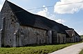
The farm house at Place Farm is a Grade I listed building. Dating mainly from the 15th century, it was renovated in the 19th. It is constructed of rubble stone, with a tiled roof. A room in the house has a frieze which carries the initials AM, that probably reference the collector Alfred Morrison who owned the estate in the 19th century. [10] The estate buildings which form three sides of a courtyard are listed Grade II. [11] The tithe barn, which at 200ft long is reputed to be the largest barn in England, [3] [12] has a Grade I listing. [13] The barn was originally tiled, but now has a thatched roof, [lower-alpha 2] which was renewed in 1971. [3] The barn is thirteen bays long, with a cruck truss roof structure. [13] The inner and outer gatehouses are also listed at Grade I. [14] [15] Historic England considers the complex at Place Farm, "one of the finest surviving groups of monastic grange buildings in England". [13]

Footnotes

  1. A popular contemporary saying suggested that Shaftesbury's wealth, and that of the neighboring abbey of Glastonbury, was such that, "If the abbot of Glastonbury could marry the abbess of Shaftesbury their heir would hold more land than the king of England". [2]
  2. Alec Clifton-Taylor, the architectural historian, calculated the roof required 1,450 square yards of thatch. [3] John Julius Norwich noted the "heroical" scale of the effort required to undertake the thatching. [12]

Related Research Articles

<span class="mw-page-title-main">Lacock</span> Village in Wiltshire, England

Lacock is a village and civil parish in the county of Wiltshire, England, about 3 miles (5 km) south of the town of Chippenham, and about 3.7 miles (6.0 km) outside the Cotswolds area. The village is owned almost in its entirety by the National Trust and attracts many visitors by virtue of its unspoiled appearance.

<span class="mw-page-title-main">Avebury (village)</span> Village and civil parish in Wiltshire, England

Avebury is a village and civil parish in Wiltshire, England. The village is about 5.5 miles (9 km) west of Marlborough and 8 miles (13 km) northeast of Devizes. Much of the village is encircled by the prehistoric monument complex also known as Avebury. The parish also includes the small villages of Avebury Trusloe and Beckhampton, and the hamlet of West Kennett.

<span class="mw-page-title-main">Baydon</span> Human settlement in England

Baydon is a village and civil parish in Wiltshire, England about 10 miles (16 km) south-east of Swindon. The eastern boundary of the parish forms part of the county boundary with Berkshire, and the village is about 7 miles (11 km) north-west of the West Berkshire market town of Hungerford.

<span class="mw-page-title-main">Donhead St Mary</span> Human settlement in England

Donhead St Mary is a village and civil parish in southwest Wiltshire, England, on the county border with Dorset. The village lies about 2+12 miles (4.0 km) east of the Dorset town of Shaftesbury and stands on high ground above the River Nadder, which rises in the parish.

<span class="mw-page-title-main">Ansty, Wiltshire</span> Human settlement in England

Ansty is a small village and civil parish in southwest Wiltshire, England, about 6 miles (10 km) east of Shaftesbury. The village is just north of the A30, between Shaftesbury and Salisbury. The parish includes the hamlet of Ansty Coombe.

<span class="mw-page-title-main">Atworth</span> Human settlement in England

Atworth is a village and civil parish in west Wiltshire, England. The village is on the A365 road between Melksham and Box, about 2.5 miles (4 km) northwest of Melksham and 4 miles (6 km) northeast of Bradford on Avon. The hamlet of Purlpit lies east of Atworth village, and in the south of the parish are the small village of Great Chalfield and the hamlet of Little Chalfield.

<span class="mw-page-title-main">Berwick St Leonard</span> Human settlement in England

Berwick St Leonard is a small village and civil parish in Wiltshire, England, about 8 miles (13 km) southeast of Warminster and 14 miles (23 km) west of Salisbury.

<span class="mw-page-title-main">Brokenborough</span> Human settlement in England

Brokenborough is a village and civil parish about 1+12 miles (2.4 km) northwest of Malmesbury, Wiltshire in England. The course of the Fosse Way Roman road forms the northwest boundary of the parish, and also the county boundary with neighbouring Gloucestershire. The Tetbury Avon, also called the Ingleburn, flows through the parish west of the village. The 2021 Census recorded the parish's population as 186. The village forms part of the ecclesiastical parish of Malmesbury and Brokenborough, in the Diocese of Bristol.

<span class="mw-page-title-main">Tisbury, Wiltshire</span> Human settlement in England

Tisbury is a large village and civil parish approximately 13 miles (21 km) west of Salisbury in the English county of Wiltshire. With a population at the 2011 census of 2,253 it is a centre for communities around the upper River Nadder and Vale of Wardour. The parish includes the hamlets of Upper Chicksgrove and Wardour.

<span class="mw-page-title-main">Great Coxwell Barn</span> Medieval tithe barn in Great Coxwell, Oxfordshire, England

Great Coxwell Barn is a Medieval tithe barn at Great Coxwell, Oxfordshire, England. It is on the northern edge of the village of Great Coxwell, which is about 9 miles (14 km) northeast of Swindon in neighbouring Wiltshire.

<span class="mw-page-title-main">Pythouse</span> Building in Wiltshire, England

Pythouse, sometimes spelled Pyt House and pronounced pit-house, is a country house in southwest Wiltshire, in the west of England. It is about 2+12 miles (4.0 km) west of the village of Tisbury.

Mendip is a local government district in the English county of Somerset. The Mendip district covers a largely rural area of 285 square miles (738 km2) ranging from the Mendip Hills through on to the Somerset Levels. It has a population of approximately 11,000. The administrative centre of the district is Shepton Mallet.

<span class="mw-page-title-main">South Wraxall</span> Human settlement in England

South Wraxall is a village and a civil parish in Wiltshire, England, 2.5 miles (4.0 km) north of Bradford on Avon. The village is to the east of the B3109 road from Bradford on Avon to Corsham.

<span class="mw-page-title-main">Semley</span> Human settlement in England

Semley is a village and former civil parish, now in the parish of Sedgehill and Semley, in Wiltshire, England, about 3 miles (4.8 km) north-east of Shaftesbury in neighbouring Dorset. The hamlet of Sem Hill lies about a quarter of a mile west of the village. In 1961 the parish had a population of 477.

<span class="mw-page-title-main">Teffont Magna</span> Human settlement in England

Teffont Magna, sometimes called Upper Teffont, is a small village and former civil parish, now in the parish of Teffont, in the Nadder valley in the south of the county of Wiltshire, England. For most of its history, Teffont Magna was a chapelry of neighbouring Dinton. In 1934 it was combined with the parish of Teffont Evias, just to the south, to form a united Teffont parish.

<span class="mw-page-title-main">Bradford-on-Avon Tithe Barn</span>

Bradford-on-Avon Tithe Barn is a Grade I listed barn in Pound Lane, Bradford on Avon, Wiltshire, England. It was part of a medieval grange belonging to Shaftesbury Abbey and was built in the early 14th century, with a granary dated to about 1400. It is owned and protected by English Heritage and managed by the Bradford on Avon Preservation Trust.

Bickerstaffe is a civil parish in the West Lancashire district of Lancashire, England. It contains twelve listed buildings that are recorded in the National Heritage List for England. All of the listed buildings are designated at Grade II, the lowest of the three grades, which is applied to "buildings of national importance and special interest". The parish contains the village of Bickerstaffe and the hamlet of Barrow Nook, and is otherwise rural. The listed buildings include houses, farmhouses and farm buildings, a church, structures associated with the Friends' Burial Ground, a converted windmill, a boundary stone, stocks, and a war memorial.

Mavesyn Ridware is a civil parish in the district of Lichfield, Staffordshire, England. It contains 24 listed buildings that are recorded in the National Heritage List for England. Of these, two are at Grade I, the highest of the three grades, three are at Grade II*, the middle grade, and the others are at Grade II, the lowest grade. The parish contains the villages of Hill Ridware and Mavesyn Ridware and smaller settlements, and the surrounding countryside. Most of the listed buildings are houses, cottages, farmhouses and farm buildings, the earlier of which are timber framed, some with cruck construction. The other listed buildings include a church and a memorial in the churchyard, larger houses with associated structures, including a gatehouse, and a bridge.

<span class="mw-page-title-main">Wigmore Abbey Grange</span> Grade I listed structure in Herefordshire, United Kingdom

Wigmore Abbey Grange is a complex of former monastic buildings just north of the village of Adforton, Herefordshire, England.

Greasley is a civil parish in the Borough of Broxtowe, Nottinghamshire, England. The parish contains 30 listed buildings that are recorded in the National Heritage List for England. Of these, two are listed at Grade II*, the middle of the three grades, and the others are at Grade II, the lowest grade. The parish contains the settlements of Beauvale, Moorgreen and Watnall and the surrounding area. Most of the listed buildings are houses, cottages and associated structures, farmhouses and farm buildings. The others include the remains of a fortified manor house, a church and a former chapel, and a school.

References

  1. "The Abbey Church of St Mary and St Edward, King and Martyr: History". Shaftesbury Abbey Museum & Gardens. Retrieved 30 August 2020.
  2. 1 2 "House of Benedictine nuns: The abbey of Shaftesbury". www.british-history.ac.uk. British History Online. Retrieved 30 August 2020.
  3. 1 2 3 4 Pevsner & Cherry 2002, p. 523.
  4. Quiney 1990, p. 162.
  5. Freeman, Jane; Stevenson, Janet (1987). Crowley, D.A. (ed.). "Victoria County History – Wiltshire – Vol 13 pp195-248: Tisbury". British History Online. University of London. Retrieved 30 August 2020.
  6. Wood 1994, p. 156.
  7. "History". The Fonthill Estate. Retrieved 30 August 2020.
  8. "Messums Wiltshire - Gallery and Arts Centre". Messums Wiltshire. Retrieved 30 August 2020.
  9. "International Cat Care". icatcare.org. ICC. Retrieved 30 August 2020.
  10. Historic England. "Place Farmhouse (Grade I) (1184177)". National Heritage List for England . Retrieved 30 August 2020.
  11. Historic England. "Farm buildings at Place Farm (Grade II) (1146020)". National Heritage List for England. Retrieved 30 August 2020.
  12. 1 2 Norwich 1985, p. 682.
  13. 1 2 3 Historic England. "Tithe barn at Place Farm (Grade I) (1318824)". National Heritage List for England. Retrieved 30 August 2020.
  14. Historic England. "Inner gatehouse at Place Farm (Grade I) (1146019)". National Heritage List for England. Retrieved 30 August 2020.
  15. Historic England. "Outer gatehouse at Place Farm (Grade I) (1300237)". National Heritage List for England. Retrieved 30 August 2020.

Sources