
El Dorado County, officially the County of El Dorado, is a county located in the U.S. state of California. As of the 2020 census, the population was 191,185. The county seat is Placerville. The county is part of the Sacramento-Roseville-Arden-Arcade, CA Metropolitan Statistical Area. It is located entirely in the Sierra Nevada, from the historic Gold Country in the western foothills to the High Sierra in the east. El Dorado County's population has grown as Greater Sacramento has expanded into the region. Where the county line crosses US 50 at Clarksville, the distance to Sacramento is 15 miles. In the county's high altitude eastern end at Lake Tahoe, environmental awareness and environmental protection initiatives have grown along with the population since the 1960 Winter Olympics, hosted at the former Squaw Valley Ski Resort in neighboring Placer County.

Placerville is a city in and the county seat of El Dorado County, California. The population was 10,747 as of the 2020 census, up from 10,389 as of the 2010 census. It is part of the Sacramento–Arden-Arcade–Roseville Metropolitan Statistical Area.
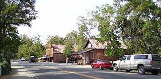
Coloma is a census-designated place in El Dorado County, California, US. It is approximately 36 miles (58 km) northeast of Sacramento, California. Coloma is most noted for being the site where James W. Marshall found gold in the Sierra Nevada foothills, at Sutter's Mill on January 24, 1848, leading to the California Gold Rush. Coloma's population is 529.

U.S. Route 50 (US 50) is a transcontinental United States Numbered Highway, stretching from West Sacramento, California, in the west to Ocean City, Maryland, in the east. The California portion of US 50 runs east from Interstate 80 (I-80) in West Sacramento to the Nevada state line in South Lake Tahoe. A portion in Sacramento also has the unsigned designation of Interstate 305. The western half of the highway in California is a four-or-more-lane divided highway, mostly built to freeway standards, and known as the El Dorado Freeway outside of downtown Sacramento. US 50 continues as an undivided highway with one eastbound lane and two westbound lanes until the route reaches the canyon of the South Fork American River at Riverton. The remainder of the highway, which climbs along and out of the canyon, then over the Sierra Nevada at Echo Summit and into the Lake Tahoe Basin, is primarily a two-lane road.
Elk Grove High School is a public four-year high school located in Elk Grove, California, in the United States. It is part of the Elk Grove Unified School District and serves the southeast end of Elk Grove that is to the right of California State Route 99 and below Sheldon Road.
Fresh Pond is a small unincorporated community in El Dorado County, California. It is located 3 miles (4.8 km) east of Pollock Pines, at an elevation of 3606 feet. The ZIP code is 95726. The community is inside area code 530.
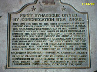
Congregation B'nai Israel is a Reform Jewish congregation and synagogue, located at 3600 Riverside Boulevard, in Sacramento, California, in the United States. Founded in 1852 as an Orthodox community, the congregation is the oldest Jewish congregation in Sacramento. The congregation dates the California Gold Rush of 1849, when Jewish settlers gathered to observe the High Holy days. The congregation purchased its first building at 7th and L streets on September 2, 1852, making it the first synagogue west of the Mississippi River.
Clarksville is an unincorporated community in El Dorado County, California. It is located 14 miles (23 km) west-southwest of Placerville, at an elevation of 676 feet.
Gold Hill is an unincorporated community in El Dorado County, California. It is located 2.5 miles (4.0 km) south of Coloma, at an elevation of 1621 feet.
Outingdale is an unincorporated community in El Dorado County, California. It is located on the Middle Fork of the Cosumnes River 4 miles (6.4 km) north of Aukum, at an elevation of 1624 feet.

The Sacramento Historic City Cemetery, located at 1000 Broadway, at 10th Street, is the oldest existing cemetery in Sacramento, California. It was designed to resemble a Victorian garden and sections that are not located in level areas are surrounded by brick or concrete retaining walls to create level terraces. The cemetery grounds are noted for their roses which are said to be among the finest in California.
Samuel Altshuler was a clothing merchant, mine owner, and industrial developer in the states of Washington and California. He opened and owned clothing stores in Whatcom, Washington, and his native San Francisco, California, and built several business buildings in both cities.

The Sonora Hebrew Cemetery, also known as Pioneer Jewish Cemetery, is an inactive Jewish cemetery founded in c. 1851, and located in Sonora, California. This was the first Jewish cemetery in the Gold Rush region.
Marysville Hebrew Cemetery also known as Marysville Jewish Cemetery, and Jewish Cemetery of Marysville, is a no longer active Jewish cemetery founded in 1855 by the Marysville Hebrew Benevolent Society, and is located at the southeast corner of Marysville Cemetery, in Marysville, California. In 1945, the cemetery was abandoned and forgotten; by 1995 it was restored.
The Marin Society of Artists (MSA) is an arts nonprofit 501(c)(3) organization founded in 1927, and located at 1515 3rd Street in San Rafael, California. It is the first and the oldest art organization in Marin County. Formerly known as the Marin Art Association, and formerly part of the Marin Arts and Garden Center.
Nevada City Jewish Cemetery is a no longer active Jewish cemetery founded in 1854 by the Nevada Hebrew Society, and located in Nevada City, Nevada County, California. The last burial was during the summer of 1890. There are only 29 headstones that are visible. On October 29, 1972, the site was dedicated as a historical site.
Chevra Kaddisha Cemetery, later known as Home of Peace Cemetery, was the first Jewish cemetery in California founded on November 12, 1850, by the Sacramento City Hebrew Association, and was once located at 33rd at K Streets in the East Sacramento neighborhood of Sacramento, California. The cemetery closed around 1924, and is no longer standing. It is the location of a strip mall, there is no historical plaque.
The Home of Peace Cemetery is a Jewish cemetery founded in 1924, and located at 6200 Stockton Boulevard in Sacramento, California. This cemetery contains some of the earliest Jewish gravestones in the western United States, moved from Chevra Kaddisha Cemetery.
Grass Valley Pioneer Jewish Cemetery, also known as Shaar Zedek is a no longer active Jewish cemetery founded in 1856 by the Hebrew Benevolent of Society of Grass Valley, and is located in Grass Valley, California, U.S. The last burial happened in 1891. It is a private site operated by the Commission for the Preservation of Pioneer Jewish Cemeteries and Landmarks in the West and is not open to the public.
