
An aquifer is an underground layer of water-bearing permeable rock, rock fractures or unconsolidated materials.

Center-pivot irrigation, also called water-wheel and circle irrigation, is a method of crop irrigation in which equipment rotates around a pivot and crops are watered with sprinklers. A circular area centered on the pivot is irrigated, often creating a circular pattern in crops when viewed from above. Most center pivots were initially water-powered, however today most are propelled by electric motors.

Geothermal energy is the thermal energy in the Earth's crust which originates from the formation of the planet and from radioactive decay of materials in currently uncertain but possibly roughly equal proportions. The high temperature and pressure in Earth's interior cause some rock to melt and solid mantle to behave plastically. This results in parts of the mantle convecting upward since it is lighter than the surrounding rock. Temperatures at the core–mantle boundary can reach over 4000 °C (7200 °F).

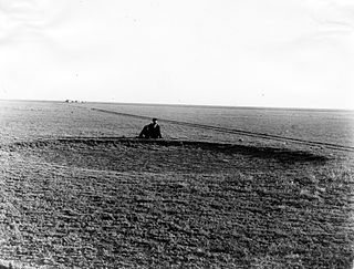
The Ogallala Aquifer is a shallow water table aquifer surrounded by sand, silt, clay, and gravel located beneath the Great Plains in the United States. One of the world's largest aquifers, it underlies an area of approximately 174,000 sq mi (450,000 km2) in portions of eight states. It was named in 1898 by geologist N. H. Darton from its type locality near the town of Ogallala, Nebraska. The aquifer is part of the High Plains Aquifer System, and resides in the Ogallala Formation, which is the principal geologic unit underlying 80% of the High Plains.

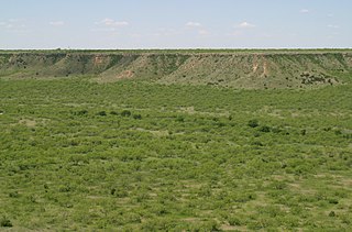
Palo Duro Canyon is a canyon system of the Caprock Escarpment located in the Texas Panhandle near the cities of Amarillo and Canyon. As the second-largest canyon in the United States, it is roughly 120 mi (190 km) long and has an average width of 6 mi (9.7 km), but reaches a width of 20 mi (32 km) at places. Its depth is around 820 ft (250 m), but in some locations, it increases to 1,000 ft (300 m). Palo Duro Canyon has been named "The Grand Canyon of Texas" both for its size and for its dramatic geological features, including the multicolored layers of rock and steep mesa walls, which are similar to those in the Grand Canyon. It is part of Palo Duro Canyon State Park.

The Llano Estacado, sometimes translated into English as the Staked Plains, is a region in the Southwestern United States that encompasses parts of eastern New Mexico and northwestern Texas. One of the largest mesas or tablelands on the North American continent, the elevation rises from 3,000 feet (900 m) in the southeast to over 5,000 feet (1,500 m) in the northwest, sloping almost uniformly at about 10 feet per mile (1.9 m/km).
Fossil water or paleowater is an ancient body of water that has been contained in some undisturbed space, typically groundwater in an aquifer, for millennia. Other types of fossil water can include subglacial lakes, such as Antarctica's Lake Vostok, and even ancient water on other planets.
The High Plains are a subregion of the Great Plains, mainly in the Western United States, but also partly in the Midwest states of Nebraska, Kansas, and South Dakota, generally encompassing the western part of the Great Plains before the region reaches the Rocky Mountains. The High Plains are located in eastern Montana, southeastern Wyoming, southwestern South Dakota, western Nebraska, eastern Colorado, western Kansas, eastern New Mexico, western Oklahoma, and to just south of the Texas Panhandle. The southern region of the Western High Plains ecology region contains the geological formation known as Llano Estacado which can be seen from a short distance or on satellite maps. From east to west, the High Plains rise in elevation from around 1,800 to 7,000 feet.
The Floridan aquifer system, composed of the Upper and Lower Floridan aquifers, is a sequence of Paleogene carbonate rock which spans an area of about 100,000 square miles (260,000 km2) in the southeastern United States. It underlies the entire state of Florida and parts of Alabama, Georgia, Mississippi, and South Carolina.

The Edwards Aquifer is one of the most prolific artesian aquifers in the world. Located on the eastern edge of the Edwards Plateau in the U.S. state of Texas, it is the source of drinking water for two million people, and is the primary water supply for agriculture and industry in the aquifer's region. Additionally, the Edwards Aquifer feeds the Comal and San Marcos springs, provides springflow for recreational and downstream uses in the Nueces, San Antonio, Guadalupe, and San Marcos river basins, and is home to several unique and endangered species.

Cotton Center is an unincorporated community in western Hale County, Texas, United States, located about 12 miles southwest of Hale Center. Until the late 19th century, the Comanche tribe of Native Americans occupied the area. In 1907, with the coming of a branch of the Santa Fe Railroad, a number of farming operations were established. Cotton Center was originally created in 1925 as a consolidated school district, with a small unincorporated community site, containing the school, cotton gins, and various businesses to support the surrounding farms. In 1935, a local post office opened, and the first irrigation well was drilled. By the late 1940s, irrigation wells proliferated, pumping water from the Ogallala Aquifer. The community revolves around farming and is tied together by the school, which as of 2005 had 140 students in prekindergarten through grade 12.

The potential for exploiting geothermal energy in the United Kingdom on a commercial basis was initially examined by the Department of Energy in the wake of the 1973 oil crisis. Several regions of the country were identified, but interest in developing them was lost as petroleum prices fell. Although the UK is not actively volcanic, a large heat resource is potentially available via shallow geothermal ground source heat pumps, shallow aquifers and deep saline aquifers in the mesozoic basins of the UK. Geothermal energy is plentiful beneath the UK, although it is not readily accessible currently except in specific locations.

The Texas High Plains AVA is an American Viticultural Area located on the Llano Estacado region of Texas. The appellation is the second largest American Viticultural Area in Texas, and covers an area of over 270,000 acres (422 sq mi). Most of the vineyards are on flat terrain at elevations between 3,000 feet (914 m) and 4,000 feet (1,219 m) above sea level. The Texas plains can be extremely dry, so most vineyards are irrigated with water from the Ogallala Aquifer. The hardiness zones are 7a and 7b.
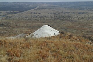
Mount Blanco is a small white hill — an erosional remnant — located on the eastern border of the Llano Estacado within Blanco Canyon in Crosby County, Texas. With Blanco Canyon, it is the type locality of the Blanco Formation of Texas and Kansas, as well as the Blancan fauna, which occurs throughout North America.
The White River is an intermittent stream in the South Plains of Texas and a tributary of the Brazos River of the United States. It rises 8 miles (13 km) west of Floydada in southwestern Floyd County at the confluence of Callahan and Runningwater Draws. From there, it runs southeast for 62 miles (100 km) to its mouth on the Salt Fork of the Brazos River in northwestern Kent County. Besides these two headwaters, which rise near Hale Center and in Curry County, New Mexico, respectively, other tributaries include Pete, Crawfish, and Davidson Creeks. The White River drains an area of 1,690 sq mi (4,377 km2).
Tierra Blanca Creek is an ephemeral stream about 75 mi (121 km) long, heading in Curry County, New Mexico, flowing east-northeast across northern portions of the Llano Estacado to join Palo Duro Creek to form the Prairie Dog Town Fork Red River southeast of Amarillo, Texas. Overall, Tierra Blanca Creek descends 1,050 ft (320 m) from its headwaters in Eastern New Mexico to its confluence with Palo Duro Creek at the head of Palo Duro Canyon.

Yellow House Draw is an ephemeral watercourse about 236 km (147 mi) long, heading about 20 km (12 mi) southwest of Melrose, New Mexico, and tending generally east-southeastward across the Llano Estacado to the city of Lubbock, where it joins Blackwater Draw to form Yellow House Canyon at the head of the North Fork Double Mountain Fork Brazos River. It stretches across Roosevelt, Curry, Bailey, Cochran, Hockley, and Lubbock Counties of eastern New Mexico and West Texas, and drains an area of 9,790 km2 (3,780 sq mi).

Becton is an unincorporated community in northeast Lubbock County, about 18 mi (29 km) northeast of Lubbock, Texas. This small rural community lies on the high plains of the Llano Estacado in West Texas.

Close City is an unincorporated community in western Garza County, about 6.5 mi (10.5 km) west-northwest of Post, Texas. The small rural community lies on the High Plains of the Llano Estacado in West Texas.

The Ogallala Formation is a Miocene to early Pliocene geologic formation in the central High Plains of the western United States and the location of the Ogallala Aquifer. In Nebraska and South Dakota it is also classified as the Ogallala Group. Notably, it records the North American Land Mammal Ages (NALMAs) Hemphillian, Clarendonian, and Barstovian. It also includes an excellent record of grass seeds and other plant seeds, which can be used for biostratigraphic dating within the formation. The Ogallala Formation outcrops of Lake Meredith National Recreation Area preserve fish fossils. Similar specimens from the same unit are found at Alibates Flint Quarries National Monument in Texas.

