Plaza San Martín (Lima)

Last updated
View of the Plaza San Martin from the Bolivar Hotel San Martin Plaza.jpg
View of the Plaza San Martín from the Bolívar Hotel

The Plaza San Martín is one of the most representative public spaces of the city of Lima, Peru. It is located at the ninth block of Colmena avenue, within the Historic Centre of Lima which was declared a World Heritage Site in 1988 by UNESCO. It is located near the Plaza Mayor of Lima and is connected to it by the Jiron de la Union. Its central monument gives homage to Peru's liberator, José de San Martín.

Public space places for public use

A public space is a place that is generally open and accessible to people. Roads, public squares, parks and beaches are typically considered public space. To a limited extent, government buildings which are open to the public, such as public libraries are public spaces, although they tend to have restricted areas and greater limits upon use. Although not considered public space, privately owned buildings or property visible from sidewalks and public thoroughfares may affect the public visual landscape, for example, by outdoor advertising. Recently, the concept of Shared space has been advanced to enhance the experience of pedestrians in public space jointly used by automobiles and other vehicles.

Lima Capital city in Peru

Lima is the capital and the largest city of Peru. It is located in the valleys of the Chillón, Rímac and Lurín rivers, in the central coastal part of the country, overlooking the Pacific Ocean. Together with the seaport of Callao, it forms a contiguous urban area known as the Lima Metropolitan Area. With a population of more than 9 million, Lima is the most populous metropolitan area of Peru and the third-largest city in the Americas, behind São Paulo and Mexico City.

Peru republic in South America

Peru, officially the Republic of Peru, is a country in western South America. It is bordered in the north by Ecuador and Colombia, in the east by Brazil, in the southeast by Bolivia, in the south by Chile, and in the west by the Pacific Ocean. Peru is a megadiverse country with habitats ranging from the arid plains of the Pacific coastal region in the west to the peaks of the Andes mountains vertically extending from the north to the southeast of the country to the tropical Amazon Basin rainforest in the east with the Amazon river.

Contents

History

Monument to Jose de San Martin San Martin - Statue.jpg
Monument to José de San Martín

Precedents

The location of the plaza had been the site of the San Juan de Dios hospital which was torn down in 1850 and replaced by a railway station, which in turn was torn down between 1911 and 1918.

Construction

The Plaza San Martín was inaugurated on July 27, 1921 in celebration of the 100th anniversary of the independence of Peru. The design, ornamentation, furnishing, and gardening of the plaza was designed by Manuel Piqueras Cotolí. The benches and handrails were constructed out of marble and the paving, of granite. There were also four water fountains, bronze streetlamps, and flower-filled gardens. The design for the monument to José de San Martín was chosen in an contest in which the design created by the Spanish sculptor Mariano Benlliure emerged victorious and illustrated San Martin during his voyage across the Andes.

Peruvian War of Independence armed conflict in Peru between 1811 and 1824

The Peruvian War of Independence was composed of a series of military conflicts in Peru beginning with viceroy Abascal military reconquest in 1811 in the battle of Guaqui, continuing with the definitive defeat of the Spanish Army in 1824 in the battle of Ayacucho, and culminating in 1826 with the Siege of Callao. The wars of independence took place with the background of the 1780–1781 uprising by indigenous leader Túpac Amaru II and the earlier removal of Upper Peru and the Río de la Plata regions from the Viceroyalty of Peru. Because of this the viceroy often had the support of the "Lima oligarchy," who saw their elite interests threatened by popular rebellion and were opposed to the new commercial class in Buenos Aires. During the first decade 1800s Peru had been a stronghold for royalists, who fought those in favor of independence in Peru, Bolivia, Quito and Chile. Among the most important events during the war was the proclamation of independence of Peru by José de San Martín on 28 July 1821.

José de San Martín Argentine general and independence leader

José Francisco de San Martín y Matorras, known simply as José de San Martín or El Libertador of Argentina, Chile and Peru, was a Spanish-Argentine general and the prime leader of the southern and central parts of South America's successful struggle for independence from the Spanish Empire who served as the Protector of Peru. Born in Yapeyú, Corrientes, in modern-day Argentina, he left his mother country at the early age of seven to study in Málaga, Spain.

An architectural design competition is a type of design competition in which an organization that intends on constructing a new building invites architects to submit design proposals. The winning design is usually chosen by an independent panel of design professionals and stakeholders. This procedure is often used to generate new ideas for building design, to stimulate public debate, generate publicity for the project, and allow emerging designers the opportunity to gain exposure. Architecture competitions are often used to award commissions for public buildings: in some countries rules for tendering public building contracts stipulate some form of mandatory open architectural competition.

Architecture

Hotel Bolivar (on the right side) San Martin - Hotel Bolivar.jpg
Hotel Bolivar (on the right side)

The construction of the buildings that surrounded the plaza occurred at a gradual pace. The Colón Theater and the Giacoletti buildings were the first structures to be built and were erected in 1914 before the construction of the plaza. The other buildings were later built in three stages. The Hotel Bolivar was built in 1924 and was designed by Rafael Marquina. The Zela and Pumacahua arcades were built during the second stage in 1926 and also were designed by Rafael Marquina. The Club Nacional was built in 1929 by Ricardo de Jaxa Malachowski and Enrique Bianchi. In the third and final stage of the project from 1935-1945 the remaining flanks of the plaza were built up with the construction of the Cine Metro, Fénix, Boza, and Sudamérica buildings which were built in the Neocolonial style (similar to the Spanish Colonial Revival architecture).

Arcade (architecture) covered walk enclosed by a line of arches on one or both sides

An arcade is a succession of contiguous arches, with each arch supported by columns, piers. Exterior arcades are designed to provide a sheltered walkway for pedestrians. The walkway may be lined with retail stores. An arcade may feature arches on both sides of the walkway. Alternatively, a blind arcade superimposes arcading against a solid wall. Blind arcades are a feature of Romanesque architecture that influenced Gothic architecture. In the Gothic architectural tradition, the arcade can be located in the interior, in the lowest part of the wall of the nave, supporting the triforium and the clerestory in a cathedral, or on the exterior, in which they are usually part of the walkways that surround the courtyard and cloisters.

As a result, the plaza maintains uniformity with respect to its buildings' facades. Its overall appearance is primarily baroque; the buildings, plaza, and central monument all cohere to uniform and specific styles. The architectural style to which most of the surrounding buildings belong to is that of the neohispanic or neocolonial styles within the realm of European derived architecture.

See also

Related Research Articles

Viceroyalty of Peru Spanish Imperial colony

The Viceroyalty of Peru was a Spanish imperial provincial administrative district, created in 1542, that originally contained modern-day Peru and most of Spanish-ruled South America, governed from the capital of Lima. The Viceroyalty of Peru was one of the two Spanish Viceroyalties in the Americas from the sixteenth to the eighteenth centuries.

The Spanish Colonial Revival Style is an architectural stylistic movement arising in the early 20th century based on the Spanish Colonial architecture of the Spanish colonization of the Americas.

Historic Centre of Lima World Heritage Site in Peru

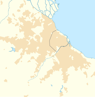
Located principally in the city centre or Cercado de Lima and Rímac areas, the Historic Centre of Lima is among the most important tourist destinations in Peru.

Jesús María District, Lima District in Lima, Peru

Jesús María is one of the most centrally located districts of Lima, Peru. It is a middle-class, high density district and it usually ranks in the top districts with the best quality of life in Lima with an HDI of 0.770 (2005), only behind the districts of San Isidro and Miraflores.

Pueblo Libre District in Lima, Peru

Pueblo Libre is a district of the Lima Province in Peru and one of the districts that comprise the city of Lima. Its name, which means Free Town or Free People, was granted by José de San Martín on April 10, 1822 as a recognition of the patriotism shown by its inhabitants during the Peruvian War of Independence. The district was created by law 9162 on November 5, 1940. The current mayor of Pueblo Libre is Jhonel Leguia and the district's postal code is 21. Pueblo Libre is a middle-class residential community and has the most parks in Lima, although it has several branches of banks, local private universities and major corporations. With a Human Development Index HDI of 0.7667 in 2007, a high level, the same that has increased in recent years. Educational coverage is 98% and service coverage reaches 99.7%.

San Isidro, Buenos Aires City in Buenos Aires, Argentina

San Isidro is a municipality in Greater Buenos Aires. It is located 27.9 km from the Autonomous City of Buenos Aires (CABA). It ranks as the province's most affluent neighborhood.

Jirón de la Unión pedestrian Peruvian street

The Jiron de la Union, or the Jiron of the Union, is a pedestrian street located in the Historic Centre of Lima, part of the capital of Peru. For many decades it was the most important boulevards of the city, often described as the most aristocratic, where many of the most affluent citizens of the city and most powerful men around the world would meet. Subsequently, with the deterioration of the centre of Lima, the Jiron de la Union lost its aristocratic character and became completely commercialized.

Archbishops Palace of Lima cultural heritage site in Peru

The Archbishop's Palace of Lima, the capital of Peru, is the residence of the Archbishop of Lima, and the administrative headquarters of the Roman Catholic Archdiocese of Lima. It is located on the Plaza Mayor of Lima, in the Historic Centre of Lima.

Plaza Mayor, Lima cultural heritage site in Peru

The Plaza Mayor or Plaza de Armas of Lima, is the birthplace of the city of Lima, as well as the core of the city. Located in the Historic Centre of Lima, it is surrounded by the Government Palace, Cathedral of Lima, Archbishop's Palace of Lima, the Municipal Palace, and the Palace of the Union.

Desamparados station cultural heritage site in Peru

The Desamparados station is a railway station in Lima, Peru. It is situated on the left margin of the Rímac River, next to the Government Palace. The station was named after the church of Nuestra Señora de los Desamparados. The project began in 1890 by the Peruvian Corporation and three years later the Lima–La Oroya route was inaugurated. The line became known as the Ferrocarril Central Andino

Gran Hotel Bolivar

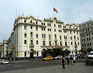
The Gran Hotel Bolívar, is a historic hotel located on Plaza San Martín in Lima, Peru. Designed by noted Peruvian architect Rafael Marquina, it was built in 1924 and was the first large, modern hotel built in Lima.

National Superior Autonomous School of Fine Arts, Lima cultural heritage site in Peru

Escuela Nacional Superior Autónoma de Bellas Artes del Perú (ENSABAP) is a fine arts school in Lima, Peru. It is located in Barrios Altos, a suburb of Lima District. It was founded in 1918, by President José Pardo y Barreda and Peruvian painter Daniel Hernández, who was its first director. It is located in a monumental building built in the early 1940s.

Protectorate of Peru protectorate created in 1821 in modern Peru after its declaration of independence

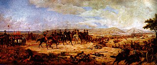
The Protectorate of Peru was a protectorate created in 1821 in modern Peru after its declaration of independence. It existed for a year and 17 days, under the rule of José de San Martín.

José de San Martín is the national hero of Argentina, Chile and Peru, and along with Simón Bolívar, the most important Libertador of the Spanish American Wars of Independence. For this reason, he is homaged and depicted in several cultural works of those countries, and even internationally.

Historic Centre of Trujillo Place in La Libertad, Peru

The Historic Centre of Trujillo is the main urban area and the most important center of development and unfolding in the Peruvian city of Trujillo located in La Libertad Region. The whole process of its original urban fabric is in elliptical shape surrounded by España Avenue that was built in the wake of the Wall of Trujillo. It houses the seat of city government and other important entities in the locality. In the center of this historic urban area is the Plaza de Armas of Trujillo that was the scene of the Spanish founded of the city in 1534 and the proclamation of the independence of Trujillo on December 29, 1820.

Palacio Municipal de Caracas national historical monument of Venezuela in Caracas

The Palacio Municipal de Caracas, or Consejo Municipal de Caracas, is the city hall of Caracas, Venezuela. It is located on the corner of Gradillas a Monjas opposite the Plaza Bolívar, occupying half of the plaza's southern section. The building dates from the seventeenth century but now bears the mark of Alejandro Chataing's Neoclassical additions in 1906. It was the focal point for the Constitutional Convention, and signing of the Declaration of Independence in the nineteenth century. The present building is the result of the work undertaken by the Venezuelan architect Alejandro Chataing in 1906. The west wing of the building, the Capilla de Santa Rosa de Lima, the chapel where Venezuela's independence was declared in 1811, has been fully restored and furnished with authentic period pieces. The ground floor houses the Museo Caracas, which contains works by Venezuela's most celebrated painters and many other historic artifacts. It was declared a National Historic Landmark on 16 February 1979.

Victorio Macho Spanish sculptor

Victorio Macho was a renowned 20th century Spanish sculptor. He is considered to be one of the greats of modern Spanish sculpture. His style was influenced by art deco. His home and workshop in Toledo was converted into a museum dedicated to his work, the Victorio Macho Museum, after his death. He has been featured on a postage stamp of Spain.

Plaza Bolívar (Valencia) Public square with monument

The Plaza Bolivar is a square in Valencia, Venezuela. It occupies a central site, and is used for public meetings. Its origin was in the colonial period, when the city was laid out on a grid plan.(see note) The square was renamed after Simón Bolívar in the 19th century. Some buildings in the vicinity, such as the Cathedral date from the colonial period, but the square is noted for a monumental column celebrating Venezuela´s independence. Inaugurated in 1889, the column commemorates Bolívar and the battle of Carabobo (1821).

References

National University of Engineering public Peruvian university

The National University of Engineering is a public engineering and science university located in the Rímac District of Lima, Peru.

Commons-logo.svg Media related to Plaza San Martín (Lima) at Wikimedia Commons

Coordinates: 12°03′05″S77°02′04″W / 12.0515°S 77.0345°W / -12.0515; -77.0345

Geographic coordinate system Coordinate system

A geographic coordinate system is a coordinate system that enables every location on Earth to be specified by a set of numbers, letters or symbols. The coordinates are often chosen such that one of the numbers represents a vertical position and two or three of the numbers represent a horizontal position; alternatively, a geographic position may be expressed in a combined three-dimensional Cartesian vector. A common choice of coordinates is latitude, longitude and elevation. To specify a location on a plane requires a map projection.