Museum of the Nation

Last updated
Museum of the Nation
Museum of the Nation, Lima, Peru.jpg
Location Lima, Peru
The museum entrance Museo de la Nacion entrance.JPG
The museum entrance
Pre-Columbian jug in the shape of a man Peruvian human jug 01.jpg
Pre-Columbian jug in the shape of a man

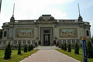
The Museum of the Nation(Museo de la Nación) is one of two major museums of Peruvian history in Lima, Peru. It is much larger than the other main museum in Lima, the Peruvian National Museum of Archaeology, Anthropology, and History.

The history of Peru spans 4 millennia, extending back through several stages of cultural development in the mountain region and the lakes. Peru was home to the Norte Chico civilization, the oldest civilization in the Americas and one of the six oldest in the world, and to the Inca Empire, the largest and most advanced state in Pre-Columbian America. It was conquered by the Spanish Empire in the 16th century, which established a Viceroyalty with jurisdiction over most of its South American domains. The nation declared independence from Spain in 1821, but consolidated only after the Battle of Ayacucho, three years later.

Lima Capital city in Peru

Lima is the capital and the largest city of Peru. It is located in the valleys of the Chillón, Rímac and Lurín rivers, in the central coastal part of the country, overlooking the Pacific Ocean. Together with the seaport of Callao, it forms a contiguous urban area known as the Lima Metropolitan Area. With a population of more than 9 million, Lima is the most populous metropolitan area of Peru and the third-largest city in the Americas, behind São Paulo and Mexico City.

Peru republic in South America

Peru, officially the Republic of Peru, is a country in western South America. It is bordered in the north by Ecuador and Colombia, in the east by Brazil, in the southeast by Bolivia, in the south by Chile, and in the west by the Pacific Ocean. Peru is a megadiverse country with habitats ranging from the arid plains of the Pacific coastal region in the west to the peaks of the Andes mountains vertically extending from the north to the southeast of the country to the tropical Amazon Basin rainforest in the east with the Amazon river.

Contents

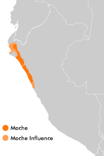
Normally, the Museum of the Nation houses thousands of artifacts spanning the entire span of human occupation in Peru, including an impressive collection of Moche, Nazca, and Wari ceramics. The museum also houses reproductions of many famous ancient Andean artifacts, most notably the Lanzón from Chavín de Huantar ; a recreation of the burial chamber of the Lord of Sipan (El Señor de Sipán); and the famous Revolt of the Objects Mural. However it is currently undergoing remodelling so for the most part only temporary exhibitions are available for the public to view.

One of the exhibits that remains open is on the 6th floor of the museum which houses the photographic exhibit Yuyanapaq. Para Recordar. This exhibit was created by the Truth and Reconciliation Commission to document the internal conflict in Peru that occurred from 1980-2000 involving the Shining Path.

Peru's Truth and Reconciliation Commission (TRC) was a truth and reconciliation commission established by President Alejandro Toledo to investigate the human rights abuses committed during the 1980s and 1990s. The TRC was a response to the violent internal conflict between 1980 and 2000 during the administration of Presidents Fernando Belaúnde (1980-1985), Alan García (1985–1990), and Alberto Fujimori (1990–2000). The commission's mandate was to provide a record of human rights and international humanitarian law violations committed in Peru between May 1980 and November 2000, as well as recommend mechanisms to promote and strengthen human rights. The TRC reported on the estimated 70 000 deaths, assassinations, torture, disappearances, displacement, employment of terrorist methods and other human rights violations executed by the State, Shining Path, and the Túpac Amaru Revolutionary Movement. The report concluded that there is both institutional and individual accountability, as well as identifying racial and cultural factors that became a catalyst for conflict.

Internal conflict in Peru insurgency waged by armed communist groups in Peru

The internal conflict in Peru is an ongoing armed conflict between the Government of Peru, the Communist Party of Peru, and the Túpac Amaru Revolutionary Movement. The conflict began on May 17, 1980. It is estimated that there have been nearly 70,000 deaths, making it the bloodiest war in Peruvian history, since the European colonization of the country.

Shining Path communist organization labeled as a terrorist group in Peru

The Communist Party of Peru – Shining Path, more commonly known as the Shining Path, is a communist revolutionary organization in Peru, espousing Marxism-Leninism-Maoism. When it first launched the internal conflict in Peru in 1980, its goal was to overthrow the state by guerrilla warfare and replace it with a "New Democracy". The Shining Path believed that by establishing a dictatorship of the proletariat, inducing a cultural revolution, and eventually sparking a world revolution, they could arrive at full communism. Their representatives stated that existing socialist countries were revisionist, and the Shining Path was the vanguard of the world communist movement. The Shining Path's ideology and tactics have been influential among other Maoist insurgent groups, notably the Communist Party of Nepal and other Revolutionary Internationalist Movement-affiliated organizations.

See also

Related Research Articles

Moche culture Moche civilisation

The Moche civilization flourished in northern Peru with its capital near present-day Moche, Trujillo, Peru from about 100 to 700 AD during the Regional Development Epoch. While this issue is the subject of some debate, many scholars contend that the Moche were not politically organized as a monolithic empire or state. Rather, they were likely a group of autonomous polities that shared a common culture, as seen in the rich iconography and monumental architecture that survives today.

Ica, Peru Place in Ica, Peru

The city of Ica is the capital of the Department of Ica in southern Peru. While the area was long inhabited by varying cultures of indigenous peoples, the Spanish conquistador Gerónimo Luis de Cabrera claimed its founding in 1563. As of the 2017 census, it had a population of over 282,407. The city suffered extensive damage and loss of life during the 2007 Peru earthquake.

Lambayeque, Peru Place in Lambayeque, Peru

Lambayeque is a city in the Lambayeque region of northern Peru. It is notable for its exceptional museums featuring artifacts from local prehistoric archaeological sites.

Barranco District District in Lima, Peru

Barranco is one of 43 districts in Lima, Peru. Its current mayor is Jose Rodriguez Cardenas.

Rímac District District in Lima, Peru

Rímac is a district in the Lima Province, Peru. It lies directly to the north of downtown Lima, to which it is connected by six bridges over the Rímac River. The district also borders the Independencia, San Martín de Porres, and San Juan de Lurigancho districts. Vestiges of Lima's colonial heyday remain today in an area of the Rímac district known as the Historic centre of Lima, which was declared a UNESCO World Heritage Site in 1988. Downtown Rímac District has, like its southern counterpart, its eastern and western sides divided by Jirón Trujillo, which connects to Lima District's Jirón de la Unión through the Puente de Piedra, the oldest bridge in the whole city. Rímac's East side features the Plaza de Acho, the most famous bullfighting arena in South America and one of the most well known in the world.

Huaca Rajada archaeological site in northern Peru

Huaca Rajada, also known as Sipán, is a Moche archaeological site in northern Peru in the Lambayeque Valley, that is famous for the tomb of Lord of Sipán, excavated by Walter Alva and his wife Susana Meneses beginning in 1987. The city of Sipán is dated from 50–700 AD, the same time as the Moche Period.

Pueblo Libre District in Lima, Peru

Pueblo Libre is a district of the Lima Province in Peru and one of the districts that comprise the city of Lima. Its name, which means Free Town or Free People, was granted by José de San Martín on April 10, 1822 as a recognition of the patriotism shown by its inhabitants during the Peruvian War of Independence. The district was created by law 9162 on November 5, 1940. The current mayor of Pueblo Libre is Jhonel Leguia and the district's postal code is 21. Pueblo Libre is a middle-class residential community and has the most parks in Lima, although it has several branches of banks, local private universities and major corporations. With a Human Development Index HDI of 0.7667 in 2007, a high level, the same that has increased in recent years. Educational coverage is 98% and service coverage reaches 99.7%.

National Museum of the Archaeology, Anthropology, and History of Peru, Lima museum in Lima, Peru

The Museo Nacional de Arqueología Antropología e Historia del Perú is the largest and oldest museum in Peru, located on Plaza Bolívar in the Pueblo Libre district of Lima. The museum houses more than 100,000 artifacts spanning the entire history of human occupation in what is now Peru. Highlights include the Raimondi Stele and the Tello Obelisk from Chavín de Huantar, and an impressive scale model of the Incan citadel, Machu Picchu.

Allen County Museum Childrens Museum, History Museum in Lima, Ohio United States

The Allen County Museum is located in the city of Lima, the county seat of Allen County, Ohio, United States. Occupying a half city block, the museum campus includes the main museum building, a log house, the MacDonell House, a Shay Locomotive display, the Children's Discovery Center, genealogy and local history library, railroad archives, and the Children's Garden. The museum is accredited by the American Alliance of Museums. According to recent reports of the American Alliance of Museums Accreditation Department, less than 800 museums, out of more than 11,000 in the United States, are accredited. Standards for accreditation apply across the board to both small and large institutions.

Lima Stock Exchange Stock exchange located in Lima, Peru

The Lima Stock Exchange is the stock exchange of Peru, located in the capital Lima. It has several indices. The S&P/BVL Peru General Index is a value-weighted index that tracks the performance of the largest and most frequently traded stocks on the Lima Exchange.

Lord of Sipán

The Lord of Sipán is the name given to the first of several Moche mummies found at Huaca Rajada, Sipán, Peru by archaeologist Walter Alva. The site was discovered in 1987.

Cementerio Presbítero Matías Maestro cemetery in Lima, Peru

The Cementerio Presbítero Matías Maestro is a cemetery in Lima, the capital city of Peru. It is also a museum, though attempts to make it a museum exclusively have failed. The architectural styles of the mausoleums found within are broad ranging. It houses the remains of several important political, military and literary figures. Most prominent of all the mausoleums is the Panteón de los Próceres where heroes of the War of the Pacific (1879–1884) are buried. The mausoleum's entrance reads "La Nación a sus Defensores".

Larco Museum

The Museo Larco is a privately owned museum of pre-Columbian art, located in the Pueblo Libre District of Lima, Peru. The museum is housed in an 18th-century vice-royal building. It showcases chronological galleries that provide a thorough overview of 5,000 years of Peruvian pre-Columbian history. It is well known for its gallery of pre-Columbian erotic pottery.

Tourism in Peru

Tourism in Peru makes up the nation's third largest industry, behind fishing and mining. Tourism is directed towards archaeological monuments, ecotourism in the Peruvian Amazon, cultural tourism in colonial cities, gastronomic tourism, adventure tourism, and beach tourism. According to a Peruvian government study, the satisfaction rate for tourists after visiting Peru is 94%. Tourism is the most rapidly growing industry in Peru, growing annually at a rate of 25% over the past five years. Tourism is growing in Peru faster than any other country in South America. Iperú is the Peruvian national tourist office.

Palacio de la Exposición

The Palacio de la Exposición is a building on Colon Avenue in downtown Lima, Peru. It was constructed in the 19th century with the Park of the Exposition to house the International Exposition of Lima in 1872. Since 1957, it has been home to the Lima Art Museum.

Casa de Correos y Telegrafos cultural heritage site in Peru

The Casa de Correos y Telegrafos is the central post office of the city of Lima, Peru. The building is located in the Historic center of Lima near the Plaza Mayor. The building was constructed in 1897 in a French architectural style. Additionally, the building houses the National Postal and Philatelic Museum. Besides displaying exhibits relating to postal service, the museum showcases exhibits relating to Limean history. The building is located along Piura street and its interior is lined with shops. Its facade contains a clock, and a bronze lion depicted with its snout open and devouring correspondence. The building occupies an area of 6,537 square meters.

Museum of Italian Art public museum in Lima, Peru

The Museum of Italian Art is a public museum in Lima, Peru, under the administration of the National Culture Institute. It's the only European arts museum in Peru.

Gold Museum of Peru and Arms of the World

The Gold Museum of Peru and Weapons of the World is a Peruvian museum, located in Lima.

Royal Tombs of Sipán Museum

The Royal Tombs of Sipán Museum is a museum in Lambayeque, Peru. It contains most of the important artifacts found at Huaca Rajada by archeologist Walter Alva in 1987, including the Lord of Sipán and his entourage. The museum was inaugurated in 2002. The museum was designed to resemble the ancient Moche tombs.

References

    Coordinates: 12°05′12″S77°00′07″W / 12.0868°S 77.0019°W / -12.0868; -77.0019

    Geographic coordinate system Coordinate system

    A geographic coordinate system is a coordinate system that enables every location on Earth to be specified by a set of numbers, letters or symbols. The coordinates are often chosen such that one of the numbers represents a vertical position and two or three of the numbers represent a horizontal position; alternatively, a geographic position may be expressed in a combined three-dimensional Cartesian vector. A common choice of coordinates is latitude, longitude and elevation. To specify a location on a plane requires a map projection.