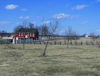
The Gettysburg Battlefield is the area of the July 1–3, 1863 military engagements of the Battle of Gettysburg within and around the borough of Gettysburg, Pennsylvania. Locations of military engagements extend from the 4-acre (1.6 ha) site of the first shot at Knoxlyn Ridge on the west of the borough, to East Cavalry Field on the east. A military engagement prior to the battle was conducted at the Gettysburg Railroad trestle over Rock Creek, which was burned on June 27.

U.S. Route 522 is a spur route of US 22 in the states of Virginia, West Virginia, Maryland, and Pennsylvania. The U.S. Highway travels in a north-south direction, and runs 308.59 miles (496.63 km) from US 60 near Powhatan, Virginia, to its northern terminus at US 11 and US 15 near Selinsgrove, Pennsylvania. US 522 serves many small cities and towns in the Piedmont, Blue Ridge Mountains, and northern Shenandoah Valley of Virginia. The highway serves the Virginia communities of Goochland, Mineral, Culpeper, the town of Washington, and Front Royal and the independent city of Winchester. US 522 then follows the Ridge-and-Valley Appalachians north and then east through the Eastern Panhandle of West Virginia, a 2-mile-wide (3.2 km) stretch of Western Maryland, and South Central Pennsylvania to its terminus in the Susquehanna Valley. The highway serves Berkeley Springs, West Virginia; Hancock, Maryland; and the Pennsylvania communities of McConnellsburg, Mount Union, Lewistown, and Middleburg.

The Peach Orchard is a Gettysburg Battlefield site at the southeast corner of the north-south Emmitsburg Road intersection with the Wheatfield Road. The orchard is demarcated on the east and south by Birney Avenue, which provides access to various memorials regarding the "momentous attacks and counterattacks in…the orchard on the afternoon of July 2, 1863."

The Gettysburg National Military Park protects and interprets the landscape of the Battle of Gettysburg, fought over three days between July 1 and July 3, 1863, during the American Civil War. Located in Gettysburg, Pennsylvania, the park is managed by the National Park Service.

Devil's Den is a boulder-strewn hill on the south end of Houck's Ridge at Gettysburg Battlefield, used by artillery and sharpshooters on the second day of the 1863 Battle of Gettysburg during the American Civil War. A tourist attraction since the memorial association era, several boulders are worn from foot traffic and the site includes numerous cannons, memorials, and walkways, including a bridge spanning two boulders.

Seminary Ridge is a dendritic ridge that served as an area of military engagements during the Battle of Gettysburg, the bloodiest battle of the American Civil War, which was fought between July 1 and July 3, 1863 in and around Gettysburg, Pennsylvania. Seminary Ridge also served as a military installation during World War II.

Pennsylvania Route 34 is a 62-mile-long (100 km) state route located in southern Pennsylvania. The southern terminus of the route is at U.S. Route 15 Business in Gettysburg. The northern terminus is at US 11/US 15 south of Liverpool. PA 34 heads north from Gettysburg through farmland in northern Adams County, passing through Biglerville. The route crosses South Mountain into Cumberland County and reaches Mount Holly Springs, where it intersects PA 94. PA 34 heads north into the agricultural Cumberland Valley and heads north to Carlisle, where it has an interchange with Interstate 81 (I-81) in the southern part of town and intersects US 11/PA 74/PA 641 in the downtown area. The route continues north through more rural land and crosses Blue Mountain into Perry County, where it continues through the Ridge-and-Valley Appalachians, winding north to New Bloomfield. From here, PA 34 continues northeast to Newport, where it crosses the Juniata River and reaches an interchange with US 22/US 322, before heading to its terminus at US 11/US 15 near the Susquehanna River.

Big Round Top is a boulder-strewn hill notable as the topographic high point of the Gettysburg Battlefield and for 1863 American Civil War engagements for which Medals of Honor were awarded. In addition to battle monuments, a historic reconstruction era structure on the uninhabited hill is the Big Round Top Observation Tower Foundation Ruin.

Rock Creek is an 18.9-mile-long (30.4 km) tributary of the Monocacy River in south-central Pennsylvania and serves as the border between Cumberland and Mount Joy townships. Rock Creek was used by the Underground Railroad and flows near several Gettysburg Battlefield sites, including Culp's Hill, the Benner Hill artillery location, and Barlow Knoll.

Pennsylvania Route 116 is an east–west route located Adams and York counties in southern Pennsylvania. The route begins at PA 16 in Carroll Valley in Adams County, heading northeast through rural areas and passing through Fairfield. PA 116 passes through the historic Civil War town of Gettysburg, where the Battle of Gettysburg was held. In Gettysburg, the route intersects U.S. Route 15 Business and US 30 in the town center. From Gettysburg, PA 116 heads southeast and comes to an interchange with the US 15 freeway in Straban Township as it heads into farmland and curves east. The route passes through Bonneauville and McSherrystown before it crosses into York County and heads into Hanover. Here, the route forms a concurrency with PA 194 and crosses PA 94 in the downtown area. PA 116 intersects PA 216 before it leaves Hanover and heads northeast through rural land. The route has an intersection with PA 516 near Spring Grove before it ends at US 30 in West Manchester Township, west of York.

Pennsylvania Route 97 is one of two Pennsylvania state highways that carries the PA 97 designation; the other PA 97 is in Erie County. This southern PA 97, known for most of its length as Baltimore Pike, runs 9.363 miles (15.068 km) from the Maryland state line near Littlestown, where the highway continues as Maryland Route 97, northwest to U.S. Route 15 near Gettysburg. PA 97 connects Gettysburg and Littlestown in southeastern Adams County. The highway also links those communities with Westminster and Baltimore. From PA 97's northern end, Baltimore Pike continues toward Gettysburg as State Route 2035 through the Gettysburg Battlefield Historic District, where it provides access to the Gettysburg Museum and Visitor Center.

U.S. Route 15 (US 15) is a part of the United States Numbered Highway System that runs from Walterboro, South Carolina, north to Painted Post, New York. In Maryland, the highway runs 37.85 miles (60.91 km) from the Virginia state line at the Potomac River in Point of Rocks north to the Pennsylvania state line near Emmitsburg. Known for most of its length as Catoctin Mountain Highway, US 15 is the primary north–south highway of Frederick County. The highway connects the county seat of Frederick with Point of Rocks, Leesburg, Virginia, and Charles Town, West Virginia, to the south and with Thurmont, Emmitsburg, and Gettysburg, Pennsylvania, to the north. US 15 is a four-lane divided highway throughout the state except for the portion between the Point of Rocks Bridge and the highway's junction with US 340 near Jefferson. The highway is a freeway along its concurrency with US 340 and through Frederick, where the highway meets US 40 and Interstate 70 (I-70). US 15 has a business route through Emmitsburg.

Pennsylvania Route 134 (PA 134), also called Taneytown Road, is a north–south, two-lane state highway in Adams County, Pennsylvania. It runs from the Maryland border at the Mason–Dixon line in Mount Joy Township north to U.S. Route 15 Business in Gettysburg. PA 134 runs through farmland between the Maryland border and an interchange with the US 15 freeway. North of here, the route passes through Round Top and serves Gettysburg National Military Park before reaching its northern terminus. Taneytown Road was created in 1800 to connect Gettysburg with Taneytown, Maryland. The road was used during the 1863 Battle of Gettysburg for the procession to the cemetery consecration at which the Gettysburg Address was delivered. PA 134 was designated to its current alignment in 1928, with the section north of Round Top paved. The southern portion of the route was paved in the 1930s.

The Gettysburg Battlefield Historic District is a district of contributing properties and over 1000 historic contributing structures and 315 historic buildings, located in Adams County, Pennsylvania. The district was added to the National Register of Historic Places on March 19, 1975. Most of the contributing elements of the Gettysburg Battlefield are on the protected federal property within the smaller Gettysburg National Military Park.

Round Top is a populated place in Adams County in the U.S. state of Pennsylvania, near Little Round Top. It is notable for two Battle of Gettysburg hospitals, the 1884 Round Top Station, and several battlefield commemorative era attractions such as Round Top Park and the Round Top Museum. The unincorporated community lies on an elevated area of the north-south Taneytown Road with three intersections: at Blacksmith Shop Road to the northeast, Wheatfield Road, and Sachs Road.

Barlow is a populated place between the Gettysburg Battlefield and the Mason–Dixon line in Adams County, Pennsylvania, United States, situated at the intersection of Rock Creek and Pennsylvania Route 134. North of the creek on the road summit is the principal facility of the rural community: the 1939 community hall at the Barlow Volunteer Fire Company fire station. The hall is a Cumberland Township polling place and was used by Mamie and Dwight D. Eisenhower after purchasing their nearby farm. Horner's Mill was the site of an 1861 Union Civil War encampment, and the covered bridge was used by the II Corps and General George G. Meade en route to the 1863 Battle of Gettysburg.
Emmor Cope (1834-1927) was an American Civil War officer of the Union Army noted for the "Map of the Battlefield of Gettysburg from the original survey made August to October, 1863", which he researched by horseback as a sergeant after being ordered back to Gettysburg by Maj. Gen. George G. Meade. Cope is also noted for commemorative era battlefield administration and designs, including the layout of the 1913 Gettysburg reunion. Cope had enlisted as a Private of Company A,, temporarily detached to Battery C, 5th U.S. Artillery, and mustered out as a V Corps aide-de-camp of Maj Gen Gouverneur K. Warren.

The Wheatfield Road is a Gettysburg Battlefield crossroad from the Peach Orchard east-southeastward along the north side of The Wheatfield, north of the Valley of Death, and over the north foot of Little Round Top. In addition to modern tourist use, the road is notable for Battle of Gettysburg use and postbellum trolley use associated with the 1892-1896 US v. Gettysburg Electric Ry. case of the US Supreme Court.

Stevens Run is a 2.2-mile-long (3.5 km) tributary of Rock Creek in Pennsylvania in the United States.

McPherson Ridge is a landform used for military engagements during the 1863 Battle of Gettysburg, when the I Corps of the Union Army had a headquarters on the ridge and was defeated by the Confederate division of Major General Henry Heth. The ridge has terrain above ~530 ft (160 m) and is almost entirely a federally protected area except for township portions at the southern end and along Pennsylvania Route 116, including a PennDOT facility. The northern end is a slight topographic saddle point on the west edge of Oak Ridge, and summit areas above 560 ft (170 m) include 4 on/near the Lincoln Highway, a broader summit south of the Fairfield Road, and the larger plateau at the northern saddle.


