
Lake-effect snow is produced during cooler atmospheric conditions when a cold air mass moves across long expanses of warmer lake water. The lower layer of air, heated by the lake water, picks up water vapor from the lake and rises through colder air. The vapor then freezes and is deposited on the leeward (downwind) shores.

Milwaukee is the most populous city in the U.S. state of Wisconsin and the seat of Milwaukee County. With a population of 577,222 at the 2020 census, Milwaukee is the 31st-most populous city in the United States and the fifth-most populous city in the Midwest. It is the central city of the Milwaukee metropolitan area, the 40th-most populous metro area in the U.S. with 1.57 million residents.

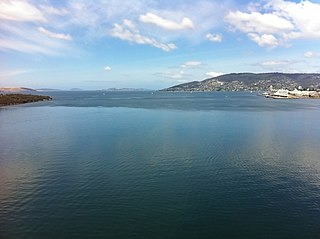
Greilickville is an unincorporated community and census-designated place (CDP) in Leelanau County in the U.S. state of Michigan. At the 2020 census, the population was 1,634, up from 1,530 at the 2010 census. The community is located within Elmwood Charter Township, and is located in the extreme southeast of the Leelanau Peninsula.
A sea breeze or onshore breeze is any wind that blows from a large body of water toward or onto a landmass. By contrast, a land breeze or offshore breeze is any wind that blows from a landmass toward or onto a large body of water. The term offshore wind may refer to any wind over open water. Sea breezes and land breezes are both important factors in coastal regions' prevailing winds.
On Saturday, November 11, 1911, a cold snap, known as the Great Blue Norther of 11/11/11, affected the Central United States. Many cities broke record highs, going into the 70s and 80s early that afternoon. By nightfall, cities were dealing with temperatures in the teens and single-digits on the Fahrenheit scale. This is the only day in many midwest cities' weather bureau jurisdictions where the record highs and lows were broken for the same day. Some cities experienced tornadoes on Saturday and a blizzard on Sunday. A blizzard even occurred within one hour after an F4 tornado hit Rock County, Wisconsin.

The climate of Chicago is classified as hot-summer humid continental with hot humid summers and cold, occasionally snowy winters. All four seasons are distinctly represented: Winters are cold and often see snow with below 0 Celsius temperatures and windchills, while summers are warm and humid with temperatures being hotter inland, spring and fall bring bouts of both cool and warm weather and fairly sunny skies. Annual precipitation in Chicago is moderate and relatively evenly distributed, the driest months being January and February and the wettest July and August. Chicago's weather is influenced during all four seasons by the nearby presence of Lake Michigan.
The climate of Salt Lake City, Utah features cold and snowy winters, hot and dry summers, and modest to light seasonal rainfall. Lying in the Salt Lake Valley, the city is surrounded by mountains and the Great Salt Lake. Under the Köppen climate classification, Salt Lake City has either a Mediterranean climate (Csa) or dry-summer continental climate (Dsa) depending on which variant of the system is used, though it borders on a cold semi-arid climate (BSk) due to the city's relatively low precipitation.

A rainband is a cloud and precipitation structure associated with an area of rainfall which is significantly elongated. Rainbands in tropical cyclones can be either stratiform or convective and are curved in shape. They consist of showers and thunderstorms, and along with the eyewall and the eye, they make up a tropical cyclone. The extent of rainbands around a tropical cyclone can help determine the cyclone's intensity.
The Great Blizzard of 1978 was a historic winter storm that struck the Ohio Valley and Great Lakes regions of the United States as well as Southern Ontario in Canada from Wednesday, January 25 through Friday, January 27, 1978. It is often cited as one of the most severe blizzards in US history. The third lowest non-tropical atmospheric pressure ever recorded in the mainland United States occurred as the storm passed over Mount Clemens, Michigan, where barometer readings fell to 956.0 mb (28.23 inHg) on January 26.
Milwaukee has a humid continental climate, with four distinct seasons and wide variations in temperature and precipitation in short periods of time. The city's climate is also strongly influenced by nearby Lake Michigan, which creates two varying climates within the Milwaukee area. The urban heat island effect also plays a role in the city's climate, insulating it from winter cold, but keeping it cooler in spring and summer.
A cold wave is a weather phenomenon that is distinguished by a cooling of the air. Specifically, as used by the U.S. National Weather Service, a cold wave is a rapid fall in temperature within a 24-hour period requiring substantially increased protection to agriculture, industry, commerce, and social activities. The precise criteria for a cold wave are the rate at which the temperature falls, and the minimum to which it falls. This minimum temperature is dependent on the geographical region and time of year.
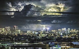
The climate of Sydney, Australia is humid subtropical, shifting from mild and cool in winter to warm and occasionally hot in the summer, with no extreme seasonal differences as the weather is moderated by proximity to the ocean, although more contrasting temperatures are recorded in the inland western suburbs. Despite the fact that there is no distinct dry or wet season, rainfall peaks during summer and autumn months, and is at its lowest just around the middle of the year, though precipitation can be erratic throughout the year. Precipitation varies across the region, with areas adjacent to the coast being the wettest. According to the Bureau of Meteorology, Sydney falls in the temperate climate zone which has warm to hot summers and no dry season. Sydney's plant hardiness zone ranges from zone 11a to 9b throughout the metropolitan area. Under the Holdridge Life Zones classification, eastern Sydney falls in the Subtropical Moist Forest zone and the western suburbs in the Subtropical Dry Forest zone.
Delhi features a monsoon influenced humid subtropical climate bordering a hot semi-arid climate, with high variation between summer and winter temperatures and precipitation. Delhi's version of a humid subtropical climate is markedly different from many other humid subtropical cities such as São Paulo, Houston, and Brisbane in that the city features dust storms and wildfire haze due to its semi-arid climate.

The climate of the United States varies due to changes in latitude, and a range of geographic features, including mountains and deserts. Generally, on the mainland, the climate of the U.S. becomes warmer the farther south one travels, and drier the farther west, until one reaches the West Coast.
Global weather activity of 2007 profiles the major worldwide weather events, including blizzards, ice storms, tornadoes, tropical cyclones, and other weather events, from January 1, 2007, to December 31, 2007. Winter storms are events in which the dominant varieties of precipitation are formed during cold temperatures; they include snow or sleet, or a rainstorm where ground temperatures are cold enough to allow ice, including freezing rain, to form. Thehy may be marked by strong wind, thunder, lightning thunderstorms, heavy precipitation, including ice storm, wind transporting some substance through the atmosphere, including dust storms, snowstorms, and hail storms. Other major non winter events such as large dust storms, hurricanes, cyclones, tornados, gales, flooding, and rainstorms are also caused by such phenomena.

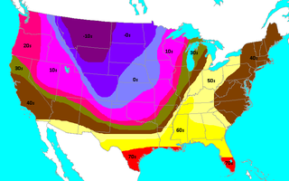
The January–March 2014 North American cold wave was an extreme weather event that extended through the late winter months of the 2013–2014 winter season, and was also part of an unusually cold winter affecting parts of Canada and parts of the north-central and northeastern United States. The event occurred in early 2014 and was caused by a southward shift of the North Polar Vortex. Record-low temperatures also extended well into March.

The 2019–20 North American winter was unusually warm for many parts of the United States; in many areas, neutral ENSO conditions controlled the weather patterns, resulting in strong El Niño like conditions and the sixth-warmest winter on record, and many areas in the Northeastern United States saw one of the least snowy winters in years. In fact, Baltimore and Islip saw no snow in February for the first time. Some notable events still occurred, such as a powerful blizzard that impacted the Western United States in late November, a series of cold shots in January and February, a snowstorm within the Texas Panhandle and a late-season blizzard in the High Plains.

The climate of Door County, Wisconsin is tempered by Green Bay and Lake Michigan. There are fewer extremely cold days and fewer hot days than in areas of Wisconsin directly to the west. Lake waters delay the coming of spring as well as extend mild temperatures in the fall. Annual precipitation is slightly lower than elsewhere in northern Wisconsin. The county features a humid continental climate with warm summers and cold snowy winters.
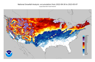
The 2022–23 North American winter was an unusually warm winter for the east and an unusually cold winter for the west in North America, as it occurred across the continent from late 2022 to early 2023. The winter season in North America began at the winter solstice, which occurred on December 21, 2022, and it ended at the March equinox, which occurred on March 20, 2023. The first day of meteorological winter began on December 1 and unofficially ended on February 28; winter storms may still occur outside of these limits.
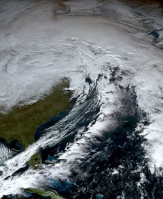
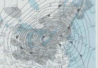
From December 21 to 26, 2022, an extratropical cyclone created crippling winter storm conditions, including blizzards, high winds, snowfall, and record cold temperatures across the majority of the United States and parts of Canada. Areas which experienced blizzard conditions included parts of Minnesota, Iowa, Wisconsin, Michigan, Ohio, Pennsylvania, New York and Ontario, with the Buffalo area of New York and the Fort Erie and Kingston areas of Ontario experiencing almost two full days of blizzard/zero-visibility conditions starting from December 23. The cold wave affected all U.S. states from Colorado to the Eastern Seaboard, with effects felt as far south as Miami, Florida. On December 24, 110 million people across 36 states were subject to wind chill alerts.

