Podzemelj

Last updated
Podzemelj
Village
Podzemelj1.JPG
Slovenia location map.svg
Red pog.svg
Podzemelj
Location in Slovenia
Coordinates: 45°36′31.32″N15°16′24.41″E / 45.6087000°N 15.2734472°E / 45.6087000; 15.2734472 Coordinates: 45°36′31.32″N15°16′24.41″E / 45.6087000°N 15.2734472°E / 45.6087000; 15.2734472
Country Flag of Slovenia.svg Slovenia
Traditional region White Carniola
Statistical region Southeast Slovenia
Municipality Metlika
Area
  Total1.98 km2 (0.76 sq mi)
Elevation
155.3 m (509.5 ft)
Population
(2002)
  Total150
[1]

Podzemelj (pronounced  [pɔdˈzeːməl] ; German : Podsemel [2] ) is a village on the left bank of the Kolpa River in the Municipality of Metlika in the White Carniola area of southeastern Slovenia, next to the border with Croatia. The area is part of the traditional region of Lower Carniola and is now included in the Southeast Slovenia Statistical Region. [3]

German language West Germanic language

German is a West Germanic language that is mainly spoken in Central Europe. It is the most widely spoken and official or co-official language in Germany, Austria, Switzerland, South Tyrol (Italy), the German-speaking Community of Belgium, and Liechtenstein. It is also one of the three official languages of Luxembourg and a co-official language in the Opole Voivodeship in Poland. The languages which are most similar to German are the other members of the West Germanic language branch: Afrikaans, Dutch, English, the Frisian languages, Low German/Low Saxon, Luxembourgish, and Yiddish. There are also strong similarities in vocabulary with Danish, Norwegian and Swedish, although those belong to the North Germanic group. German is the second most widely spoken Germanic language, after English.

Village Small clustered human settlement smaller than a town

A village is a clustered human settlement or community, larger than a hamlet but smaller than a town, with a population ranging from a few hundred to a few thousand. Though villages are often located in rural areas, the term urban village is also applied to certain urban neighborhoods. Villages are normally permanent, with fixed dwellings; however, transient villages can occur. Further, the dwellings of a village are fairly close to one another, not scattered broadly over the landscape, as a dispersed settlement.

Municipality An administrative division having corporate status and usually some powers of self-government or jurisdiction

A municipality is usually a single administrative division having corporate status and powers of self-government or jurisdiction as granted by national and regional laws to which it is subordinate. It is to be distinguished (usually) from the county, which may encompass rural territory or numerous small communities such as towns, villages and hamlets.

Contents

Name

Podzemelj was mentioned in medieval written sources only with reference to the village church, as (ecclesia) sancti Martini 'Saint Martin's Church' in 1279 and as ecclesia sancti Martini prope Culpam 'Saint Martin's Church near the Kolpa River' in 1337. The name is derived from a combination of the preposition *podъ 'under, below' + *zemľa 'earth', referring to a ditch built for defense purposes (this is also the origin of neighboring Zemelj). The name therefore means '(settlement) below the trench'. [4]

Kupa river

The Kupa or Kolpa river, a right tributary of the Sava, forms a natural border between north-west Croatia and southeast Slovenia. It is 297 kilometres long, with its border part having a length of 118 km (73 mi) and the rest located in Croatia.

Zemelj in White Carniola, Slovenia

Zemelj is a small settlement on the left bank of the Kolpa River in the Municipality of Metlika in the White Carniola area of southeastern Slovenia. The area is part of the traditional region of Lower Carniola and is now included in the Southeast Slovenia Statistical Region.

History

A fortified prehistoric settlement, one of the largest in White Carniola, was located on Kučar Hill (222 m) above Podzemelj. It existed from the first millennium BC at least to the Roman era, and Roman inscriptions have been found at the site dedicated to the deity Silvanus. Excavations indicate that settlement may have lasted at the site until the Middle Ages. The inhabitants of the hill settlement buried their dead in mound graves at Podzemelj and elsewhere; the mound burial site at Podzemelj consists of approximately 30 burial mounds. Almost all of them were excavated before the First World War and the finds were transferred to the archaeological museum in Vienna. [5]

Silvanus (mythology) deity

Silvanus was a Roman tutelary deity of woods and fields. As protector of the forest, he especially presided over plantations and delighted in trees growing wild. He is also described as a god watching over the fields and husbandmen, protecting in particular the boundaries of fields. The similarly named Etruscan deity Selvans may be a borrowing of Silvanus, or not even related in origin.

In 1523 the village consisted of eight farms. A school was first established in Podzemelj in 1857. During the Second World War, an officer training school operated in the village in August 1944. From October 1944 to May 1945, the British military mission operated a radio transmitter in Podzemelj for aircraft using the field at Otok. [5]

Otok, Metlika Place in White Carniola, Slovenia

Otok is a village on the left bank of the Kolpa River in the Municipality of Metlika in the White Carniola area of southeastern Slovenia, right on the border with Croatia. The area is part of the traditional region of Lower Carniola and is now included in the Southeast Slovenia Statistical Region.

Archaeology

In 2018, archaeologists unearthed fifteen graves at the Pezdirčeva Njiva site. The graves contained pottery and iron grave goods and dates back to the 4th and 3rd century B.C. In one of the graves they also found a bronze belt with a gold coin. The coin is a Celtic imitation of the Alexander the Great stater, depicting Nike and Athena, and dates back to the first half of the 3rd century B.C. According to the archaeologists this was a very significant discovery. Such coins are very rare. [6]

Celts Ethnolinguistic group

The Celts are an Indo-European ethnolinguistic group of Europe identified by their use of Celtic languages and cultural similarities. The history of pre-Celtic Europe and the exact relationship between ethnic, linguistic and cultural factors in the Celtic world remains uncertain and controversial. The exact geographic spread of the ancient Celts is disputed; in particular, the ways in which the Iron Age inhabitants of Great Britain and Ireland should be regarded as Celts have become a subject of controversy. According to one theory, the common root of the Celtic languages, the Proto-Celtic language, arose in the Late Bronze Age Urnfield culture of Central Europe, which flourished from around 1200 BC.

Alexander the Great King of Macedon

Alexander III of Macedon, commonly known as Alexander the Great, was a king (basileus) of the ancient Greek kingdom of Macedon and a member of the Argead dynasty. He was born in Pella in 356 BC and succeeded his father Philip II to the throne at the age of 20. He spent most of his ruling years on an unprecedented military campaign through Asia and northeast Africa, and by the age of thirty he had created one of the largest empires of the ancient world, stretching from Greece to northwestern India. He was undefeated in battle and is widely considered one of history's most successful military commanders.

Stater Ancient coin in Greece

The stater was an ancient coin used in various regions of Greece. The term is also used for similar coins, imitating Greek staters, minted elsewhere in ancient Europe.

Church

The local parish church is dedicated to Saint Martin and belongs to the Roman Catholic Diocese of Novo Mesto. It was first mentioned in written documents dating to 1279 and was extensively rebuilt in the Baroque style in the 18th century. [7] The altar furnishings are Baroque and the main altar painting was created in 1892 by Franc Blaznik. The sculptures on the side altars are of Tyrolean origin, the Stations of the Cross are the work of Joseph von Fürich, and the chancel arch was painted by Simon Ogrin Jr. The church was made the seat of a parish before 1338. [5]

Parish church church which acts as the religious centre of a parish

A parish church in Christianity is the church which acts as the religious centre of a parish. In many parts of the world, especially in rural areas, the parish church may play a significant role in community activities, often allowing its premises to be used for non-religious community events. The church building reflects this status, and there is considerable variety in the size and style of parish churches. Many villages in Europe have churches that date back to the Middle Ages, but all periods of architecture are represented.

Martin of Tours Christian saint

Saint Martin of Tours was the third bishop of Tours. He has become one of the most familiar and recognizable Christian saints in Western tradition.

Roman Catholic Diocese of Novo Mesto diocese of the Catholic Church

The Roman Catholic Diocese of Novo Mesto is a diocese located in the city of Novo Mesto in the Ecclesiastical province of Ljubljana in Slovenia.

Related Research Articles

Komenda Place in Upper Carniola, Slovenia

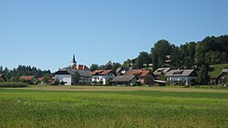
Komenda is a village in the Upper Carniola region of Slovenia. It is the seat of the Municipality of Komenda. It includes the formerly independent settlement of Kaplja Vas.

Metlika Town and Municipality in Slovenia

Metlika is a town and municipality in the southeastern Slovenia. It lies on the left bank of the Kolpa River on the border with Croatia. The municipality is at the heart of the area of White Carniola, the southeastern part of the traditional region of Lower Carniola. It is now included in the Southeast Slovenia Statistical Region.

Britof Place in Upper Carniola, Slovenia

Britof is a settlement just northeast of the town of Kranj in the Upper Carniola region of Slovenia.

Setnica, Dobrova–Polhov Gradec Place in Upper Carniola, Slovenia

Setnica is a settlement that is divided between the municipalities of Dobrova–Polhov Gradec and Medvode in the Upper Carniola region of Slovenia. Setnica is known as Snica in the local dialect. In the 19th century it was known as Setnitza in German. The settlement includes the hamlets of Ravnek to the south, Mežnar below Saint Ursula's Church, and Kobilca in the Maček Gorge.

Bojanja Vas Place in White Carniola, Slovenia

Bojanja Vas is a village in the Municipality of Metlika in the White Carniola area of southeastern Slovenia, next to the border with Croatia. The entire area is part of the traditional region of Lower Carniola and is now included in the Southeast Slovenia Statistical Region.

Boršt, Metlika Place in White Carniola, Slovenia

Boršt is a small settlement on the left bank of the Kolpa River in the Municipality of Metlika in the White Carniola area of southeastern Slovenia. The entire area is part of the traditional region of Lower Carniola and is now included in the Southeast Slovenia Statistical Region.

Gornji Suhor pri Metliki in White Carniola, Slovenia

Gornji Suhor pri Metliki is a settlement in the Municipality of Metlika in the White Carniola area of southeastern Slovenia, right on the border with Croatia. The entire area is part of the traditional region of Lower Carniola and is now included in the Southeast Slovenia Statistical Region.

Krasinec Place in White Carniola, Slovenia

Krasinec is a settlement on the left bank of the Kolpa River in the Municipality of Metlika in the White Carniola area of southeastern Slovenia, right on the border with Croatia. The area is part of the traditional region of Lower Carniola and is now included in the Southeast Slovenia Statistical Region.

Krašnji Vrh in White Carniola, Slovenia

Krašnji Vrh is a small village in the Municipality of Metlika in the White Carniola area of southeastern Slovenia, right on the border with Croatia. The area is part of the traditional region of Lower Carniola and is now included in the Southeast Slovenia Statistical Region.

Adlešiči Place in White Carniola, Slovenia

Adlešiči is a settlement on the left bank of the Kolpa River in the Municipality of Črnomelj in the White Carniola area of southeastern Slovenia. The area is part of the traditional region of Lower Carniola and is now included in the Southeast Slovenia Statistical Region. It also encompasses a hamlet to the east near the bank of the Kolpa River called Nabrežci, also known as Nabreško Selo.

Marindol in White Carniola, Slovenia

Marindol is a settlement on the terrace above the left bank of the Kolpa River in the Municipality of Črnomelj in the White Carniola area of southeastern Slovenia. The area is part of the traditional region of Lower Carniola and is now included in the Southeast Slovenia Statistical Region.

Purga, Slovenia in White Carniola, Slovenia

Purga is a small settlement above the left bank of the Kolpa River north of Adlešiči in the Municipality of Črnomelj in the White Carniola area of southeastern Slovenia. The area is part of the traditional region of Lower Carniola and is now included in the Southeast Slovenia Statistical Region.

Zilje in White Carniola, Slovenia

Zilje is a settlement above the left bank of the Kolpa River in the Municipality of Črnomelj in the White Carniola area of southeastern Slovenia. The area is part of the traditional region of Lower Carniola and is now included in the Southeast Slovenia Statistical Region.

Zapuže pri Ribnici Place in Lower Carniola, Slovenia

Zapuže pri Ribnici is a village in the hills north of Ribnica in southern Slovenia. The area is part of the traditional region of Lower Carniola and is now included in the Southeast Slovenia Statistical Region.

Veliko Trebeljevo Place in Lower Carniola, Slovenia

Veliko Trebeljevo is a settlement in the hills east of the capital Ljubljana in central Slovenia. It belongs to the City Municipality of Ljubljana. It was part of the traditional region of Lower Carniola and is now included with the rest of the municipality in the Central Slovenia Statistical Region.

Polšnik Place in Lower Carniola, Slovenia

Polšnik is a settlement in the Municipality of Litija in central Slovenia. Traditionally the area was part of Lower Carniola and is now included with the rest of the municipality in the Central Sava Statistical Region. Together with the two parts of the main settlement it also includes the hamlets of Na Puši, Seruč, Koprivnik, Slop, Glinjek, Velika Njiva, and Sušje.

Kolovrat, Zagorje ob Savi Place in Upper Carniola, Slovenia

Kolovrat is a settlement in the Municipality of Zagorje ob Savi in central Slovenia. The area is part of the traditional region of Upper Carniola. It is now included with the rest of the municipality in the Central Sava Statistical Region. The settlement includes the hamlets of Kal, Plavišnik, Prevalje, Spodnje Vrtače, Senčna Vas, and Strma Njiva.

Dobovec, Trbovlje Place in Lower Carniola, Slovenia

Dobovec is a settlement in the Municipality of Trbovlje in central Slovenia. It lies in the hills above the right bank of the Sava River. Traditionally the area was part of the Lower Carniola region. It is now included with the rest of the municipality in the Central Sava Statistical Region.

Veliko Mlačevo Place in Lower Carniola, Slovenia

Veliko Mlačevo is a village in the Municipality of Grosuplje in central Slovenia. It lies just southeast of Grosuplje itself in the historical region of Lower Carniola. The municipality is now included in the Central Slovenia Statistical Region. The settlement includes the hamlet of Boštanj south of the main settlement.

Šmartno ob Savi Place in Upper Carniola, Slovenia

Šmartno ob Savi is a formerly independent settlement in the northeast part of the capital Ljubljana in central Slovenia. It was part of the traditional region of Upper Carniola and is now included with the rest of the municipality in the Central Slovenia Statistical Region.

References

  1. Statistical Office of the Republic of Slovenia
  2. Leksikon občin kraljestev in dežel zastopanih v dravnem zboru, vol. 6: Kranjsko. 1906. Vienna: C. Kr. Dvorna in Državna Tiskarna, p. 12.
  3. Metlika municipal site
  4. Snoj, Marko. 2009. Etimološki slovar slovenskih zemljepisnih imen. Ljubljana: Modrijan and Založba ZRC, pp. 479–480.
  5. 1 2 3 Savnik, Roman, ed. 1971. Krajevni leksikon Slovenije, vol. 2. Ljubljana: Državna založba Slovenije, p. 457.
  6. A significant find at Pezdirčeva Njiva: A gold coin from the 3rd century B. C.
  7. Slovenian Ministry of Culture register of national heritage reference number ešd 2121