Gornji Suhor pri Metliki

Last updated
Gornji Suhor pri Metliki
Slovenia location map.svg
Red pog.svg
Gornji Suhor pri Metliki
Location in Slovenia
Coordinates: 45°41′34.56″N15°16′22.24″E / 45.6929333°N 15.2728444°E / 45.6929333; 15.2728444 Coordinates: 45°41′34.56″N15°16′22.24″E / 45.6929333°N 15.2728444°E / 45.6929333; 15.2728444
Country Flag of Slovenia.svg Slovenia
Traditional region White Carniola
Statistical region Southeast Slovenia
Municipality Metlika
Area
  Total 1.37 km2 (0.53 sq mi)
Elevation 375.6 m (1,232.3 ft)
Population (2002)
  Total 90
[1]

Gornji Suhor pri Metliki (pronounced  [ˈɡoːɾnji ˈsuːxɔɾ pɾi mɛˈtliːki] ; German : Obersuchor bei Möttling [2] [3] ) is a settlement in the Municipality of Metlika in the White Carniola area of southeastern Slovenia, right on the border with Croatia. The entire area is part of the traditional region of Lower Carniola and is now included in the Southeast Slovenia Statistical Region. [4]

German language West Germanic language

German is a West Germanic language that is mainly spoken in Central Europe. It is the most widely spoken and official or co-official language in Germany, Austria, Switzerland, South Tyrol (Italy), the German-speaking Community of Belgium, and Liechtenstein. It is also one of the three official languages of Luxembourg and a co-official language in the Opole Voivodeship in Poland. The languages which are most similar to German are the other members of the West Germanic language branch: Afrikaans, Dutch, English, the Frisian languages, Low German/Low Saxon, Luxembourgish, and Yiddish. There are also strong similarities in vocabulary with Danish, Norwegian and Swedish, although those belong to the North Germanic group. German is the second most widely spoken Germanic language, after English.

Municipality An administrative division having corporate status and usually some powers of self-government or jurisdiction

A municipality is usually a single administrative division having corporate status and powers of self-government or jurisdiction as granted by national and regional laws to which it is subordinate. It is to be distinguished (usually) from the county, which may encompass rural territory or numerous small communities such as towns, villages and hamlets.

Metlika Town and Municipality in Slovenia

Metlika is a town and municipality in the southeastern Slovenia. It lies on the left bank of the Kolpa River on the border with Croatia. The municipality is at the heart of the area of White Carniola, the southeastern part of the traditional region of Lower Carniola. It is now included in the Southeast Slovenia Statistical Region.

Contents

Name

The name of the settlement was changed from Gornji Suhor to Gornji Suhor pri Metliki in 1953. [5] The name literally means 'upper Suhor near Metlike', distinguishing the settlement from neighboring Dolnji Suhor pri Metliki (literally, 'lower Suhor near Metlike'). The settlement was attested in written sources in 1477 as Suchar (and as Gornÿ Zwhor in 1593, and Ober Süchor in 1610). The name Suhor is derived from the adjective suh 'dry'. This most likely refers to a dry creek rather than reference to a hypocorism. [6] The settlement was known as Obersuchor bei Möttling in German in the past. [2] [3]

Dolnji Suhor pri Metliki Place in White Carniola, Slovenia

Dolnji Suhor pri Metliki is a settlement in the Municipality of Metlika in the White Carniola area of southeastern Slovenia. The area is part of the traditional region of Lower Carniola and is now included in the Southeast Slovenia Statistical Region.

A hypocorism, also called a hypocoristicon, is a diminutive form of a name. Hypocorisms include pet names or calling names, often a diminutive or augmentative form of a word or given name when used as a nickname or term of endearment.

History

In 1610, the village had eight farms and it belonged to the Dominion of Metlika. During the Second World War, after the Italian base in Dolnji Suhor pri Metliki was destroyed, the Partisans set up a regional committee and a shoe-making workshop in Gornji Suhor pri Metliki because of its more secluded location. The commands of various Partisan units also bivouacked in the settlement. Water mains were installed in the village in 1956. [7]

Yugoslav Partisans Yugoslavian resistance movement

The Yugoslav Partisans, or the National Liberation Army, officially the National Liberation Army and Partisan Detachments of Yugoslavia, was the Communist-led resistance to the Axis powers in occupied Yugoslavia during World War II.

Related Research Articles

Vodice, Vodice Settlement in Slovenia

Vodice is a settlement in the Municipality of Vodice in the Upper Carniola region of Slovenia, just north of Ljubljana. In addition to the main population center of Vodice, the settlement includes the hamlets of Gornji Konec, Na Vasi, Lokarje, Jegriše, Mesto, Zaprice, and Pusence.

Dolenje pri Jelšanah Place in Inner Carniola, Slovenia

Dolenje pri Jelšanah is a village north of Jelšane in the Municipality of Ilirska Bistrica in the Inner Carniola region of Slovenia, next to the border with Croatia. The settlement includes the hamlets of Dolnji Kraj, Gornji Kraj, and Vrh Žloštajna.

Drenovec pri Bukovju in Styria, Slovenia

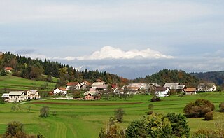
Drenovec pri Bukovju is a settlement in the Municipality of Brežice in eastern Slovenia. It lies in the hills above the right bank of the Sotla River, northeast of Bizeljsko, on the border with Croatia. The area was traditionally part of Lower Styria. It is now included with the rest of the municipality in the Lower Sava Statistical Region. The settlement includes the hamlets of Gornji Drenovec, Lipovec, Trnje, and Gornja Vas.

Hrastje pri Cerkljah in Lower Carniola, Slovenia

Hrastje pri Cerkljah is a small village northwest of Cerklje ob Krki in the Municipality of Brežice in eastern Slovenia. The area was traditionally part of Lower Carniola. It is now included in the Lower Sava Statistical Region.

Prapreče pri Šentjerneju in Lower Carniola, Slovenia

Prapreče pri Šentjerneju is a settlement in the Municipality of Šentjernej in southeastern Slovenia. The entire municipality was traditionally part of Lower Carniola. It is now included in the Southeast Slovenia Statistical Region. It includes the hamlet of Gmajnica.

Bojanja Vas Place in White Carniola, Slovenia

Bojanja Vas is a village in the Municipality of Metlika in the White Carniola area of southeastern Slovenia, next to the border with Croatia. The entire area is part of the traditional region of Lower Carniola and is now included in the Southeast Slovenia Statistical Region.

Boršt, Metlika Place in White Carniola, Slovenia

Boršt is a small settlement on the left bank of the Kolpa River in the Municipality of Metlika in the White Carniola area of southeastern Slovenia. The entire area is part of the traditional region of Lower Carniola and is now included in the Southeast Slovenia Statistical Region.

Jugorje pri Metliki in White Carniola, Slovenia

Jugorje pri Metliki is a small settlement in the Municipality of Metlika in the White Carniola area of southeastern Slovenia. The entire area is part of the traditional region of Lower Carniola and is now included in the Southeast Slovenia Statistical Region.

Gornji Suhor pri Vinici in White Carniola, Slovenia

Gornji Suhor pri Vinici is a village on the route from Dragatuš to Vinica in the Municipality of Črnomelj in the White Carniola area of southeastern Slovenia. The area is part of the traditional region of Lower Carniola and is now included in the Southeast Slovenia Statistical Region.

Grič pri Dobličah in White Carniola, Slovenia

Grič pri Dobličah is a settlement southwest of Dobliče in the Municipality of Črnomelj in the White Carniola area of southeastern Slovenia. The area is part of the traditional region of Lower Carniola and is now included in the Southeast Slovenia Statistical Region. Hamlets of the village includes Dolnji Grič, which comprises the village core, and Gornji Grič, as well as Vidoše and Kralji. Vidoše has only a few houses along the road from Bistrica to Mavrlen. Vidoše was formerly a hamlet of Doblička Gora.

Lavrica Place in Lower Carniola, Slovenia

Lavrica is a settlement in central Slovenia. It lies southeast of the capital Ljubljana in the Municipality of Škofljica. The railway line from Ljubljana to Novo Mesto runs through the settlement. The municipality is part of the traditional region of Lower Carniola and is now included in the Central Slovenia Statistical Region. It includes the hamlets of Daljna Vas, Babna Gorica, Srednja Vas, and Sela pri Rudniku.

Veliki Lipoglav Place in Lower Carniola, Slovenia

Veliki Lipoglav is a small settlement in the hills southeast of Ljubljana in central Slovenia. It belongs to the City Municipality of Ljubljana and is part of the traditional region of Lower Carniola. It is now included with the rest of the municipality in the Central Slovenia Statistical Region.

Tenetiše, Litija Place in Lower Carniola, Slovenia

Tenetiše is a settlement on the right bank of the Sava River east of Litija in central Slovenia. Traditionally the area was part of Lower Carniola and is now included with the rest of the Municipality of Litija in the Central Sava Statistical Region.

Gorenja Vas pri Šmarjeti in Lower Carniola, Slovenia

Gorenja Vas pri Šmarjeti is a village immediately west of Šmarjeta in the Municipality of Šmarješke Toplice in southeastern Slovenia. The area is part of the historical region of Lower Carniola. The municipality is now included in the Southeast Slovenia Statistical Region. The settlement includes the hamlets of Mevce to the northwest, Podkrajec to the north, and Dolina, Hrib, and Ravnik to the west.

Zavinek Place in Lower Carniola, Slovenia

Zavinek is a small settlement south of Škocjan in the traditional region of Lower Carniola in southeastern Slovenia. Within the Municipality of Škocjan, it belongs to the Local Community of Škocjan. The area is part of the Southeast Slovenia Statistical Region.

Tlake, Grosuplje Place in Lower Carniola, Slovenia

Tlake is a settlement in the Municipality of Grosuplje in central Slovenia. It lies west of Šmarje–Sap on the road to Škofljica. The area is part of the historical region of Lower Carniola. The municipality is now included in the Central Slovenia Statistical Region. The settlement consists of two parts: Spodnje Tlake and Zgornje Tlake.

Bukovica, Ivančna Gorica in Lower Carniola, Slovenia

Bukovica is a village in the Municipality of Ivančna Gorica in central Slovenia. The area is part of the historical region of Lower Carniola. The municipality is now included in the Central Slovenia Statistical Region. It includes the hamlets of Brezovec, Cerovec, Gornji Vrh, Potok, and Ukajdol.

Gabrje pri Stični Place in Lower Carniola, Slovenia

Gabrje pri Stični is a settlement just north of Stična in the Municipality of Ivančna Gorica in central Slovenia. The area is part of the historical region of Lower Carniola. The municipality is now included in the Central Slovenia Statistical Region. The settlement includes the hamlets of Kurja Vas, Potok, Pungrt, and Nograd.

Laze pri Boštanju in Lower Carniola, Slovenia

Laze pri Boštanju is a dispersed settlement in the hills south of Boštanj in the Municipality of Sevnica in central Slovenia. The area is part of the historical region of Lower Carniola. The municipality is now included in the Lower Sava Statistical Region. It includes the hamlets of Rekštanj and Zapuže.

References

  1. Statistical Office of the Republic of Slovenia
  2. 1 2 Leksikon občin kraljestev in dežel zastopanih v državnem zboru, vol. 6: Kranjsko. 1906. Vienna: C. Kr. Dvorna in Državna Tiskarna, p. 14.
  3. 1 2 Intelligenzblatt zur Laibacher Zeitung, no. 141. 24 November 1849, p. 34.
  4. Metlika municipal site
  5. Spremembe naselij 1948–95. 1996. Database. Ljubljana: Geografski inštitut ZRC SAZU, DZS.
  6. Snoj, Marko. 2009. Etimološki slovar slovenskih zemljepisnih imen. Ljubljana: Modrijan and Založba ZRC, p. 401.
  7. Savnik, Roman, ed. 1971. Krajevni leksikon Slovenije, vol. 2. Ljubljana: Državna založba Slovenije. pp. 451–452.