Klošter

Last updated
Klošter
Slovenia location map.svg
Red pog.svg
Klošter
Location in Slovenia
Coordinates: 45°37′3.66″N15°14′23.16″E / 45.6176833°N 15.2397667°E / 45.6176833; 15.2397667 Coordinates: 45°37′3.66″N15°14′23.16″E / 45.6176833°N 15.2397667°E / 45.6176833; 15.2397667
Country Flag of Slovenia.svg Slovenia
Traditional region White Carniola
Statistical region Southeast Slovenia
Municipality Metlika
Area
  Total 0.71 km2 (0.27 sq mi)
Elevation 156.7 m (514.1 ft)
Population (2002)
  Total 80
[1]

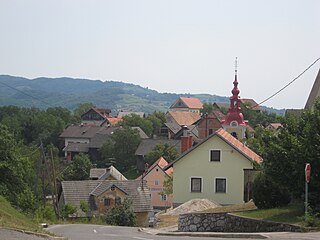
Klošter (pronounced  [ˈkloːʃtəɾ] ; German : Kloster [2] ) is a settlement on the left bank of the Lahinja River in the Municipality of Metlika in the White Carniola area of southeastern Slovenia. The entire area is part of the traditional region of Lower Carniola and is now included in the Southeast Slovenia Statistical Region. [3]

German language West Germanic language

German is a West Germanic language that is mainly spoken in Central Europe. It is the most widely spoken and official or co-official language in Germany, Austria, Switzerland, South Tyrol (Italy), the German-speaking Community of Belgium, and Liechtenstein. It is also one of the three official languages of Luxembourg and a co-official language in the Opole Voivodeship in Poland. The languages which are most similar to German are the other members of the West Germanic language branch: Afrikaans, Dutch, English, the Frisian languages, Low German/Low Saxon, Luxembourgish, and Yiddish. There are also strong similarities in vocabulary with Danish, Norwegian and Swedish, although those belong to the North Germanic group. German is the second most widely spoken Germanic language, after English.

Lahinja river in Slovenia

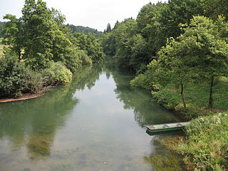
The Lahinja is a river in White Carniola, the extreme southeastern part of Slovenia. It is 34 kilometres (21 mi) long and originates from several karst springs at the end of a steephead valley between the villages of Knežina, Belčji Vrh, and Mali Nerajec.

Municipality An administrative division having corporate status and usually some powers of self-government or jurisdiction

A municipality is usually a single administrative division having corporate status and powers of self-government or jurisdiction as granted by national and regional laws to which it is subordinate. It is to be distinguished (usually) from the county, which may encompass rural territory or numerous small communities such as towns, villages and hamlets.

The local church, built north of the settlement, at the confluence of the Krupa with the Lahinja, is dedicated to the Virgin Mary and belongs to the Parish of Podzemelj. It was built in the second half of the 15th century and was remodelled in the Baroque syle when it was extended in the 17th century. The belfry was added in 1828. [4]

Church (building) building constructed for Christian worship

A church building or church house, often simply called a church, is a building used for Christian religious activities, particularly for Christian worship services. The term is often used by Christians to refer to the physical buildings where they worship, but it is sometimes used to refer to buildings of other religions. In traditional Christian architecture, the church is often arranged in the shape of a Christian cross. When viewed from plan view the longest part of a cross is represented by the aisle and the junction of the cross is located at the altar area.

Mary, mother of Jesus religious figure and mother of Jesus of Nazareth

Mary was a 1st-century BC Galilean Jewish woman of Nazareth, and the mother of Jesus, according to the New Testament and the Quran.

A parish is a territorial entity in many Christian denominations, constituting a division within a diocese. A parish is under the pastoral care and clerical jurisdiction of a parish priest, who might be assisted by one or more curates, and who operates from a parish church. Historically, a parish often covered the same geographical area as a manor. Its association with the parish church remains paramount.

Related Research Articles

Metlika Town and Municipality in Slovenia

Metlika is a town and municipality in the southeastern Slovenia. It lies on the left bank of the Kolpa River on the border with Croatia. The municipality is at the heart of the area of White Carniola, the southeastern part of the traditional region of Lower Carniola. It is now included in the Southeast Slovenia Statistical Region.

Bereča Vas Place in White Carniola, Slovenia

Bereča Vas is a settlement in the Municipality of Metlika in the White Carniola area of southeastern Slovenia. The entire area is part of the traditional region of Lower Carniola and is now included in the Southeast Slovenia Statistical Region.

Boldraž in White Carniola, Slovenia

Boldraž is a small settlement north of the town of Metlika in the White Carniola area of southeastern Slovenia. The entire area is part of the traditional region of Lower Carniola and is now included in the Southeast Slovenia Statistical Region.

Drage, Metlika in White Carniola, Slovenia

Drage is a settlement in the foothills of the Gorjanci range in the Municipality of Metlika in southeastern Slovenia. The entire area is part of the traditional region of Lower Carniola and is now included in the Southeast Slovenia Statistical Region.

Drašiči Place in White Carniola, Slovenia

Drašiči is a village in the Municipality of Metlika in the White Carniola area of southeastern Slovenia, next to the border with Croatia. The entire area is part of the traditional region of Lower Carniola and is now included in the Southeast Slovenia Statistical Region.

Geršiči in White Carniola, Slovenia

Geršiči is a small settlement in the hills north of Gradac in the Municipality of Metlika in the White Carniola area of southeastern Slovenia. The railway line from Novo Mesto to Metlika runs just north of the settlement. The entire area is part of the traditional region of Lower Carniola and is now included in the Southeast Slovenia Statistical Region.

Grabrovec, Metlika in White Carniola, Slovenia

Grabrovec is a settlement in the Municipality of Metlika in the White Carniola area of southeastern Slovenia. The entire area is part of the traditional region of Lower Carniola and is now included in the Southeast Slovenia Statistical Region.

Krasinec Place in White Carniola, Slovenia

Krasinec is a settlement on the left bank of the Kolpa River in the Municipality of Metlika in the White Carniola area of southeastern Slovenia, right on the border with Croatia. The area is part of the traditional region of Lower Carniola and is now included in the Southeast Slovenia Statistical Region.

Krivoglavice in White Carniola, Slovenia

Krivoglavice is a settlement on the left bank of the Lahinja River in the Municipality of Metlika in the White Carniola area of southeastern Slovenia. The railway line from Novo Mesto to Metlika runs just north of the settlement. The area is part of the traditional region of Lower Carniola and is now included in the Southeast Slovenia Statistical Region.

Okljuka in White Carniola, Slovenia

Okljuka is a small settlement on the right bank of the Lahinja River, south of Gradac in the Municipality of Metlika in the White Carniola area of southeastern Slovenia. The entire area is part of the traditional region of Lower Carniola and is now included in the Southeast Slovenia Statistical Region.

Primostek in White Carniola, Slovenia

Primostek is a village in the Municipality of Metlika in the White Carniola area of southeastern Slovenia. It lies on the right bank of the Lahinja River, close to its confluence with the Kolpa River, next to the border with Croatia. The entire area is part of the traditional region of Lower Carniola and is now included in the Southeast Slovenia Statistical Region.

Radovica in White Carniola, Slovenia

Radovica is a village in the Municipality of Metlika in the White Carniola area of southeastern Slovenia, next to the border with Croatia. The area is part of the traditional region of Lower Carniola and is now included in the Southeast Slovenia Statistical Region.

Radoviči in White Carniola, Slovenia

Radoviči is a settlement on the left bank of the Kolpa River, east of the town of Metlika in the White Carniola area of southeastern Slovenia. The entire area is part of the traditional region of Lower Carniola and is now included in the Southeast Slovenia Statistical Region.

Rosalnice Place in White Carniola, Slovenia

Rosalnice is a village on the left bank of the Kolpa River, east of the town of Metlika in the White Carniola area of southeastern Slovenia, right on the border with Croatia. The railway line from Novo Mesto to Karlovac runs through the settlement before it crosses the Kolpa River into Croatia. The entire area is part of the traditional region of Lower Carniola and is now included in the Southeast Slovenia Statistical Region.

Trnovec, Metlika in White Carniola, Slovenia

Trnovec is a village in the Municipality of Metlika in the White Carniola area of southeastern Slovenia. The entire area is part of the traditional region of Lower Carniola and is now included in the Southeast Slovenia Statistical Region.

Vidošiči in White Carniola, Slovenia

Vidošiči is a dispersed settlement in the Municipality of Metlika in the White Carniola area of southeastern Slovenia, next to the border with Croatia. The area is part of the traditional region of Lower Carniola and is now included in the Southeast Slovenia Statistical Region.

Zemelj in White Carniola, Slovenia

Zemelj is a small settlement on the left bank of the Kolpa River in the Municipality of Metlika in the White Carniola area of southeastern Slovenia. The area is part of the traditional region of Lower Carniola and is now included in the Southeast Slovenia Statistical Region.

Mala Lahinja in White Carniola, Slovenia

Mala Lahinja is a settlement at the source of the Lahinja River south of Dragatuš in the Municipality of Črnomelj in the White Carniola area of southeastern Slovenia. The area is part of the traditional region of Lower Carniola and is now included in the Southeast Slovenia Statistical Region.

Vojna Vas Place in White Carniola, Slovenia

Vojna Vas is a settlement on the left bank of the Lahinja River east of Črnomelj in the White Carniola area of southeastern Slovenia. The area is part of the traditional region of Lower Carniola and is now included in the Southeast Slovenia Statistical Region.

Vranoviči in White Carniola, Slovenia

Vranoviči is a settlement on the left bank of the Lahinja River in the Municipality of Črnomelj in the White Carniola area of southeastern Slovenia. The railway line from Črnomelj to Metlika runs alongside the main road through the settlement. The area is part of the traditional region of Lower Carniola and is now included in the Southeast Slovenia Statistical Region.

References

  1. Statistical Office of the Republic of Slovenia
  2. Leksikon občin kraljestev in dežel zastopanih v državnem zboru, vol. 6: Kranjsko. 1906. Vienna: C. Kr. Dvorna in Državna Tiskarna, p. 13.
  3. Metlika municipal site
  4. Slovenian Ministry of Culture register of national heritage reference number ešd 2125