Krasinec | |
---|---|
Coordinates: 45°35′18.06″N15°16′44.81″E / 45.5883500°N 15.2791139°E Coordinates: 45°35′18.06″N15°16′44.81″E / 45.5883500°N 15.2791139°E | |
Country | |
Traditional region | White Carniola |
Statistical region | Southeast Slovenia |
Municipality | Metlika |
Area | |
• Total | 4.77 km2 (1.84 sq mi) |
Elevation | 145.4 m (477.0 ft) |
Population (2002) | |
• Total | 215 |
[1] |
Krasinec (pronounced [kɾaˈsiːnəts] ; German : Krassinz [2] ) is a settlement on the left bank of the Kolpa River in the Municipality of Metlika in the White Carniola area of southeastern Slovenia, right on the border with Croatia. The area is part of the traditional region of Lower Carniola and is now included in the Southeast Slovenia Statistical Region. [3]
German is a West Germanic language that is mainly spoken in Central Europe. It is the most widely spoken and official or co-official language in Germany, Austria, Switzerland, South Tyrol (Italy), the German-speaking Community of Belgium, and Liechtenstein. It is also one of the three official languages of Luxembourg and a co-official language in the Opole Voivodeship in Poland. The languages which are most similar to German are the other members of the West Germanic language branch: Afrikaans, Dutch, English, the Frisian languages, Low German/Low Saxon, Luxembourgish, and Yiddish. There are also strong similarities in vocabulary with Danish, Norwegian and Swedish, although those belong to the North Germanic group. German is the second most widely spoken Germanic language, after English.
A municipality is usually a single administrative division having corporate status and powers of self-government or jurisdiction as granted by national and regional laws to which it is subordinate. It is to be distinguished (usually) from the county, which may encompass rural territory or numerous small communities such as towns, villages and hamlets.
Metlika is a town and municipality in the southeastern Slovenia. It lies on the left bank of the Kolpa River on the border with Croatia. The municipality is at the heart of the area of White Carniola, the southeastern part of the traditional region of Lower Carniola. It is now included in the Southeast Slovenia Statistical Region.
Probable Roman finds have been discovered in the area, testifying to its early settlement. According to Johann Weikhard von Valvasor, the nobleman Ivan Adam Burgstall built a manor near the village, and in 1666 also established a manor farm for raising livestock. Between the manor house and the farm there was also a pond and dovecote. By the 18th century, the manor owned three farms in the village and was part of the dominion of Pobrežje. No trace remains of the manor today. In 1899 a historical vineyard cottage in the village was destroyed by fire. During the Second World War, a Partisan airfield was located 1 kilometer (0.62 mi) from the village. It was used by American and British aircraft from fall 1944 to April 1945 to supply war material to the Partisan forces and to evacuate wounded soldiers and British paratroopers. [4]
Johann Weikhard Freiherr von Valvasor or Johann Weichard Freiherr von Valvasor or simply Valvasor was a natural historian and polymath from Carniola, present-day Slovenia, and a fellow of the Royal Society in London.
A dovecote or dovecot or doocot is a structure intended to house pigeons or doves. Dovecotes may be free-standing structures in a variety of shapes, or built into the end of a house or barn. They generally contain pigeonholes for the birds to nest. Pigeons and doves were an important food source historically in Western Europe and were kept for their eggs, flesh, and dung.
The Yugoslav Partisans, or the National Liberation Army, officially the National Liberation Army and Partisan Detachments of Yugoslavia, was the Communist-led resistance to the Axis powers in occupied Yugoslavia during World War II.
The local church is dedicated to Saint Anthony the Hermit and belongs to the Parish of Podzemelj. It was built in the 18th century. [5]
A church building or church house, often simply called a church, is a building used for Christian religious activities, particularly for Christian worship services. The term is often used by Christians to refer to the physical buildings where they worship, but it is sometimes used to refer to buildings of other religions. In traditional Christian architecture, the church is often arranged in the shape of a Christian cross. When viewed from plan view the longest part of a cross is represented by the aisle and the junction of the cross is located at the altar area.
Anthony the Hermit, also known as Antony of Lérins, is a Christian saint. He was born in the ancient Roman province of Valeria, then part of the Hunnic Empire. When he was eight years old, his father died and he was entrusted to the care of the holy Abbot Severinus of Noricum, in modern-day Austria. Upon the death of Severinus in 482, Anthony was sent to Germany and put in the care of his uncle, Constantius, an early Bishop of Lorsch. While there, Anthony is thought to have become a monk at the age of twenty.
A parish is a territorial entity in many Christian denominations, constituting a division within a diocese. A parish is under the pastoral care and clerical jurisdiction of a parish priest, who might be assisted by one or more curates, and who operates from a parish church. Historically, a parish often covered the same geographical area as a manor. Its association with the parish church remains paramount.
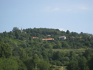
Volčji Potok is a village on a terrace on the left bank of the Kamnik Bistrica River in the Municipality of Kamnik in the Upper Carniola region of Slovenia.
Križevska Vas is a small settlement in the Municipality of Dol pri Ljubljani in the eastern Upper Carniola region of Slovenia.
Bojanja Vas is a village in the Municipality of Metlika in the White Carniola area of southeastern Slovenia, next to the border with Croatia. The entire area is part of the traditional region of Lower Carniola and is now included in the Southeast Slovenia Statistical Region.
Boršt is a small settlement on the left bank of the Kolpa River in the Municipality of Metlika in the White Carniola area of southeastern Slovenia. The entire area is part of the traditional region of Lower Carniola and is now included in the Southeast Slovenia Statistical Region.
Gornji Suhor pri Metliki is a settlement in the Municipality of Metlika in the White Carniola area of southeastern Slovenia, right on the border with Croatia. The entire area is part of the traditional region of Lower Carniola and is now included in the Southeast Slovenia Statistical Region.
Krašnji Vrh is a small village in the Municipality of Metlika in the White Carniola area of southeastern Slovenia, right on the border with Croatia. The area is part of the traditional region of Lower Carniola and is now included in the Southeast Slovenia Statistical Region.
Podzemelj is a village on the left bank of the Kolpa River in the Municipality of Metlika in the White Carniola area of southeastern Slovenia, next to the border with Croatia. The area is part of the traditional region of Lower Carniola and is now included in the Southeast Slovenia Statistical Region.
Kvasica is a settlement on main road from Črnomelj to Dragatuš in the White Carniola area of southeastern Slovenia. The area is part of the traditional region of Lower Carniola and is now included in the Southeast Slovenia Statistical Region.
Ručetna Vas is a settlement north of Črnomelj in the White Carniola area of southeastern Slovenia. The area is part of the traditional region of Lower Carniola and is now included in the Southeast Slovenia Statistical Region.
Stara Cerkev is a village northwest of Kočevje in southern Slovenia. The area is part of the traditional region of Lower Carniola and is now included in the Southeast Slovenia Statistical Region.
Zamostec is a settlement east of Sodražica in southern Slovenia. The area is part of the traditional region of Lower Carniola and is now included in the Southeast Slovenia Statistical Region. The settlement includes the hamlets of Vranove Njivice, Podgora, Mandrge, Podvas, Grdi Dol, and Bravčji Vrt.
Zapotok is a settlement in the Municipality of Sodražica in southern Slovenia. The area is part of the traditional region of Lower Carniola and is now included in the Southeast Slovenia Statistical Region. It includes the hamlets of Mali Zapotok, Veliki Zapotok, and Sveti Marko.
Janče is a dispersed settlement in the hills south of the Sava River east of the capital Ljubljana in central Slovenia. It belongs to the City Municipality of Ljubljana. It was part of the traditional region of Lower Carniola and is now included with the rest of the municipality in the Central Slovenia Statistical Region.
Jevnica is a settlement on the right bank of the Sava River in the Municipality of Litija in central Slovenia. The railway line from Ljubljana to Zidani Most runs through the settlement. Traditionally the area was part of Lower Carniola and is now included with the rest of the municipality in the Central Sava Statistical Region; until January 2014 the municipality was part of the Central Slovenia Statistical Region.
Gorenja Vas pri Šmarjeti is a village immediately west of Šmarjeta in the Municipality of Šmarješke Toplice in southeastern Slovenia. The area is part of the historical region of Lower Carniola. The municipality is now included in the Southeast Slovenia Statistical Region. The settlement includes the hamlets of Mevce to the northwest, Podkrajec to the north, and Dolina, Hrib, and Ravnik to the west.
Lapinje is a former village in the Municipality of Kočevje in southern Slovenia. The area is part of the traditional region of Lower Carniola and is now included in the Southeast Slovenia Statistical Region. Its territory is now part of the village of Podlesje.
Preža is a village in the Municipality of Kočevje in southern Slovenia. The area is part of the traditional region of Lower Carniola and is now included in the Southeast Slovenia Statistical Region. It no longer has any permanent residents.
Verderb is a former village in the Municipality of Kočevje in southern Slovenia. The area is part of the traditional region of Lower Carniola and is now included in the Southeast Slovenia Statistical Region. Its territory is now part of the village of Podlesje.
Vrtača pri Semiču is a former settlement in the Municipality of Semič in southern Slovenia. The area is part of the traditional region of Lower Carniola and is now included in the Southeast Slovenia Statistical Region. Its territory is now part of the town of Semič.
This article about the Municipality of Metlika in Slovenia is a stub. You can help Wikipedia by expanding it. |