
Mendocino County is a county located on the north coast of the U.S. state of California. As of the 2010 census, the population was 87,841. The county seat is Ukiah.

Mendocino is an unincorporated community in Mendocino County, California, United States. Mendocino is located 9.5 miles (15 km) south of Fort Bragg, at an elevation of 154 feet. The population of the census-designated place (CDP) was 894 at the 2010 census, up from 824 at the 2000 census. The town's name comes from Cape Mendocino, named by early Spanish navigators in honor of Antonio de Mendoza, Viceroy of New Spain. In turn, the etymology of Mendoza is "cold mountain."
Point Arguello is a headland on the Pacific coast, in Santa Barbara County, California near the city of Lompoc. The area was first used by the United States Navy in 1959 for the launch of military and sounding rockets. It was transferred to the United States Air Force in 1964, at which time it became part of Vandenberg Air Force Base.

Cape Mendocino, approximately 200 miles north of San Francisco, is located on the Lost Coast entirely within Humboldt County, California, USA. At 124° 24' 34" W longitude it is the westernmost point on the coast of California. The South Cape Mendocino State Marine Reserve and Sugarloaf Island are immediately offshore, although closed to public access due to their protected status. Sugarloaf Island is cited as California's westernmost island.

Caspar is a census-designated place in Mendocino County, California. It is located on the Pacific Ocean, 4 miles (6.4 km) north of Mendocino, at an elevation of 82 feet (25 m). It is bounded on three sides by state parks: the historic 1909 Point Cabrillo Light Station is nearby to the south, Jug Handle State Natural Reserve lies to the north, and its coast forms Caspar Headlands State Beach. The population was 509 at the 2010 census.

The North Coast of California is the region in Northern California that lies on the Pacific coast between San Francisco Bay and the Oregon border. It commonly includes Mendocino, Humboldt, and Del Norte counties and sometimes includes two counties from the San Francisco Bay area, Marin and Sonoma.

Pulga is an unincorporated community in Butte County, California. It is located along the west slope of the Feather River canyon, at an elevation of 1398 feet. A variant name for the community is Big Bar. Other nearby communities include Mayaro, Poe and Parkhill. The town hosts a Caltrans highway maintenance station along State Route 70 (SR70). The place is at the mouth of the Flea Valley Creek, which gives rise to the toponym.

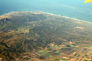
Point Cabrillo Light is a lighthouse in northern California, United States, between Point Arena and Cape Mendocino, just south of the community of Caspar. It has been a federal aid to navigation since 1909. It is part of the California state park system as Point Cabrillo Light Station State Historic Park.

Duncans Point is a cape on the Pacific Coast of northern California in the United States. It is located in Sonoma County at 38.393°N 123.0947°W, approximately 45 miles (70 km) northwest of San Francisco and approximately 20 miles (30 km) west of Santa Rosa.
Card Place is an unincorporated community in Mendocino County, California. It lies at an elevation of 823 feet. Card Place is located at 39°48′29″N123°24′17″W.
Pine Grove is an unincorporated community in Mendocino County, California. It is located 3 miles (4.8 km) north-northwest of Mendocino, at an elevation of 167 feet. On the ocean just west of the community is the Point Cabrillo Light station.

Island Mountain is a resistant formation of volcanic and metavolcanic rock in the Franciscan Assemblage of southwestern Trinity County, California. It was mined for sulfur metal deposits during the first half of the 20th century and was the final obstacle in the construction of a railroad line to Eureka, California in 1914. The name is applied to the range, the peak, a populated place and an abandoned railroad station, tunnel and bridge all but the first located within the S-bend of the Eel River which gave the peak its name.
Camp Noyo is an unincorporated community in Mendocino County, California, United States. There is a camp named after the unincorporated community making it what is the name of the community today Camp Noyo. The settlement was originally a logging camp, and a stop along the California Western Railroad.

Bowling Ball Beach is a part of Schooner Gulch State Beach, in Mendocino County, California, in the United States. It is named for the spherical sandstone concretions found there at low tide.
Abalobadiah Creek is a stream with its mouth on the coast about a mile above the mouth of Ten Mile River on the Pacific Ocean coast of Mendocino County, California. Its source is at 39°35′21″N123°44′26″W at an elevation of 800 feet (240 m) in the coastal mountains.
Abalone Point is a cape in Mendocino County, in the U.S. state of California.

Bridgeport is a former logging town on the coast of Mendocino County, California. Its post office was given the name Miller, as there was already a Bridgeport post office in California.
The Frolic was a brig which sank northeast of Point Cabrillo, near Caspar, California. Historians have called it "the most significant shipwreck on the west coast". Its shipwreck site was listed on the National Register of Historic Places as Frolic (brig) in 1991.
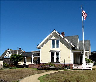
The Kelley House Museum is a house museum in Mendocino, California. It is located at 45007 Albion Street in Mendocino.

