Pointe au Baril, Ontario

Last updated

Sunrise at Pointe Au Baril PointeAuBarilSunrise.jpg
Sunrise at Pointe Au Baril

Pointe au Baril is a community in the Canadian province of Ontario, located on the east coast of Georgian Bay.

Contents

The community is located in the township of The Archipelago in the Parry Sound District.

Pointe au Baril is a popular destination in all four seasons for boating, camping, sport-fishing, snowmobiling, and more. It is made up of a collection of islands, with access to the main land on the eastern shore of Georgian Bay. Pointe au Baril has a permanent population of 200-250 people, but increases to about 8,000 over the summer.

Community name

Pointe au Baril was named after the barrel on the point that originally (1870s) marked the treacherous entry to the main channel from the open water of Georgian Bay. Early fur traders from Penetanguishene apparently lost a canoe near the point. Their canoe included a barrel of whiskey that was found by stranded traders the next spring. After a drinking spree the barrel was left on the point as a beacon. French mariners were soon calling it Pointe-au-Baril. Later this marker was improved to include a lantern in the barrel that would be lit by the first fisherman returning inland to light the way for the rest of the boats.

Pointe au Baril Station

Pointe au Baril may refer to the original Barrel on the Point reference or the actual village, built around a train station, about six nautical miles (11 km, 7 miles) away. Highway 69 follows the same path as the railway and they both run past the east tip of what is known as the Main Channel. This channel is a well marked route from the village to the lighthouse.

The village has a North Shore and a South Shore road but islander travel is by boat. The village is referred to as The Station by most residents. Pointe au Baril Station is well suited for launching water craft and is supported by many marinas and a substantial public dock.

Historic landmarks

The Pointe Au Baril Lighthouse PointeAuBarilLighthouse.jpg
The Pointe Au Baril Lighthouse

Lighthouse

The point is lit by the recently automated lighthouse. This historic lighthouse opens its doors for tours in the summer months. The lighthouse is a part of a light system which includes a range tower (about one half nautical mile behind the lighthouse) and a turn buoy (nearly three nautical miles offshore from the lighthouse) which work together to allow safe passage through the many shoals that cover the eastern coast of Georgian Bay ( 45°33′33″N80°30′13″W / 45.55917°N 80.50361°W / 45.55917; -80.50361 ). The first Lighthouse keeper was Samuel Edward Oldfield (1843-1917) who was appointed in 1889.

Firetower

The Pointe au Baril firetower lookout was erected in the 1920s to detect forest fires. This 80 foot light-steel tower was part of the Parry Sound Fire District tower system. It stood near the centre of the village, just west of the railway tracks and near the bay on a small hill. When aerial fire fighting techniques were employed by the province many of the towers like this one were disassembled in the early 1970s. The footings, however, are still there to this day.

Fishing and logging

Pointe au Baril became a community to support commercial fishing in the 1870s. The last fishing operation based in Pointe au Baril was shut down in the 1980s.

A lumber industry existed in the area during these same years. The pine, hemlock and yellow birch forestry ended in the 1940s, shortly after the end of World War II.

Today

A Pointe Au Baril full moon PointeAuBarilMoonrise.jpg
A Pointe Au Baril full moon

The area is now primarily a cottage community on Highway 69. The channels and islands of the region make it a boating, fishing and islander paradise. It has also become a destination for snowmobiling in the winter months.

Among the many islands there is the historic Ojibway Club founded by Hamilton Davis in 1906 as a hotel. Many of Davis's descendents still summer in Pointe au Baril to this day.

The population grows from a winter low of about 250 to 300 to a summer high of 8000 or more. Additional growth is expected in the future as Highway 400 is extended past the community.

With the demolition of Larry's Tavern for the expansion of the highway, there remains one restaurant, The Haven, which is open all year, The Harbour View, which is only open during the summer months and the Shell Station Deli. There are also two chip wagons located in Pointe au Baril, one open only during the summer, while the other remains open all year.

Community events in Pointe au Baril include the Winter Whirl carnival, held the first weekend in February, Canada Day festivities, and the Pickerel Dinner and Annual Lobster Fest held the third weekend in July. The ducky race is another local festival held in Pointe au Baril organized by the North Eastern Georgian Bay Snowmobile Club right in downtown Pointe au Baril. Summertime events also include Arts on the Bay Dinner theatre in the Pointe au Baril Community Centre.

Pointe au Baril has a community centre with a library in it. The town also offers an ice rink and playground. Pointe au Baril also has a Nursing Station and an Emergency response team.

Pointe au Baril's cottage community is largely water access and is home to many marinas.

Early exploration

The area was explored by Samuel de Champlain in 1615. A monument was erected in the 1940s to commemorate his travels through the area. It can be found near the newly renovated Ojibway Club, a favoured gathering place for many of the islanders.

Transportation

Intercity motor coach service to the community is provided by Ontario Northland along its Toronto–Barrie–Parry Sound–Sudbury route local schedule; it is bypassed by express schedules, but still receives daily service northbound and southbound.

Literature

Pointe au Baril is also a setting of John Irving's novel Last Night in Twisted River , where many of the places are described in the winter setting, including nearby islands.

Pointe au Baril is also mentioned in the short story "Hired Girl" in Alice Munro's collection, 'The View from Castle Rock."

Related Research Articles

<span class="mw-page-title-main">La Pointe, Wisconsin</span> Unincorporated community in Wisconsin, United States

La Pointe is an unincorporated community in the town of La Pointe, Ashland County, Wisconsin, United States. It is on the western shore of Madeline Island, the largest of the Apostle Islands. Downtown La Pointe is adjacent to the Madeline Island Ferry dock. La Pointe has a post office with ZIP code 54850.

<span class="mw-page-title-main">Minocqua, Wisconsin</span> Town in Wisconsin, United States

Minocqua is a town in northwestern Oneida County, Wisconsin, United States. The population was 4,388 as of 2017. The census-designated place of Minocqua and the unincorporated community of Rantz are both located in the town. Minocqua is commonly referred to as "The Island City."

<span class="mw-page-title-main">Georgian Bay</span> Large bay of Lake Huron, Ontario, Canada

Georgian Bay is a large bay of Lake Huron, in the Laurentia bioregion. It is located entirely within the borders of Ontario, Canada. The main body of the bay lies east of the Bruce Peninsula and Manitoulin Island. To its northwest is the North Channel.

<span class="mw-page-title-main">Parry Sound District</span> District in Ontario, Canada

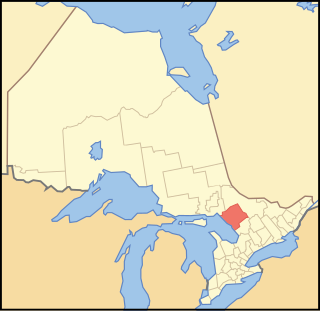
Parry Sound District is a census division of the Canadian province of Ontario. Its boundaries are District of Muskoka to the south, the Sudbury District to the north-northwest, the French River and Lake Nipissing in the north, Nipissing District and North Bay in the north and east and parts of Algonquin Park in the northeast.

<span class="mw-page-title-main">The Archipelago</span> Township in Ontario, Canada

The Archipelago is a township in central Ontario, Canada, along the Georgian Bay in the Parry Sound District.

<span class="mw-page-title-main">Port Carling</span>

Port Carling is an unincorporated community in the Township of Muskoka Lakes in the Canadian province of Ontario. It has been the municipal seat of the township since 1971. It has several hundred year-round residents and is a service centre for thousands of other seasonal residents in the area.

King's Highway 69, commonly referred to as Highway 69, is a provincially maintained north–south highway in the central portion of the Canadian province of Ontario. In conjunction with Highway 400, it links Toronto with the city of Greater Sudbury at Highway 17, via Parry Sound. It is part of the Trans-Canada Highway and the National Highway System. From its southern terminus of Highway 559 at Carling, Highway 69 begins as Highway 400 narrows from a four-laned freeway to a two lane highway. It travels northerly for approximately 68 kilometres (42 mi) to south of the French River before widening back to a divided four lane freeway for approximately 64 kilometres (40 mi) into Sudbury. The final 6 kilometres (3.7 mi) of the route, connecting to Highway 17, is a five lane arterial road that will be converted to freeway as the final phase of the four-laning.

<span class="mw-page-title-main">Ojibway Club</span>

The Ojibway Club is an island community centre located in Pointe au Baril, Ontario, Canada. The club's building is one of few remaining turn-of-the-century lodges built in that part of Ontario.

<span class="mw-page-title-main">Magnetawan</span> Municipality in Ontario, Canada

Magnetawan is a township in the Almaguin Highlands region of the Parry Sound District in the Canadian province of Ontario, as well as the name of the primary population centre in the township.

<span class="mw-page-title-main">Madeline Island</span> Largest of the Apostle Islands in Lake Superior

Madeline Island is an island in Lake Superior. Now part of Ashland County, Wisconsin, it has long been a spiritual center of the Lake Superior Chippewa. Although the largest of the Apostle Islands, it is not included in the Apostle Islands National Lakeshore. It is the only island in the Apostle Island chain open to commercial development and private ownership.

<span class="mw-page-title-main">Imperial Towers</span> Group of lighthouses on Lake Huron, Canada

The Imperial Towers of Ontario were six of the earliest lighthouses built on Lake Huron and Georgian Bay, all constructed primarily of stone, by the Province of Canada. The origin of the designation Imperial is not certain, but some historians speculate that because the towers were public construction built under the colonial administration while Canada was a self-governing colony of Britain, the name would assure at least some funding from the British Empire's Board of Trade.

Waubuno was a side-wheel paddle steamer that conveyed passengers and freight between Collingwood and Parry Sound in the 1860s and 1870s. She sank with all hands during a gale on November 22, 1879, though the exact cause of her sinking is unknown.

<span class="mw-page-title-main">Ontario Highway 529</span> Ontario provincial highway

Secondary Highway 529, commonly referred to as Highway 529, is a provincially maintained secondary highway in the Canadian province of Ontario. Located within Parry Sound District, the highway follows a 25.7-kilometre (16.0 mi) route, from its southern terminus at Highway 69 near Pointe au Baril to its northern terminus at the Highway 69 crossing of the Magnetawan River near Byng Inlet. Two spur routes, Highway 529A and Highway 645, branch off the highway to serve the communities of Bayfield Inlet and Byng Inlet, respectively. The route was established along the present alignment of Highway 529A in 1956. It was relocated in 1961 along the former routing of Highway 69 when a bypass opened through the area, with the former alignment being renumbered as Highway 529A.

<i>Metamora</i> (shipwreck) Wooden tug wrecked in the Georgian Bay area of Ontario

The Metamora was a wooden tug commissioned in 1864 and used predominantly for ferrying passengers and goods in the Georgian Bay area of Ontario. It ran onto a shallow shoal near Turning Island in Georgian Bay on July 30, 1907, caught fire and sank in six feet of water.

Crooked Lake is a recreational lake located in the south-eastern region of the Canadian province of Saskatchewan. It is part of a chain of lakes in the Qu'Appelle Valley and, like many of the other lakes in the valley, there's a dam at the eastern end that controls water levels.

SS <i>Midland City</i> Canadian passenger and cargo vessel on the Great Lakes

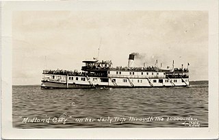
SS Midland City was originally a Canadian side-wheel steamboat that provided passenger and cargo transportation on the Great Lakes from 1871 until 1955. Originally named Maud, then America, she underwent several extensive refits over her 84-year service, and saw several owners. The ship was intentionally run aground and burnt to the waterline in 1955 near the mouth of the Wye River in Midland Bay. The wreck is intact and visible above the water to this day, where it acts as a breakwater for the Wye Heritage Marina and local attraction.

Shawanaga First Nation is an Anishinaabe First Nation band government in central Ontario near Nobel. Its reserves include:

References

    Coordinates: 45°33′38″N80°30′12″W / 45.56056°N 80.50333°W / 45.56056; -80.50333