Pointe des Berons | |
---|---|
Highest point | |
Elevation | 2,954 m (9,692 ft) |
Prominence | 24 m (79 ft) [1] |
Coordinates | 46°00′22″N6°59′04″E / 46.00611°N 6.98444°E Coordinates: 46°00′22″N6°59′04″E / 46.00611°N 6.98444°E |
Geography | |
Location | Valais, Switzerland Haute-Savoie, France |
Parent range | Mont Blanc Massif |
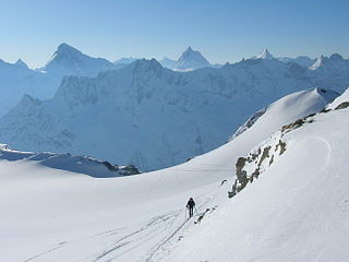
The Pointe des Berons is a mountain of the Mont Blanc Massif, located on the border between Switzerland and France. It lies approximately halfway between the Col de Balme and the Aiguille du Tour. The east (Swiss) side is covered by the Glacier des Berons.
A mountain is a large landform that rises above the surrounding land in a limited area, usually in the form of a peak. A mountain is generally steeper than a hill. Mountains are formed through tectonic forces or volcanism. These forces can locally raise the surface of the earth. Mountains erode slowly through the action of rivers, weather conditions, and glaciers. A few mountains are isolated summits, but most occur in huge mountain ranges.
Switzerland, officially the Swiss Confederation, is a country situated in western, central, and southern Europe. It consists of 26 cantons, and the city of Bern as the seat of the federal authorities. The sovereign state is a federal republic bordered by Italy to the south, France to the west, Germany to the north, and Austria and Liechtenstein to the east. Switzerland is a landlocked country geographically divided between the Alps, the Swiss Plateau and the Jura, spanning a total area of 41,285 km2 (15,940 sq mi). While the Alps occupy the greater part of the territory, the Swiss population of approximately 8.5 million people is concentrated mostly on the plateau, where the largest cities are to be found: among them are the two global cities and economic centres Zürich and Geneva.
France, officially the French Republic, is a country whose territory consists of metropolitan France in Western Europe and several overseas regions and territories. The metropolitan area of France extends from the Mediterranean Sea to the English Channel and the North Sea, and from the Rhine to the Atlantic Ocean. It is bordered by Belgium, Luxembourg and Germany to the northeast, Switzerland and Italy to the east, and Andorra and Spain to the south. The overseas territories include French Guiana in South America and several islands in the Atlantic, Pacific and Indian oceans. The country's 18 integral regions span a combined area of 643,801 square kilometres (248,573 sq mi) and a total population of 67.3 million. France, a sovereign state, is a unitary semi-presidential republic with its capital in Paris, the country's largest city and main cultural and commercial centre. Other major urban areas include Lyon, Marseille, Toulouse, Bordeaux, Lille and Nice.
The Grandes Jorasses is a mountain in the Mont Blanc massif, on the boundary between Haute-Savoie in France and Aosta Valley in Italy.
The Vanoise massif is a mountain range of the Graian Alps, located in the Western Alps. After the Mont Blanc Massif and the Massif des Écrins it is the third highest massif in France, reaching a height of 3,885m at the summit of Grande Casse. It lies between Tarentaise Valley to the north and the Maurienne valley in the south. The range is the site of France's first National Park in 1963, the Vanoise National Park. The ski resorts of Tignes and Val-d'Isère and the 2,770m high Col de l'Iseran are located in the eastern part of the range.
The Aiguille de la Tsa is a mountain of the Swiss Pennine Alps, overlooking Arolla in the canton of Valais. It lies on the range culminating at the Dent de Perroc, between the valley of Arolla and the Mont Miné Glacier.
The Pointe d'Orny is a mountain of the Mont Blanc massif, located west of Orsières in the canton of Valais. It lies north-east of the Plateau du Trient.
The Pointe d'Otemma is a mountain of the Swiss Pennine Alps, located south of the lake of Mauvoisin in the canton of Valais. It lies at western end of the chain separating the Brenay Glacier from the Otemma Glacier.
The Pointe de Vouasson is a mountain of the Swiss Pennine Alps, overlooking Lac des Dix in the canton of Valais. It lies between the valleys of Hérémence (west) and Arolla (east), north of the Aiguilles Rouges d'Arolla.
The Pointe de Zinal is a mountain of the Swiss Pennine Alps, located south of Zinal in the canton of Valais. It is situated east of the Dent Blanche, between the valleys of Zinal and Zmutt (Zermatt).
The Pointe Allobrogia is a mountain of the Mont Blanc massif, overlooking the Col Ferret on the border between Italy and Switzerland. It lies at the southern end of the range south-east of Mont Dolent.
The Pointe des Grands is a mountain of the Mont Blanc Massif, located on the border between France and Switzerland, north-west of the Aiguille du Tour.
The Pointe des Plines is a minor peak on the east edge of the Mont Blanc massif, close to the Aiguille Dorees, and overlooking the Saleina Glacier in the canton of Valais.
The Pointe de Barasson is a mountain of the Swiss Pennine Alps, located on the border between Switzerland and Italy. It lies between the Great St Bernard Pass and Mont Vélan.
The Pointe de Drône is a mountain of the Pennine Alps, located on the border between Italy and Switzerland. It lies west of the Great St. Bernard Pass.
The Grande Pointe des Planereuses is a mountain of the Mont Blanc massif, located west of Praz de Fort in the canton of Valais, Switzerland. It lies on the range south of the Saleina Glacier.
The Pointe des Genevois is a mountain of the Swiss Pennine Alps, overlooking Arolla in the canton of Valais. It lies just south of the higher summit of the Dent de Perroc.
Pointe Kurz is a mountain of the Mont Blanc Massif, located on the border between France and Switzerland. It lies between the glaciers of Argentière and L'A Neuve, west of La Fouly, the closest locality.
The Pointe des Ecandies is a mountain of the Mont Blanc Massif, located between Trient and Champex in the canton of Valais. It is located north of the Pointe d'Orny and east of the Trient Glacier.
The Pointe Sud de Moming is a mountain of the Swiss Pennine Alps, located west of Täsch in the canton of Valais. It lies on the range between the Weisshorn and the Zinalrothorn, south of the Col de Moming.
The Pointe des Mossettes is a mountain of the Chablais Alps, overlooking Les Crosets in the Swiss canton of Valais. The French border runs west of the summit on a straight line, although the mountain lies on the main watershed between the Dranse river basin and the Val d'Illiez.
The Pointe de la Plaine Morte is a mountain of the Bernese Alps, located on the border between the Swiss cantons of Bern and Valais. It overlooks the large and flat glacier named Plaine Morte Glacier, from the south-west side.
The Vanil de l'Ecri is a mountain of the Swiss Prealps, located on the border between the cantons of Fribourg and Vaud. Reaching a height of 2,376 metres above sea level, it is both the second highest summit of the Vanil Noir massif and the canton of Fribourg. The mountain lies between the Pointe de Paray and the Vanil Noir.
This Valais location article is a stub. You can help Wikipedia by expanding it. |