
The Wellington Region is a local-government region of New Zealand that occupies the southern end of the North Island. The region covers an area of 8,049 square kilometres (3,108 sq mi), and has a population of 542,000.
Wairarapa, a geographical region of New Zealand, lies in the south-eastern corner of the North Island, east of metropolitan Wellington and south-west of the Hawke's Bay Region. It is lightly populated, having several rural service towns, with Masterton being the largest. It is named after its largest lake, Lake Wairarapa.
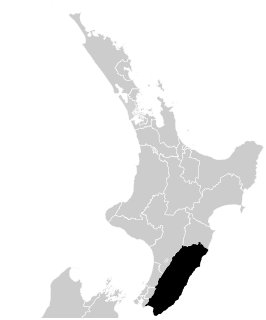
The South Wairarapa District is an area at the south-east tip of the North Island of New Zealand governed by the South Wairarapa District Council. The district comprises the southernmost part of the Wairarapa, and is part of the Wellington Region.

Carterton is a small town in the Wellington Region of New Zealand and the seat of the Carterton District. It lies in a farming area of the Wairarapa in New Zealand's North Island. It is located 14 kilometres (8.7 mi) southwest of Masterton and 80 kilometres (50 mi) northeast of Wellington. The town has a population of 5,800, out of a total district population of 9,960.

Masterton, a large town in the Greater Wellington Region of New Zealand, operates as the seat of the Masterton District. It is the largest town in the Wairarapa, a region separated from Wellington by the Rimutaka ranges. It stands on the Waipoua stream between the Ruamahunga and Waingawa Rivers - 100 kilometres north-east of Wellington and 39.4 kilometres south of Eketahuna.

The Tararua District is an area near the south-east corner of New Zealand's North Island that is administered by the Tararua District Council. It has a population of 18,900, and an area of 4,360.56 km². The Tararua District Council was created by the amalgamation of the Dannevirke Borough, Eketahuna County Council, Pahiatua Borough Council, Pahiatua County Council and Woodville District Council in the 1989 local government reforms.

Featherston is a town in the South Wairarapa District, in the Wellington Region of New Zealand's North Island. It is at the eastern foothills of Remutaka Range close to the northern shore of Lake Wairarapa, 63 km (39 mi) north-east of central Wellington and 37 km (23 mi) south-west of Masterton.

The Remutaka Range is the southernmost range of a mountain chain in the lower North Island of New Zealand. The chain continues north into the Tararua, then Ruahine Ranges, running parallel with the east coast between Wellington and East Cape.

The Wairarapa-Bush Rugby Football Union is the body that regulates rugby union in Masterton, New Zealand. It was formed in 1971 with the amalgamation of the Wairapapa and Bush Unions.

Longbush is a rural community in the Carterton District, Wairarapa of New Zealand's North Island. It is located in a valley southeast of the town of Carterton, and nearby settlements include Gladstone and Ponatahi to the north.
Gladstone is a lightly populated locality in the Carterton District of New Zealand's North Island, located on the Mangahuia Stream near where the Tauweru River joins the Ruamahanga River. The nearest town is Carterton 15 kilometres to the northwest, and nearby settlements include Ponatahi to the west and Longbush to the south. It was named after British prime minister William Ewart Gladstone.
The Tauweru River, sometimes called the Taueru River, is a river in the Wairarapa region of New Zealand's North Island. It drains from the pastoral eastern highlands of the Wairarapa and joins the Ruamahanga River just north of the Gladstone Road bridge into Gladstone, southeast of Carterton. The river's name is Māori for "hanging in clusters" and named after it is the town of Tauweru, located along the middle reaches of the river east of Masterton.
Te Whiti, formerly Te Whiti o Tu in the nineteenth century, is a rural community in the Wairarapa region of New Zealand's North Island. Its status has been under dispute and threatened in the twentieth century, and Land Information New Zealand acknowledges Te Whiti solely as a homestead. Its full former name means "the place of crossing" in the Māori language, reflecting its location near a natural crossing of the Ruamahanga River where it is met by the Waingawa River. The Ruamahunga River runs north and west of the locality and is also met by the Tauweru River that flows across the south of Te Whiti. In relation to major Wairarapa centres, Te Whiti is south of Masterton and east of Carterton, while nearby communities include Te Whanga to the east and Gladstone and Longbush to the south. The Maungaraki Range is also nearby.

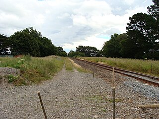
Carterton railway station is a suburban railway station serving Carterton, New Zealand. The station is located on the Wairarapa Line, 76.6 km (47.6 mi) north of Wellington and 14.4 km (8.9 mi) south of Masterton. The Wairarapa Connection serves the station several times daily with services to Wellington and Masterton. The station has a single seven-car side platform.
The Wairarapa Railway Restoration Society is a railway heritage and preservation community group in the town of Carterton, in the Wairarapa district of New Zealand's North Island. The society has leased the Carterton railway station building through the Carterton District Council, though it is owned by the New Zealand Railways Corporation.

Waingawa railway station is a station on the Wairarapa Line in the Masterton district of New Zealand's North Island. It is located about 1 kilometre (0.62 mi) south of the Waingawa River and is situated in a heavy industrial area. It served passenger trains until 1992 and now only handles freight.
Wairarapa South was a New Zealand parliamentary electorate from 1881 to 1887.

Dalefield railway station was a station on the Wairarapa Line that served the small rural community of Dalefield, just south of Carterton in the Wairarapa region of New Zealand’s North Island. It survived for just over a century from when the line opened in 1880 until it was closed in 1981.
Clareville railway station was a flag station serving the small settlement of Clareville, north of Carterton in the Wairarapa region of New Zealand's North Island. It survived for nine decades from when it opened in 1880 until closure to all traffic in 1970.
Mangatarere Stream is a small gravel-bed stream in central Wairarapa, New Zealand, that originates in the Tararua Ranges. It is located close to the township of Carterton and is the main tributary to the Waiohine River. The Waiohine flows into the Ruamahanga River, southeast of Greytown.