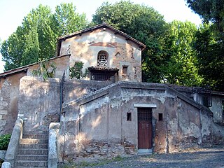
Ponte della Magliana

Last updated

Ponte della Magliana
PonteMagliana2019.jpeg
Ponte della Magliana with the dome of Santi Pietro e Paolo in the background.
Coordinates 41°50′22″N12°27′29″E / 41.839378°N 12.457927°E / 41.839378; 12.457927
Crosses Tiber
Locale Rome, Q.X Ostiense and Q.IX Portuense, Italy
Characteristics
Material Reinforced concrete, travertine
Total length223.62 m (733.7 ft)
Width19.25 m (63.2 ft)
History
DesignerRomolo Raffaelli
Construction start1930
Construction end1948
Opened1948
Location
Ponte della Magliana

Ponte della Magliana is a motorway bridge in Rome (Italy). It crosses the Tiber between Pian due Torri (right bank) and Via del Cappellaccio (left bank), linking the Quartieri Portuense and Ostiense, respectively on the right and on the left of the river. [1]
It is currently part of a larger viaduct, which continues on the right bank of the Tiber towards the Colli Portuensi urban zone and the highway to the Fiumicino Airport and on the left one towards the EUR district, the Tre Fontane urban zone and Via Laurentina.

Contents

Description

The bridge is built in reinforced concrete covered with travertine; it has seven arches and a total length of about 223.62 m (733.7 ft).

History

The bridge was designed in 1930 by Romolo Raffaelli as the western entrance to the area of the 1942 World Exposition of Rome (never held), now the EUR district. The works slowed down after the entry of Italy into World War II (1940); later, in the days immediately following the proclamation of the armistice (8 September 1943), the yard suffered the destruction of the Centrings by the German troops. The construction was resumed in 1945 and was completed in 1948.

In 1976, a technical report commissioned by the Municipality of Rome revealed an «unacceptable» deterioration of some structural elements of the bridge. [2]

In 2018, it has been described by civil engineers to suffer «serious structural flaws and risks falling down» [3] .
The project of 2001 for the construction of the nearby Ponte dei Congressi included, among other things, the definitive closure to traffic of the Magliana bridge. This project was abandoned for a few years and then re-emerged, starting from 2015, within the town plan for the construction of the new stadium of the A.S. Roma in Tor di Valle: in this circumstance, however, the hypothesis was made to maintain the traffic on the Magliana bridge, although in one direction only. [2]

In December 2017, a new report presented by Remo Calzona during a conference at the University "La Sapienza" denounced the impossibility of restoring the building due to its advanced state of decay and urgently wished for it to be «taken out of service» to protect citizens' safety [2] .
Starting from August 2018, the Municipality of Rome began a series of renovation works, narrowing the carriageways but without interrupting the traffic, except for the initial preparation of the building sites. [4]

Transports

Related Research Articles

<span class="mw-page-title-main">Via Giulia</span> Thoroughfare in Rome, Italy

The Via Giulia is a street of historical and architectural importance in Rome, Italy, which runs along the left (east) bank of the Tiber from Piazza San Vincenzo Pallotti, near Ponte Sisto, to Piazza dell'Oro. It is about 1 kilometre long and connects the Regola and Ponte Rioni.

<span class="mw-page-title-main">Riccardo Morandi</span>

Riccardo Morandi was an Italian civil engineer best known for his innovative use of reinforced concrete and prestressed concrete, although over the years some of his particular cable-stayed bridges have had some maintenance trouble.

<span class="mw-page-title-main">Magliana</span>

The Magliana is an urban zone of Rome, known as 15E of Municipio XI of Rome. It also the name of a neighborhood or ward of the city. Geographically, it is located on the southwest periphery of Rome, Italy along the Tiber River. The neighborhood dates back to the mid-1900s and is home to a diverse group of people of all ages and ethnicities. About 40,000 people reside in Magliana; housing is made up of mostly owner-occupied apartments in 7–8 story apartment buildings.

<span class="mw-page-title-main">Ponte Galeria</span> Zona of Rome in Latium, Italy

Ponte Galeria is the 41st zona of Rome, Italy, identified by the initials Z. XLI. Geographically it was part of Agro Romano. The zone belongs to the Municipio XI.

<span class="mw-page-title-main">Corso Vittorio Emanuele II, Rome</span>

Corso Vittorio Emanuele II, commonly known as Corso Vittorio, is a wide east–west thoroughfare that courses through Rome. It connects a bridge over the Tiber, Ponte Vittorio Emanuele II, to both the Via Torre Argentina and Via del Plebiscito. The latter Via continues east from Piazza del Gesù and along Palazzo Venezia to reach Piazza Venezia which sits below the massive white Monument to Vittorio Emanuele II.

<span class="mw-page-title-main">Lungotevere</span> Boulevard in Rome, Italy

Lungotevere is an alley or boulevard running along the river Tiber within the city of Rome. The building of the Lungoteveres required the demolition of the former edifices along the river banks and the construction of retaining walls called muraglioni.

<span class="mw-page-title-main">Lungotevere Maresciallo Diaz</span>

The Lungotevere Maresciallo Diaz is the stretch of Lungotevere that links Piazza Lauro De Bosis to Piazzale di Ponte Milvio, in Rome (Italy), in the Quarter Della Vittoria.

<span class="mw-page-title-main">Ponte Regina Margherita</span> Bridge in Campo Marzio and Prati Quarters, Italy

Ponte Regina Margherita, also known as Ponte Margherita, is a bridge linking Piazza della Libertà to Lungotevere Arnaldo da Brescia, in the rioni Campo Marzio and Prati in Rome, Italy.

<span class="mw-page-title-main">Ponte Umberto I</span> Bridge in Ponte and Prati Quarters, Italy

Ponte Umberto I, also known as Ponte Umberto, is a bridge that links Piazza di Ponte Umberto I to Piazza dei Tribunali in Rome (Italy), in the rioni Ponte and Prati.

<span class="mw-page-title-main">Ponte Palatino</span> Bridge in Rome

Ponte Palatino, also known as Ponte Inglese, is a bridge that links Lungotevere Aventino to Lungotevere Ripa in Rome (Italy), in the Rioni Ripa and Trastevere.

<span class="mw-page-title-main">Portuense</span> Quartiere of Rome in Latium, Italy

Portuense is the 11th quartiere of Rome (Italy), identified by the initials Q.XI.

Lungotevere della Magliana is the stretch of the urban road along the Tiber that connects via del Ponte della Magliana to via della Magliana, in Rome's Portuense district.

<span class="mw-page-title-main">Lungotevere Tor di Nona</span>

Lungotevere Tor di Nona is the stretch of Lungotevere that connects Piazza di Ponte Sant'Angelo to Piazza di Ponte Umberto I in Rome, in the rione Ponte. It was named so following the resolution of the city council of 20 July 1887.

<span class="mw-page-title-main">Outline of Rome</span> Overview of and topical guide to Rome

The following outline is provided as an overview of and topical guide to Rome:

<span class="mw-page-title-main">Rome–Fiumicino railway</span>

The Rome–Fiumicino railway is an urban railway line in Rome.

<span class="mw-page-title-main">Ponte Morandi</span> Road bridge in Genoa, Italy

Ponte Morandi, officially Viadotto Polcevera, was a road viaduct in Genoa, Liguria, Italy, constructed between 1963 and 1967 along the A10 motorway over the Polcevera River, from which it derived its official name. It connected Genoa's Sampierdarena and Cornigliano districts across the Polcevera Valley. The bridge was widely called "Ponte Morandi" after its structural designer, engineer Riccardo Morandi.

<span class="mw-page-title-main">Fontanone di Ponte Sisto</span>

The Fontana or Fontanone di Ponte Sisto, once known as the Fontanone dei Cento Preti, is an early 17th-century, monumental fountain now located in Piazza Trilussa, facing the south end of the Ponte Sisto, in Trastevere, Rome, Italy. It was reconstructed here in the late 19th century, originally erected across the river, attached to the former building of the Collegio Ecclesiastico.

<i>Ager Vaticanus</i> Plain in Rome on the right bank of the Tiber

In Ancient Rome, the Ager Vaticanus was the alluvial plain on the right (west) bank of the Tiber. It was also called Ripa Veientana or Ripa Etrusca, indicating the Etruscan dominion during the archaic period. It was located between the Janiculum, the Vatican Hill, and Monte Mario, down to the Aventine Hill and up to the confluence of the Cremera creek.

<span class="mw-page-title-main">Ponte Pietro Nenni</span> Bridge in Flaminio and Prati Quarters, Italy

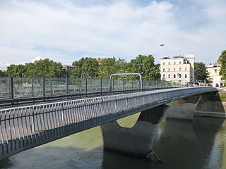
Ponte Pietro Nenni is a bridge crossing the Tiber in Rome, which connects lungotevere Arnaldo da Brescia and lungotevere Michelangelo, in the Quarter Flaminio and Rione Prati respectively.

References

  1. Rendina (2005), p. 685
  2. 1 2 3 "Roma, Ponte della Magliana allarme della Sapienza "Rischio crollo: va chiuso"". Repubblica.it (in Italian). 21 January 2018. Retrieved 28 March 2019.
  3. Rome bridge risks collapsing
  4. "Roma Capitale, Viadotto Magliana: "Lavori sicurezza e segnaletica. Commissionato studio sullo stato strutture"". FreedomPress. 2 August 2018. Retrieved 28 March 2019.

Sources

Coordinates: 41°50′21.76″N12°27′28.54″E / 41.8393778°N 12.4579278°E / 41.8393778; 12.4579278