Ostiense

Last updated
Ostiense
Quartiere of Rome
Piazzale Ostiense Piramide porta san Paolo.jpg
Piazzale Ostiense, with the Piramide Cestia and Porta San Paolo
Ostiense.png
Position of the quartiere within the city
CountryFlag of Italy.svg  Italy
Region Lazio
Province Rome
Comune Rome
Area
  Land2.7502 sq mi (7.1231 km2)
Population
 (2016) [1]
  Total62,339
  Density22,666.7/sq mi (8,751.67/km2)
Time zone UTC+1 (CET)
  Summer (DST) UTC+2 (CEST)
Giuseppe Vasi 18th century etching of Porta Ostiensis (now called Porta San Paolo) in the original city walls of Rome, and the Pyramid of Cestius to the left. Porta S. Paolo - Plate 011 - Giuseppe Vasi.jpg
Giuseppe Vasi 18th century etching of Porta Ostiensis (now called Porta San Paolo) in the original city walls of Rome, and the Pyramid of Cestius to the left.
Porta Ostiensis today, the location of Ostiense Museum. Roma-Porta San Paolo.JPG
Porta Ostiensis today, the location of Ostiense Museum.

Ostiense is the 10th quartiere of Rome, identified by the initials Q. X.

Contents

The toponym comes from the original name of the Porta San Paolo, a gate in the city walls of Rome, was Porta Ostiensis, because it was located at the beginning of Via Ostiense. It now houses the Via Ostiense Museum.

History

In the late 9th century, a fortified settlement developed around the Basilica of Saint Paul Outside the Walls: the village took the name of Giovannipoli after Pope John VIII, who built it for defense purposes after a Saracen raid.

Ostiense is amongst the first 15 quartieri that sprung in 1911 and were officially established in 1921. It began to sprawl in 1907, after the mayor Ernesto Nathan promoted the creation of an industrial area [2] at the beginning of the Via Ostiense; then, after the 1909 town plan was approved, a fluvial harbour, the Mercati Generali, a prominent gasometer and the Centrale Montemartini (a former power station now housing part of the Capitoline Museum's collection of classical sculpture) were built.

The landmarks in the quarter include the Centrale Montemartini and the Basilica of Saint Paul Outside the Walls. [3]

Other landmarks include the Roma Ostiense railway station and most of the University of Rome III campus.

The railway station is home to the Italian railway company Nuovo Trasporto Viaggiatori. It is the city's main hub and home to Italian food market chain Eataly, world's biggest store.

Geography

The quartiere is positioned in the south metropolitan area of Rome, [4] close to the left bank of the Tiber.

It comprises the area near the Via Ostiense from the Porta San Paolo to the Magliana Viaduct. The neighborhood of Garbatella is comprised within its official borders. [ citation needed ]

The territory of the quarter includes the urban zone 11AOstiense of the Municipio VIII.

Boundaries

The quartiere borders, to the north, with Rione Testaccio (R. XX), from which is separated by the stretch of the Aurelian Walls between the river Tiber and Porta San Paolo, and with Rione San Saba (R. XXI), from which is separated by the stretch of the Aurelian Walls between the said Porta San Paolo and Porta Ardeatina.

Eastward, the quartiere shares a border with Quartiere Ardeatino (Q. XX), whose boundary is outlined by a portion of Via Cristoforo Colombo, between Via di Porta Ardeatina and Via Laurentina, and by a stretch of Via Laurentina itself, between Via Cristoforo Colombo and Via delle Tre Fontane.

Southward, Ostiense borders with Quartiere Europa (Q. XXXII), from which is separated by Via delle Tre Fontane and by the Magliana Viaduct.

To the west, Ostiense borders with Quartiere Portuense (Q. XI), the border being marked by the stretch of the Tiber between the Magliana Viaduct and Ponte dell'Industria.

Local geography

The main roads and squares of Quartiere Ostiense are:

The squares and the roads of the quartiere are chiefly named after explorers and missionaries. Local toponyms can be categorized as follows:

Places of interest

Churches

Archaeological sites

Museums

Related Research Articles

<span class="mw-page-title-main">Trastevere</span> Rione of Rome in Lazio, Italy

Trastevere is the 13th rione of Rome: it is identified by the initials R. XIII and it is located within Municipio I. Its name comes from Latin trans Tiberim, literally 'beyond the Tiber'.

<span class="mw-page-title-main">Aurelian Walls</span> Defensive fortifications built around Rome in the 3rd century AD

The Aurelian Walls are a line of city walls built between 271 AD and 275 AD in Rome, Italy, during the reign of the Roman Emperor Aurelian. They superseded the earlier Servian Wall built during the 4th century BC.
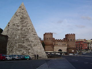
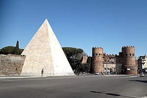
<span class="mw-page-title-main">Testaccio</span> Rione of Rome in Lazio, Italy

Testaccio is the 20th rione of Rome, identified by the initials R. XX, deriving its name from Monte Testaccio. It is located within the Municipio I.

<span class="mw-page-title-main">Prati</span> Rione of Rome in Lazio, Italy

Prati is the 22nd rione of Rome, identified by the initials R. XXII. It belongs to the Municipio I since 2013, while previously, along with Borgo and quartieri Trionfale and Della Vittoria, it was part of the Municipio XVII.
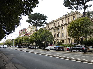
<span class="mw-page-title-main">Campo Marzio</span> Rione of Rome in Lazio, Italy

Campo Marzio is the 4th rione of Rome, identified by the initials R. IV. It belongs to the Municipio I and covers a smaller section of the area of the ancient Campus Martius. The logo of this rione is a silver crescent on a blue background.

<span class="mw-page-title-main">Porta San Paolo</span> Gate of the Aurelian walls, a landmark of Rome, Italy

The Porta San Paolo is one of the southern gates in the 3rd-century Aurelian Walls of Rome, Italy. The Via Ostiense Museum is housed within the gatehouse. It is in the Ostiense quarter; just to the west is the Roman Pyramid of Cestius, an Egyptian-style pyramid, and beyond that is the Protestant Cemetery.

The Via Laurentina is the name born by an ancient and a modern road of Italy, both leading southwards from Rome.

<span class="mw-page-title-main">Piramide (Rome Metro)</span> Rome metro station

Piramide is a station on Line B of the Rome Metro. It was opened on 10 February 1955 and is sited on Piazzale Ostiense just outside Porta San Paolo, in the Ostiense quarter. Its atrium houses mosaics that have won the Artemetro Roma by Enrico Castellani (Italy) and Beverly Pepper. The station has escalators.

<span class="mw-page-title-main">Basilica San Paolo (Rome Metro)</span> Rome metro station

Basilica San Paolo is a station on the Line B of the Rome Metro. It was opened in 1955 and is located at the intersection between Viale Giustiniano Imperatore and Via Gaspare Gozzi, behind the Basilica of Saint Paul Outside the Walls in the Ostiense quarter. It is also one of three Metro stations also served by the Rome-Lido railway line.

<span class="mw-page-title-main">Roma Porta San Paolo railway station</span>

Roma Porta San Paolo is the terminal train station of the Rome–Lido railway line in Rome (Italy). The station is connected to the station Piramide of the metro and to the Roma Ostiense railway station of the Ferrovie dello Stato Italiane. It has six tracks.

<span class="mw-page-title-main">Via Cristoforo Colombo</span>

Via Cristoforo Colombo is a street in Rome (Italy) that links the historic centre to Ostia. Along most of its route, the street has three lanes for each direction of movement. With its 27 kilometres (17 mi) length it is the longest Italian road among those included within the borders of a single municipality and, in several stretches, the largest in Italy.

<span class="mw-page-title-main">ATAC SpA</span> Public Transport Society in Rome

ATAC S.p.A. is an Italian publicly owned company running most of the local public transportation services, paid parking and incentive parking lots in Rome. More specifically, the company handles, on behalf of Roma Capitale Authority, the entire tramway, trolleybus network and metro lines, as well as most of the bus lines in the city. It also operates, on behalf of the Administrative Region of Lazio, three railways: Roma-Civita Castellana-Viterbo, Roma-Giardinetti and Roma-Lido. ATAC S.p.A., with its 2,200-kilometer-wide public transport network, its over 8,500 busses and 70,000 parking stalls, is currently one of the biggest public transportation companies in Europe and the largest in Italy.

<span class="mw-page-title-main">Lungotevere</span> Boulevard in Rome, Italy

Lungotevere is an alley or boulevard running along the river Tiber within the city of Rome. The building of the Lungoteveres required the demolition of the former edifices along the river banks and the construction of retaining walls called muraglioni.

<span class="mw-page-title-main">Portuense</span> Quartiere of Rome in Lazio, Italy

Portuense is the 11th quartiere of Rome (Italy), identified by the initials Q.XI.

<span class="mw-page-title-main">Ponte della Magliana</span> Bridge in Q.X Ostiense and Q.IX Portuense, Italy

Ponte della Magliana is a motorway bridge in Rome (Italy). It crosses the Tiber between Pian due Torri and Via del Cappellaccio, linking the Quartieri Portuense and Ostiense, respectively on the right and on the left of the river.
It is currently part of a larger viaduct, which continues on the right bank of the Tiber towards the Colli Portuensi urban zone and the highway to the Fiumicino Airport and on the left one towards the EUR district, the Tre Fontane urban zone and Via Laurentina.

<span class="mw-page-title-main">Pinciano</span> Quartiere of Rome in Lazio, Italy

Pinciano is the 3rd quartiere of Rome (Italy), identified by the initials Q. III. The name derives from the Pincian Hill. It belongs to the Municipio II.

<span class="mw-page-title-main">Prenestino-Labicano</span> Quartiere of Rome in Lazio, Italy

Prenestino-Labicano is the 7th quartiere of Rome (Italy), identified by the initials Q. VII. The name derives from the ancient roads Via Prenestina and Via Labicana, today the initial stretch of Via Casilina. It belongs to the Municipio V and Municipio VII.

<span class="mw-page-title-main">Gianicolense</span> Quartiere of Rome in Lazio, Italy

Gianicolense[dʒanikoˈlɛnse] is the 12th quartiere of Rome (Italy), identified by the initials Q. XII. It belongs to the Municipio XI and Municipio XII. It takes its name from the Janiculum hill, which lies in the nearby rione Trastevere and whose western extremities correspond to the area of Monteverde.

<span class="mw-page-title-main">Trionfale</span> Quartiere of Rome in Lazio, Italy

Trionfale is the 14th quartiere of Rome (Italy), identified by the initials Q. XIV. The toponym also indicates the urban zone 19E of Municipio XIV.

<span class="mw-page-title-main">Ardeatino</span> Quartiere of Rome in Lazio, Italy

Ardeatino is the 20th quartiere of Rome (Italy), identified by the initials Q. XX. It belongs to the Municipio I and VIII.

References

  1. Roma Capitale – Roma Statistica. Population inscribed in the resident register at 31 December 2016 by toponymy subdivision.
  2. "Ostiense, San Paolo & Garbatella in Rome, Italy".
  3. "7 Reasons You Should Visit the Ostiense Neighborhood".
  4. Ostiense, Rome, Lazio, TripAdvisor.

Coordinates: 41°51′49″N12°28′44″E / 41.863651°N 12.478911°E / 41.863651; 12.478911