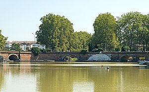
In fact, there are three bridges, each of which is the entrance to a canal. The entrance to the Canal du Midi is in the center. The Canal de Garonne to the north. The Canal de Brienne to the south. The north bridge was added during construction of the Canal de Garonne in 1844.
For boats to turn from one canal into another, the close quarters usually require them to proceed into the basin and turn before going into the next canal.[1] The basin contains the Port de l'Embouchure.
History
The ancient economic dream of connecting the Mediterranean Sea to the Atlantic Ocean by waterway in order to avoid the obligatory passage of goods through the Strait of Gibraltar was realized in the 17th century by the Languedoc States on behalf of which Pierre-Paul Riquet excavated the Midi Canal from Sète to Toulouse. The Midi Canal's waters, via the descent lock of the port de l'Embouchure, which began construction in 1670, joins the Garonne on which traffic continues until Bordeaux.[2][3][4]
A first bridge crossed the port at the outlet of the canal, the Petit Gragnague bridge. Because of the obstacle presented by the Bazacle, the canal could not reach the river Garonne until well downstream of the waterway, north of Toulouse, and the boats which sailed on the Garonne upstream, likewise, could not reach the canal. Similarly, the boats that circulated on the canal could not reach the ports of Garaud, the Port de la Daurade, Port Viguerie, or Saint-Pierre in the center of Toulouse.[2][3][4]
To get around the obstacle, the archbishop of Toulouse, Étienne-Charles de Loménie de Brienne, as president of the Languedoc States, financed, nearly a hundred years later, the excavation of a canal, which he entrusted to Joseph-Marie de Saget, a civil engineer from the province of Languedoc. Commissioned in 1776, the Canal de Brienne crossed the Bazacle near the port de l'Embouchure, permitting the continuity of the navigation upstream of the waterway.[2][3][4]
Jonction du Canal du Midi ou de Languedoc, et du Canal de Brienne à 1/4 de lieue au nord de Toulouse le 21 août 1818, (Junction of the Canal du Midi or de Languedoc, and the Canal de Brienne at a 1/4 of a league north of Toulouse on August 21, 1818), ink drawing, Ancely collection of the Library of Toulouse
The port de l'Embouchure was widened at the confluence of the two canals. The construction of the two bridges at the junction of the two mouths was necessary. The span of the Petit Gragnague bridge, which previously crossed only the Canal du Midi, was too short due to the excavation of the Brienne canal, and was demolished and replaced by two identical bridges, the Ponts-Jumeaux. Each span of the Ponts-Jumeaux includes an archen anse de panier (in basket handle, a type of elliptical three-point curve) with a keystone and bandeau (bandage, in French architecture) in stone as the support of the parapet, the cornice and the external arch of the vaults. Their construction was also entrusted to Joseph-Marie Saget. The first was completed in 1771, the second in 1774. The space between the two was decorated in 1775 with an allegorical bas-relief carved in Carrara marble by François Lucas, professor at the Royal Academy. All were inaugurated in 1776.[2][3][4]
The irregular course of the Garonne, with variable flows and violent floods, required the construction of a new canal to reach Bordeaux. The decision was made in 1838, and the construction of the lateral canal to the Garonne was entrusted to the divisional inspector of bridges and causeways, Jean-Baptiste de Baudre. Beginning in 1857, it connected Toulouse to Castets-en-Dorthe and ensured the junction from the port de l'Embouchure with the Canal du Midi, together taking the name of Canal des Deux-Mers. A third bridge was built over the third canal, connecting to the other two and giving the port, once again enlarged on this occasion, the shape of a hemicycle. A work of art and civil engineering, it was enhanced by the bas-relief of the sculptor François Lucas. The ensemble of Ponts-Jumeaux, now three bridges, constitutes a beautiful classic composition and a major work of river heritage.[2][3][4][5]
On May 7, 1906, the AE line of the Ancien tramway de Toulouse connected the rue Lafayette to the Ponts-Jumeaux.
At the end of the 1970s, the lock and the mouth on the Garonne disappeared with the development of the Toulouse ring road and the construction of the Ponts-Jumeaux interchange. The basin was closed on the river side. The waters of the port that always joined the Garonne by the old lock are now buried at the right of the ring road bridge.[2][3]
Bas relief
A bas-relief is presented between the bridges south side by the Toulouse artist Francois Lucas in 1775 in Carrara marble.[1]
"The allegorical sculpture depicts Occitania in the center holding the rudder of a boat decorated with the Languedoc cross. She orders two cherub laborers to dig the canal for the 'convenience and security of her commerce'. The Canal is personified by a bearded man, his left arm leaning on an urn. The cherub laborers are placed in front of a lock behind which looms a boat sail. Between the sail and the central wall, we can see a panorama of Toulouse on which one can see the dome of the Carthusians. On the right the Garonne, holding a cornucopia, a cherub laborer holding a plow encourages oxen with his hand. Occitania represents the States of Languedoc, funding the project. The action of the Province allows prosperity and fertility to come to the city of Toulouse, personified by the Garonne."[4]
The Garonne is a river that flows in southwest France and northern Spain. It flows from the central Spanish Pyrenees to the Gironde estuary at the French port of Bordeaux – a length of 529 km (329 mi), of which 47 km (29 mi) is in Spain ; the total length extends to 602 km (374 mi) if one includes the Gironde estuary between the river and the sea. Its basin area is 56,000 km2 (22,000 sq mi), which increases to 84,811 km2 (32,746 sq mi) if the Dordogne River, which flows from the east and joins the Garonne at Bec d'Ambès to form the Gironde estuary, is included.
Toulouse is the prefecture of the French department of Haute-Garonne and of the larger region of Occitania. The city is on the banks of the River Garonne, 150 kilometres from the Mediterranean Sea, 230 km (143 mi) from the Atlantic Ocean and 680 km (420 mi) from Paris. It is the fourth-largest city in France after Paris, Marseille and Lyon, with 504,078 inhabitants within its municipal boundaries (2021); its metropolitan area has a population of 1.5 million inhabitants (2021). Toulouse is the central city of one of the 22 metropolitan councils of France. Between the 2014 and 2020 censuses, its metropolitan area was the third fastest growing among metropolitan areas larger than 500,000 inhabitants in France.
The Province of Languedoc is a former province of France. Most of its territory is now contained in the modern-day region of Occitanie in Southern France. Its capital city was Toulouse. It had an area of approximately 42,700 square kilometers.
The Canal du Midi is a 240 km (150 mi) long canal in Southern France. Originally named the Canal Royal en Languedoc and renamed by French revolutionaries to Canal du Midi in 1789, the canal is considered one of the greatest construction works of the 17th century.
Pierre-Paul Riquet, Baron de Bonrepos was the engineer and canal-builder responsible for the construction of the Canal du Midi.
The Tarn is a 380.2-kilometre (236.2 mi) long river in the administrative region of Occitania in southern France. It is a right tributary of the Garonne.
The Canal de Garonne, formerly known as Canal latéral à la Garonne, is a French canal dating from the mid-19th century that connects Toulouse to Castets-en-Dorthe. The remainder of the route to Bordeaux uses the river Garonne. It is the continuation of the Canal du Midi which connects the Mediterranean with Toulouse.
The Canal de Brienne, also known as Canal de Saint-Pierre, is a French canal connecting the Garonne River with the Canal du Midi and the Canal de Garonne. It has two locks. The lock opening to the Garonne is known as Ecluse Saint-Pierre. The lock nearer to the Canal du Midi usually stands open.
Pompertuzat is a commune in the Haute-Garonne department in southwestern France.
There are 91 working locks on the Canal du Midi along its 240-kilometre (150 mi) course from the Bassin du Thau on the Mediterranean coast to the junction with the Canal lateral a la Garonne in Toulouse. There are a further 13 locks on the 37-kilometre (23 mi) La Nouvelle branch which runs through Narbonne to the Mediterranean at Port-la-Nouvelle. The locks are all under the management of the French navigation authority, Voies navigables de France.
The Orb Aqueduct is a bridge which carries the Canal du Midi over the Orb in the city of Béziers in Languedoc, France. The aqueduct is 28 metres (92 ft) wide, 12 metres (39 ft) tall and at 240 metres (790 ft) is the longest on the Canal du Midi.
The Seuil de Naurouze, or Col de Naurouze, is the highest point of the Canal du Midi in southern France. It is the watershed point identified by Pierre-Paul Riquet when he designed and built the canal. Water falling on the western side of this point flows to the Atlantic Ocean and on the eastern side to the Mediterranean Sea. It is on the border of the department of Haute-Garonne and the department of the Aude.
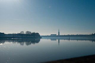
The Port de l'Embouchure is one of the two ports located in Toulouse on the Canal du Midi. The other being the Port Saint-Sauveur. This port is located in the basin at the Ponts Jumeaux. From the basin are found the entrances to the canals Canal de Garonne, Canal du Midi and Canal de Brienne.
The Ecluse Saint-Pierre is one of two locks on the Canal de Brienne. Also known as Garonne lock, in French: Ecluse de Garonne.
The Port de la Daurade is found on the right bank of the Garonne River in Toulouse. Boats leave from here for travel on the Garonne and the Canal du Midi. The Canal de Brienne is near as is the bazacle.
Occitania is the southernmost administrative region of metropolitan France excluding Corsica, created on 1 January 2016 from the former regions of Languedoc-Roussillon and Midi-Pyrénées. The Council of State approved Occitania as the new name of the region on 28 September 2016, coming into effect on 30 September 2016.
The following is a timeline of the history of the city of Toulouse, France.
Louis Charles André Alexandre Du Mège or Dumège,, was a French scholar, archaeologist and historian.
The Society of Moulins du Bazacle, also known as Bazacle Company is a French watermill system founded in Toulouse in the 12th century by the citizens of the city to share the operation of a series of mills installed on the site of the Bazacle. The mills were used to process wheat harvested from the Toulouse Plain into flour.
Compans-Caffarelli is a business district in Toulouse in Haute-Garonne, France, where companies and grandes écoles are located.
Wikimedia Commons has media related to Ponts-Jumeaux.
Wikimedia Commons has media related to Canal du Midi.
This page is based on this Wikipedia article Text is available under the CC BY-SA 4.0 license; additional terms may apply. Images, videos and audio are available under their respective licenses.


 Une visite au sculpteur (1896), Édouard Debat-Ponsan, Capitole de Toulouse
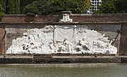 The bas-relief of François Lucas.