Poor Valley Creek State Park

Last updated

Poor Valley Creek State Park
Poor Valley Park
Poor Valley Creek State Park Map TVA.jpg
A map of the proposed park by the Tennessee Valley Authority
Poor Valley Creek State Park
Type State park
Location Hawkins County, Tennessee, United States
Nearest town Bean Station, Tennessee
Coordinates 36°21′20″N83°12′46″W / 36.355468°N 83.212907°W / 36.355468; -83.212907
Area1,903 acres (7.70 km2)
Operated by Tennessee Department of Environment and Conservation, Tennessee Valley Authority
Visitors218,000(in 1968 estimate) [1]
StatusShelved

Poor Valley Creek State Park was a proposed state park in western Hawkins County, Tennessee, United States. It would have been located prominently near the Poor Valley Creek embayment of Cherokee Lake, an impoundment of the Holston River. The park was first planned in 1945, and shelved indefinitely following comments supporting "no action" on the project by state agencies in 1976. [2]

Contents

History

The origins of plans for a park in the Poor Valley region were first discussed around 1945, when Winfield Hale, the judge of Hawkins County and president of the county's chamber of commerce, suggested the idea of a public recreation area to G.L. Arsdall, who was the acting manager for the Tennessee Valley Authority (TVA) firm Norris-Cherokee Properties, which maintained land owned by the TVA obtained for the Cherokee and Norris hydroelectricity projects. Hale would continue suggesting the need for a state park in the Poor Valley vicinity when in 1949, he was contacted by James Pope, director of the TVA. Hale would learn that the TVA since 1941, had been planning the development of a public recreation area in the Poor Valley region and work for a lateral dam on the Poor Valley Creek embayment of Cherokee Lake was underway. The next year, Hale would head to Washington, D.C. for meetings with U.S. Senators Albert Gore, Sr. and Estes Kefauver supporting funding and efforts for a state park in Hawkins County. [3]

In 1957, officials from the office of then Governor Frank Clement, and the Tennessee Department of Environment and Conservation (TDEC), which operates the Tennessee State Parks system, would begin discussions with Hawkins County leaders including state representative Omar Robinson of Rogersville, [4] and start initial surveying and studies on-site for the Poor Valley State Creek Park project. [5] In the following year, the Tennessee Wildlife Resources Agency (TWRA) would report that the Poor Valley site would be most suitable as a state park rather than a hunting preserve or nature refuge. [3]

Throughout the 1960s, the park project would go through more studies and grant-writing when a major win for the park occurred in 1963, James Quillen would be elected as a congressman serving Tennessee's 1st congressional district, which represented Hawkins County. The Kingsport native would support the proposals for the park and federal funding for the TVA to construct the dam on Poor Valley Creek required to maintain it at a full capacity annually. [3]

By the 1970s, the final planning and development work of the project would start, as the Tennessee General Assembly would vote to appropriate $50,000 in 1971 to the TDEC for initial operations of the park, equivalent to $361,298in 2022. Investigations by the Kingsport Times-News would discover that this funding would never be spent by the TDEC. [3] In May 1973, the TVA would sign an agreement with the Tennessee state government to complete the project, having the TVA pay 80% for the construction of the lateral dam, and transfer the land and water to the state at no cost while the state would support the cost and most oversight regarding the development of the park. [6] In 1975, the TVA would complete its environmental impact statement (EIS) for the park and the dam. [7] Around this time, the federal funding proposed by Congressman Quillen for the TVA to construct the dam would be deleted for the reportedly third time by the Office of Management and Budget (OMB) before the funding bill for TVA-related projects reached the United States Congress. [3]

After the publication of the impact statement by the TVA, and influenced by both the completion of the nearby Panther Creek State Park in Hamblen County, and the deletion of dam construction funding by the OMB, the project would receive non-favorable feedback from the previously-supportive TDEC and TWRA, which both recommended in reaction the TVA’s EIS that "no action" be taken to complete and develop Poor Valley Creek State Park. With the loss of the necessary federal funding and unfavorable comments from the TDEC and TWRA, the project would be shelved indefinitely, with no action having been taken on the project since 1976. [2] In 1987, portions of Short Mountain would be developed into a silica mining facility near the park site despite local controversy and opposition by residents, supporters of the state park project, and local and state government officials. [8]

Geographical setting

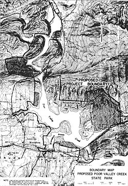
The proposed park would have been located on 1,903 acres surrounding the Poor Valley Creek watershed of Cherokee Lake in unincorporated Hawkins County near the community of Mooresburg. 1,468 of the 1,903 acres for the park would be protected forest under the ownership of the TVA, while the remaining 435 acres which consisted of privately-owned agricultural land. [7]

The Poor Valley Creek watershed is surrounded by forested shale-based mountain slopes in the Ridge-and-Valley Appalachians province, the highest being Short Mountain at 2,651 feet. [7]

Ecology

The Poor Valley Creek site was analyzed for ecological purposes in the TVA's EIS published in 1975. It was found to support a diverse array of vegetation and wildlife. In the site, most of the vegetation had existed prior to the impoundment of the creek by the TVA for the Cherokee Project. Over 36 species of trees were identified in the site, with most being cove, mixed, and upland hardwoods, and mixed pine. [7]

On-site studies performed by the TVA revealed the prominence of bass, bluegill, shiner, crappie, darter, and carp fish species in upstream Poor Valley Creek and the embayment near Cherokee Lake. Birds known to have the site as a habitat include sandpiper, warbler, hawk, woodpecker, sparrow, and duck species. Mammal species spotted included opossum, skunk, squirrel, fox, raccoon, and deer. Amphibians and reptiles spotted included frog, turtle, snake, and salamander species. [7]

Recreation and facilities

The exact amenities and facilities that would have been offered at Poor Valley Creek State Park is unknown, but the state would agree to the construction and development of several recreational facilities following the 1973 agreement with the TVA. In the agreement, the state government would develop a marina, group lodge, an environmental interpretation center, lighted tennis courts and athletic ball-fields, hiking and mountain biking trails, horse stables, a trading post/concession center, and over 50 fully-facilitated campsites and picnic areas. [6]

A linear dam constructed by the TVA south of the site and the U.S. Route 11W bridges on the creek would have made the creek into a 543 acre reservoir fit for the proposed water-based amenities for the park. [6]

Proposals once part of the park plan but were never used in the final plans included an 18-hole golf course, a hunting preserve, and an expanded hiking trail system on an extra 4,000 acres around Short Mountain. [2] [4]

Related Research Articles

<span class="mw-page-title-main">Grainger County, Tennessee</span> County in Tennessee, United States

Grainger County is a county located in the U.S. state of Tennessee. As of the 2020 census, the population was 23,527. Its county seat is Rutledge. Grainger County is a part of both the Knoxville Metropolitan Statistical Area and Morristown Metropolitan Statistical Area.

The Big Sandy River is a 60-mile-long (97 km) tributary of the Tennessee River in the U.S. state of Tennessee. Via the Tennessee and Ohio rivers, it is part of the Mississippi River watershed. The Big Sandy rises about 5 miles (8 km) northwest of Lexington, in the same vicinity as two other important rivers of West Tennessee, the Beech River and the Middle Fork of the Forked Deer River.

<span class="mw-page-title-main">Norris Dam</span> Dam in Tennessee, United States

Norris Dam is a hydroelectric and flood control structure located on the Clinch River in Anderson County and Campbell County, Tennessee, United States. The dam was the first major project for the Tennessee Valley Authority, which had been created in 1933 to bring economic development to the region and control the rampant flooding that had long plagued the Tennessee Valley. The dam was named in honor of Nebraska Senator George Norris (1861–1944), a longtime supporter of government-owned utilities in general, and supporter of TVA in particular. The infrastructure project was listed on the National Register of Historic Places in 2016.

<span class="mw-page-title-main">Tellico Dam</span> Dam in Tennessee, United States

Tellico Dam is a concrete gravity and earthen embankment dam on the Little Tennessee River that was built by the Tennessee Valley Authority (TVA) in Loudon County, Tennessee. Planning for a dam structure on the Little Tennessee was reported as early as 1936 but was deferred for development until 1942. Completed in 1979, the dam created the Tellico Reservoir and is the last dam to be built by the Tennessee Valley Authority.

<span class="mw-page-title-main">Bean Station, Tennessee</span> Lakeside town in Grainger and Hawkins counties, Tennessee

Bean Station is a town in Grainger and Hawkins counties in the state of Tennessee, United States. As of the 2020 census, the population was 2,967. It is part of the Kingsport Metropolitan Statistical Area, Knoxville Metropolitan Statistical Area, and Morristown metropolitan statistical area. Established in 1776 as a frontier outpost by pioneer William Bean, it is considered one of the earliest permanently settled communities in Tennessee. It grew throughout the rest of the 18th and 19th centuries as an important stopover for early pioneers and settlers in the Appalachia region due to its strategic location at the crossroads of Daniel Boone's Wilderness Road and the Great Indian Warpath.

<span class="mw-page-title-main">Fontana Dam</span> Dam in North Carolina, United States

Fontana Dam is a hydroelectric dam on the Little Tennessee River in Swain and Graham counties, North Carolina, United States. The dam is operated by the Tennessee Valley Authority, which built the dam in the early 1940s to satisfy the skyrocketing electricity demands in the Tennessee Valley to support the aluminum industry at the height of World War II; it also provided electricity to a formerly rural area.

<span class="mw-page-title-main">Guntersville Dam</span> Dam in Alabama, United States

Guntersville Dam is a hydroelectric dam on the Tennessee River in Marshall County, in the U.S. state of Alabama. It is one of nine dams on the river owned and operated by the Tennessee Valley Authority, which built the dam in the late 1930s as part of a New Deal era initiative to create a continuous navigation channel on the entire length of the river and bring flood control and economic development to the region. The dam impounds the Guntersville Lake of 67,900 acres (27,500 ha), and its tailwaters feed into Wheeler Lake.

<span class="mw-page-title-main">U.S. Route 11W</span> Suffixed section of U.S. Highway in Tennessee and Virginia in the United States

U.S. Route 11W (US 11W) is the western branch of US 11 from the twin cities of Bristol, Tennessee/Bristol, Virginia, where US 11 splits into US 11E and US 11W, to Knoxville, Tennessee, where the two highways rejoin. The highway serves the Appalachia region's Ridge-and-Valley section of East Tennessee, bounded by the Clinch Mountain ridge to the north and the Holston River to the south. US 11W from Bristol to Bean Station and Blaine to Knoxville are designated as part of the National Highway System.

<span class="mw-page-title-main">Nickajack Dam</span> Dam in Tennessee, United States

Nickajack Dam is a hydroelectric dam in Marion County in the U.S. state of Tennessee. It is one of nine dams on the Tennessee River owned and operated by the Tennessee Valley Authority, which built the dam in the mid-1960s to replace the outdated Hales Bar Dam 6 miles (9.7 km) upstream. The dam impounds the 10,370-acre (4,200 ha) Nickajack Lake and feeds into Guntersville Lake. Nickajack Dam is named for a Cherokee village once located just upstream from the dam. The village was the namesake for Nickajack Cave, which was partially flooded by the reservoir.

<span class="mw-page-title-main">Chickamauga Dam</span> Dam in Tennessee, United States

The Chickamauga Dam is a hydroelectric dam on the Tennessee River in Chattanooga, Tennessee, United States. The dam is owned and operated by the Tennessee Valley Authority, which built the dam in the late 1930s as part of a New Deal era initiative to improve navigation and bring flood control and economic development to the Tennessee Valley. The dam impounds the 36,240-acre (14,670 ha) Chickamauga Lake and feeds into Nickajack Lake. The dam and associated infrastructure were listed on the National Register of Historic Places in 2017.

<span class="mw-page-title-main">Norris Dam State Park</span> United States historic place

Norris Dam State Park is a state park in Anderson County and Campbell County, Tennessee, in the southeastern United States. The park is situated along the shores of Norris Lake, an impoundment of the Clinch River created by the completion of Norris Dam in 1936. The park consists of 4,038 acres (16.34 km2) managed by the Tennessee Department of Environment and Conservation. The park also administers the Lenoir Museum Complex, which interprets the area's aboriginal, pioneer, and early 20th-century history.

<span class="mw-page-title-main">Big Ridge State Park</span> State park in Tennessee, United States

Big Ridge State Park is a state park in Union County, Tennessee, in the southeastern United States. The park consists of 3,687 acres (14.92 km2) on the southern shore of the Norris Reservoir, an impoundment of the Clinch River created by the completion of Norris Dam in 1936. Much of the park's recreational focus is on Big Ridge Lake, a 45-acre (0.18 km2) sub-impoundment of Norris near the center of the park.

<span class="mw-page-title-main">Cherokee Lake</span> Artificial reservoir in East Tennessee, United States

Cherokee Lake, also known as Cherokee Reservoir, is an artificial reservoir in the U.S. state of Tennessee formed by the impoundment of the Holston River behind Cherokee Dam.

<span class="mw-page-title-main">Watauga Dam</span> Dam in Tennessee, United States

Watauga Dam is a hydroelectric and flood control dam on the Watauga River in Carter County, in the U.S. state of Tennessee. It is owned and operated by the Tennessee Valley Authority, which built the dam in the 1940s as part of efforts to control flooding in the Tennessee River watershed. At 318 feet (97 m), Watauga is the second-highest dam in the TVA river and reservoir system, and at the time of its completion was one of the highest earth-and-rock dams in the United States. The dam impounds the TVA Watauga Reservoir of 6,430 acres (2,600 ha), and its tailwaters feed into Wilbur Lake.

<span class="mw-page-title-main">Cherokee Dam</span> Dam in Tennessee, United States

Cherokee Dam is a hydroelectric dam located on the Holston River in Grainger County and Jefferson County, Tennessee, in the southeastern United States. The dam is operated and maintained by the Tennessee Valley Authority, which built the dam in the early 1940s to help meet urgent demands for energy at the outbreak of World War II. Cherokee Dam is 175 feet (53 m) high and impounds the 28,780-acre (11,650 ha) Cherokee Lake. It has a generating capacity of 136 megawatts. The dam was named for the Cherokee, a Native American tribe that controlled much of East Tennessee when the first European settlers arrived in the mid-18th century.

<span class="mw-page-title-main">South Holston Dam</span> Dam in Tennessee, United States

South Holston Dam is a hydroelectric and flood control dam on the South Fork Holston River in Sullivan County, in the U.S. state of Tennessee. It is the uppermost of three dams on the South Fork Holston owned and operated by the Tennessee Valley Authority, which built the dam in the 1940s as part of efforts to control flooding in the Tennessee River watershed. On October 21, 1950 the valve gate closed and water began backing up to create South Holston Reservoir. Work began on the dam in December 1941, but in November 1942, the War Production Board requested that the operation be suspended because of a shortage of critical materials. Work did not resume until July 1, 1947. The dam now impounds the South Holston Lake of 7,550 acres (3,060 ha), which extends northeastward across the Tennessee-Virginia state line.

<span class="mw-page-title-main">Fort Patrick Henry Dam</span> Dam in Tennessee, United States

Fort Patrick Henry Dam is a hydroelectric dam on the South Fork Holston River within the city of Kingsport, in Sullivan County in the U.S. state of Tennessee. It is the lowermost of three dams on the South Fork Holston owned and operated by the Tennessee Valley Authority, which built the dam in the early 1950s to take advantage of the hydroelectric potential created by the regulation of river flow with the completion of Watauga Dam, South Holston Dam, and Boone Dam further upstream in preceding years. The dam impounds the 872-acre (353 ha) Fort Patrick Henry Lake. While originally built for hydroelectric generation, the dam now plays an important role in the regulation of water flow and water temperature for the John Sevier Fossil Plant and other industrial plants downstream. The dam and associated infrastructure were listed on the National Register of Historic Places in 2017.

<span class="mw-page-title-main">Mooresburg, Tennessee</span> CDP in Tennessee, United States

Mooresburg is a census-designated place (CDP) and an unincorporated town in Hawkins County, Tennessee. Its population was 941 as of the 2010 census. It is located along U.S. Route 11W between Rogersville and Bean Station.

<span class="mw-page-title-main">Phipps Bend Nuclear Plant</span> Uncompleted nuclear power plant in Hawkins County, Tennessee

Phipps Bend Nuclear Plant was a planned nuclear power generation facility that was to be constructed and operated by the Tennessee Valley Authority (TVA) in unincorporated Hawkins County, Tennessee. Proposed to house two reactor units, the power plant was estimated to cost $1.6 billion when it was first planned in late 1977, provide a generating capacity of 2,600,000 kilowatts. Following negative public reactions towards nuclear energy following the Three Mile Island accident and a decreasing demand for power due to regional economic decline, the TVA's board of directors voted to defer further construction of the power plant. By 1981, the plant was 40% complete and an estimated $1.5 billion in planning, engineering, and construction costs had accumulated. Construction never resumed, and the project was canceled overall in 1982 due to lower load growth than forecast. By the project's cancellation, the TVA had amassed over $2.6 billion in spending for the incomplete nuclear facility. After being auctioned off by the TVA in 1987, the land acquired for the plant would be under the ownership of Hawkins County's industrial development board, who converted most of the site into an industrial park. A 1 MW solar farm was built at the site in 2017.

<span class="mw-page-title-main">Cherokee Removal Memorial Park</span> Memorial park in Tennessee, United States

Cherokee Removal Memorial Park is a public park in Meigs County, Tennessee that is dedicated in memory of the Cherokee who were forced to emigrate from their ancestral lands during the Cherokee removal, in an event that came to be known as the Trail of Tears. It was established in 2005, and has since expanded.

References

  1. U.S. Economic Development Administration (1968). Poor Valley Creek: A Study of Development Alternatives. Wolf Management Services. Retrieved May 15, 2021.
  2. 1 2 3 Ripley, Pam (March 10, 1976). "The Poor Valley Park Plan - Who's Holding It Back". Kingsport Times-News . p. 1D. Retrieved May 15, 2021 via Newspapers.com.
  3. 1 2 3 4 5 Johnston, Sheila (October 27, 1976). "Poor Valley Park: The Wait Goes On". Kingsport Times-News . p. 1, 8 . Retrieved May 15, 2021 via Newspapers.com.
  4. 1 2 Hodge, Tom (March 31, 1957). "Poor Valley State Park Proposed For E-T Area". Johnson City Press. p. 1, 1A . Retrieved May 15, 2021 via Newspapers.com.
  5. "Natural Beauty Of ET Beckons To Another Park". The Knoxville Journal. May 12, 1957. p. 1D. Retrieved May 15, 2021 via Newspapers.com.
  6. 1 2 3 "30 Years Of Planning Pays Off In Hawkins Park Site". Kingsport Times-News . May 13, 1973. p. 8A. Retrieved May 15, 2021 via Newspapers.com.
  7. 1 2 3 4 5 Poor Valley Creek State Park: Environmental Impact Statement. Tennessee Valley Authority. 1975. Retrieved May 14, 2021.
  8. Now and Then : Hawkins County, Tennessee. Brice & Caldwell. 1995. pp. 56–57.

Further reading