Mooresburg | |
|---|---|
 | |
 Mooresburg  Mooresburg | |
| Coordinates: 36°20′47″N83°13′42″W / 36.34639°N 83.22833°W | |
| Country | United States |
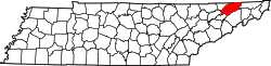
| State | Tennessee |
| Counties | Hawkins |
| Settled | 1800 [1] |
| Area | |
• Total | 4.23 sq mi (10.95 km2) |
| • Land | 3.79 sq mi (9.81 km2) |
| • Water | 0.44 sq mi (1.15 km2) |
| Elevation | 1,089 ft (332 m) |
| Population | |
• Total | 877 |
| • Density | 231.6/sq mi (89.44/km2) |
| Time zone | UTC-5 (Eastern (EST)) |
| • Summer (DST) | UTC-4 (EDT) |
| ZIP code | 37811 |
| Area code | 423 |
| GNIS feature ID | 1294319 [4] |
| Website | mooresburg |
Mooresburg is a census-designated place (CDP) and an unincorporated town [1] in Hawkins County, Tennessee. Its population was 941 as of the 2010 census. [5] It is located along U.S. Route 11W between Rogersville and Bean Station.