Mount Carmel, Tennessee

Last updated

Mount Carmel
Mount-Carmel-welcome-sign-tn1.jpg
Town (City) of Mount Carmel sign along Main Street
City of Mount Carmel, TN Seal.png
Hawkins County Tennessee Incorporated and Unincorporated areas Mount Carmel Highlighted 4750580.svg
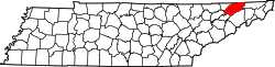
Location in Hawkins County, Tennessee
Coordinates: 36°33′56″N82°39′12″W / 36.56556°N 82.65333°W / 36.56556; -82.65333
Country United States
State Tennessee
County Hawkins
Incorporated1961 [1]
Government
  MayorPat Stillwell
  Town AdministratorEmily Wood
Area
[2]
  Total6.65 sq mi (17.22 km2)
  Land6.64 sq mi (17.21 km2)
  Water0.01 sq mi (0.02 km2)
Elevation
1,365 ft (416 m)
Population
 (2020) [3]
  Total5,473
  Density823.87/sq mi (318.10/km2)
Time zone UTC-5 (Eastern (EST))
  Summer (DST) UTC-4 (EDT)
ZIP code
37645
Area code 423
FIPS code 47-50580 [4]
GNIS feature ID1294565 [5]
Website www.mountcarmeltn.gov

Mount Carmel is a city in Hawkins County, Tennessee, United States. As of the 2010 census, the population was 5,429, [6] an increase of 634 since the 2000 census. It is part of the Kingsport-Bristol-Bristol, TN-VA Metropolitan Statistical Area, which is a component of the "Tri-Cities" region.

Contents

History

Mount Carmel is in Hawkins County, which was once called Spencer county, and was a part of the State of Franklin. The State of Franklin comprised eight counties in western North Carolina in the late 1700s. Governed by John Sevier, it operated as an independent state for four years before it ultimately rejoined North Carolina. [7]

Mount Carmel once garnered national attention in the mid-2000s because of a CBS News story stating the town's geography is situated on only one side of the main highway through the area. Since then, the city has secured property on the other side of the road and has built a cemetery. [8]

Since the 1980s, the community has faced economic hardship due to political turmoil in its government operations, and the outsourcing of its retail and municipal services to neighboring Church Hill and Kingsport. In 2020, the city would begin discussions of connecting to either of the two cities' sewer systems following the Mount Carmel sewer plant going insolvent. Calls for Mount Carmel to merge into Kingsport or Church Hill have been raised since 2021 because of the financial instability. [9]

Geography

Mount Carmel is located in eastern Hawkins County at 36°33′56″N82°39′12″W / 36.56556°N 82.65333°W / 36.56556; -82.65333 (36.565666, -82.653265). [10] It is bordered to the east by the city of Kingsport and to the west by the city of Church Hill. U.S. Route 11W is the main highway through the town, leading east into Kingsport and southwest 22 miles (35 km) to Rogersville, the Hawkins county seat.

According to the United States Census Bureau, Mount Carmel has a total area of 6.9 square miles (18.0 km2), of which 0.01 square miles (0.02 km2), or 0.11%, are water. [6]

Demographics

Historical population
CensusPop.Note
1970 2,821
1980 3,76433.4%
1990 4,0828.4%
2000 4,79517.5%
2010 5,42913.2%
2020 5,4730.8%
Sources: [11] [12] [3]

2020 census

Mount Carmel racial composition [13]
RaceNumberPercentage
White (non-Hispanic)5,18194.66%
Black or African American (non-Hispanic)450.82%
Native American 100.18%
Asian 180.33%
Pacific Islander 10.02%
Other/Mixed 1412.58%
Hispanic or Latino 771.41%

As of the 2020 United States census, there were 5,473 people, 2,184 households, and 1,614 families residing in the town.

2000 census

As of the census [4] of 2000, there were 4,795 people, 1,935 households, and 1,499 families residing in the city. The population density was 701.5 inhabitants per square mile (270.9/km2). There were 2,078 housing units at an average density of 304.0 per square mile (117.4/km2). The racial makeup of the town was 98.27% White, 0.54% African American, 0.13% Native American, 0.15% Asian, 0.04% Pacific Islander, 0.23% from other races, and 0.65% from two or more races. Hispanic or Latino of any race were 0.58% of the population.

There were 1,935 households, out of which 31.9% had children under the age of 18 living with them, 67.1% were married couples living together, 8.2% had a female householder with no husband present, and 22.5% were non-families. 20.3% of all households were made up of individuals, and 8.2% had someone living alone who was 65 years of age or older. The average household size was 2.48 and the average family size was 2.84.

In the city, the population was spread out, with 22.2% under the age of 18, 6.7% from 18 to 24, 30.7% from 25 to 44, 28.4% from 45 to 64, and 12.0% who were 65 years of age or older. The median age was 38 years. For every 100 females, there were 92.6 males. For every 100 females age 18 and over, there were 94.1 males.

The median income for a household in the town was $36,599, and the median income for a family was $43,604. Males had a median income of $34,844 versus $24,340 for females. The per capita income for the city was $16,702. About 5.5% of families and 9.4% of the population were below the poverty line, including 16.0% of those under age 18 and 16.8% of those age 65 or over.

Education

Mount Carmel has one school, Mount Carmel Elementary School, which provides teaching for pre-kindergarten through 4th grade children. The school is part of the Hawkins County School District. [14] Children in fifth and sixth grade attend Church Hill Intermediate School. Seventh and Eighth graders attend Church Hill Middle School. High school students attend Volunteer Comprehensive High School.

Parks and recreation

The Parks and Recreation department is a joint effort between the City of Mount Carmel with fellow Hawkins County cities of Church Hill and Surgoinsville. [15]

Related Research Articles

<span class="mw-page-title-main">Sullivan County, Tennessee</span> County in Tennessee, United States

Sullivan County is a county located in the U.S. state of Tennessee on its northeast border. As of the 2020 census, the population was 158,163. Its county seat is Blountville.

<span class="mw-page-title-main">Hawkins County, Tennessee</span> County in Tennessee, United States

Hawkins County is a county located in the U.S. state of Tennessee. As of the 2020 census, the population was 56,721. Its county seat is Rogersville, Hawkins County is part of the Metropolitan Statistical Area, which is a component of the Johnson City-Kingsport-Bristol, TN-VA Combined Statistical Area, commonly known as the "Tri-Cities" region.

<span class="mw-page-title-main">Laurel Hill, Florida</span> City in Florida, United States

Laurel Hill is a city in Okaloosa County, Florida, United States. The City of Laurel Hill is part of the Fort Walton Beach–Crestview–Destin Metropolitan Statistical Area. The population was 584 at the 2020 US Census.

<span class="mw-page-title-main">Mount Carmel, Illinois</span> City in Illinois, United States

Mount Carmel is a city in and the county seat of Wabash County, Illinois, United States. At the time of the 2010 census, the population was 7,284, and it is the largest city in the county. The next largest town in Wabash County is Allendale, population 475.

<span class="mw-page-title-main">Mount Carmel, Indiana</span> Town in Indiana, United States

Mount Carmel is a town in Springfield Township, Franklin County, Indiana, United States. The population was 86 at the 2010 census.

<span class="mw-page-title-main">Scotland Neck, North Carolina</span> Town in North Carolina, United States

Scotland Neck is a town in Halifax County, North Carolina, United States. According to the 2010 census, the town population was 2,059. It is part of the Roanoke Rapids, North Carolina Micropolitan Statistical Area.

<span class="mw-page-title-main">Middleburg, North Carolina</span> Town in North Carolina, United States

Middleburg is a town in Vance County, North Carolina, United States. The population was 133 at the 2010 census. It was in Warren County and known as Middleburgh prior to the establishment of Vance County in 1881.

<span class="mw-page-title-main">Mount Carmel, Pennsylvania</span> Borough in Pennsylvania, United States

Mount Carmel is a borough in Northumberland County, located in the Coal Heritage Region of Central Pennsylvania's Susquehanna River Valley, United States. The population was 5,725 at the 2020 census. It is located 88 miles (141 km) northwest of Philadelphia and 71 miles (114 km) northeast of Harrisburg, in the Coal Region. It is completely encircled by Mount Carmel Township.

<span class="mw-page-title-main">Baileyton, Tennessee</span> Town in Tennessee, United States

Baileyton is a town in northern Greene County, Tennessee, United States. The population was 431 at the 2010 census, down from 504 at the 2000 census. Baileyton is located 13 miles (21 km) north of Greeneville and 18 miles (29 km) southeast of Rogersville.

<span class="mw-page-title-main">Bulls Gap, Tennessee</span> Town in Tennessee, United States

Bulls Gap is a town in Hawkins County, Tennessee, United States. The population was 756 at the 2020 census. It is part of the Metropolitan Statistical Area, which is a component of the Johnson City-Kingsport-Bristol, TN-VA Combined Statistical Area – commonly known as the "Tri-Cities" region.

<span class="mw-page-title-main">Church Hill, Tennessee</span> City in Tennessee, United States

Church Hill is a city in Hawkins County, Tennessee, United States. The population was 6,998 at the 2020 census and 6,737 at the 2010 census. It is part of the Kingsport-Bristol-Bristol, TN-VA Metropolitan Statistical Area, which is a component of the "Tri-Cities" region. It is the largest municipality located entirely within Hawkins County.

<span class="mw-page-title-main">Rogersville, Tennessee</span> Town in the United States

Rogersville is a town in, and the county seat of, Hawkins County, Tennessee, United States. It was settled in 1775 by the grandparents of Davy Crockett. It is named for its founder, Joseph Rogers. Tennessee's second oldest courthouse, the Hawkins County Courthouse, first newspaper The Knoxville Gazette, and first post office are all located in Rogersville. The Rogersville Historic District is listed on the National Register of Historic Places.

<span class="mw-page-title-main">Surgoinsville, Tennessee</span> Town in Tennessee, United States

Surgoinsville is a town in Hawkins County, Tennessee, United States. The 2020 census showed a population of 1,882, an increase over the figure of 1,801 tabulated in 2010. It is part of the Kingsport–Bristol (TN)–Bristol (VA) Metropolitan Statistical Area, which is a component of the Johnson City–Kingsport–Bristol, TN-VA Combined Statistical Area – commonly known as the "Tri-Cities" region.

<span class="mw-page-title-main">Mount Pleasant, Tennessee</span> City in Tennessee, United States

Mount Pleasant is a city in Maury County, Tennessee, United States. Mount Pleasant was the birthplace of 19th-century writer and humorist Samuel R. Watkins and formerly titled "The Phosphate Capital of the World." The population was 4,561 at the 2010 census, and 4,784 in 2020.

<span class="mw-page-title-main">Blountville, Tennessee</span> CDP in Tennessee, United States

Blountville is a census-designated place (CDP) in and the county seat of Sullivan County, Tennessee. The population was 3,074 at the 2010 census and 3,120 at the 2020 census. It is the only Tennessee county seat not to be an incorporated city or town.

<span class="mw-page-title-main">Nettleton, Mississippi</span> City in Mississippi, United States

Nettleton is a city in Lee and Monroe counties in the U.S. state of Mississippi. The population was 1,935 at the 2020 census. Incorporated in 1888, the town was named after George Henry Nettleton, president of the Kansas City, Memphis and Birmingham Railroad (KCM&B).

<span class="mw-page-title-main">Kingsport, Tennessee</span> City in Tennessee, United States

Kingsport is a city in Sullivan and Hawkins counties in the U.S. state of Tennessee. As of the 2020 census, its population was 55,442. Lying along the Holston River, Kingsport is commonly included in what is known as the Mountain Empire, which spans a portion of southwest Virginia and the mountainous counties in northeastern Tennessee. It is the largest city in the Kingsport–Bristol metropolitan area, which had a population of 307,614 in 2020. The metro area is a component of the larger Tri-Cities region of Tennessee and Virginia, with a population of 508,260 in 2020.

<span class="mw-page-title-main">St. Paul, Virginia</span> Town in Virginia, United States

St. Paul is a town in Russell and Wise counties in the U.S. state of Virginia. The population was 970 at the 2010 census. Virginia City Hybrid Energy Center, which powers 150,000 homes, is located in St. Paul.

The Kingsport–Bristol–Bristol metropolitan area is a metropolitan statistical area (MSA) in Northeast Tennessee and Southwest Virginia, United States, as defined by the Office of Management and Budget (OMB). It was formed in December 2003 by the merger of the Bristol, VA MSA and Kingsport–Bristol, TN–VA MSA.

The Johnson City Metropolitan Statistical Area, as defined by the United States Census Bureau, is an area consisting of three counties in East Tennessee, anchored by the city of Johnson City. As of the 2020 census, the MSA had a population of 207,285.

References

  1. Sign near City Hall
  2. "ArcGIS REST Services Directory". United States Census Bureau. Retrieved October 15, 2022.
  3. 1 2 "Census Population API". United States Census Bureau. Retrieved October 15, 2022.
  4. 1 2 "U.S. Census website". United States Census Bureau . Retrieved January 31, 2008.
  5. "US Board on Geographic Names". United States Geological Survey. October 25, 2007. Retrieved January 31, 2008.
  6. 1 2 "Geographic Identifiers: 2010 Census Summary File 1 (G001): Mount Carmel town, Tennessee". American Factfinder. U.S. Census Bureau. Archived from the original on February 13, 2020. Retrieved January 31, 2018.
  7. "The True Story of the Short-Lived State of Franklin".
  8. - CBS News - CBS News "Town Missing An 'Other Side'". CBS News.{{cite news}}: Check |url= value (help)
  9. "Editorial: Mount Carmel should consider a merger". Kingsport Times-News . February 9, 2021. Retrieved May 3, 2021.
  10. "US Gazetteer files: 2010, 2000, and 1990". United States Census Bureau. February 12, 2011. Retrieved April 23, 2011.
  11. "Census of Population and Housing: Decennial Censuses". United States Census Bureau . Retrieved March 4, 2012.
  12. "Incorporated Places and Minor Civil Divisions Datasets: Subcounty Resident Population Estimates: April 1, 2010 to July 1, 2012". Population Estimates. U.S. Census Bureau. Archived from the original on June 11, 2013. Retrieved December 11, 2013.
  13. "Explore Census Data". data.census.gov. Retrieved December 27, 2021.
  14. "Mount Carmel Elementary School". Mount Carmel Schools. Greatschools. Retrieved January 29, 2012.
  15. https://www.mountcarmeltn.gov/boards_commissions/board_pdfs/joint_rec.pdf [ bare URL PDF ]