
Portneuf—Jacques-Cartier is a federal electoral district in Quebec, Canada, that has been represented in the House of Commons of Canada since 1867. Its population in 2001 was 87,141.
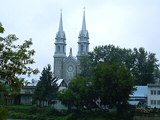
Saint-Casimir is a small village of about 1800 people in the Portneuf Regional County Municipality in the province of Quebec, Canada. It is located on the Sainte-Anne River, about 80 kilometres (50 mi) southwest of Quebec City and 50 kilometres (31 mi) northeast of Trois-Rivières.

Route 363 is a 53 kilometres (33 mi) south-north route in Quebec, Canada, going from Route 138 in Deschambault-Grondines along the St-Lawrence river to Lac-aux-Sables.

The municipal history of Quebec started in 1796 with the creation of administrations for Montréal and Quebec City, but it really developed immediately prior to the creation of the Province of Canada in 1841 with the formation of municipal districts, followed in March 1845 when the Parliament of the Province of Canada adopted an Act to create local authorities in Lower Canada which took effect in July 1845.
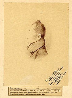
Thomas Baillairgé was both a wood carver and architect, following the tradition of the family. He was the son of François Baillairgé and the grandson of Jean Baillairgé, both men being termed architects under the definition of the time. The family had been based in Quebec since 1741 and Thomas attended English school and then the Petit Séminaire de Québec. During the latter time, he would also have begun to learn wood carving and architecture.
Area codes 418, 581, and 367 are telephone area codes in the North American Numbering Plan (NANP) for the eastern portion of the Canadian province of Quebec. Area code 418 was originally assigned to the numbering plan area, but all three area codes now form an overlay plan for this territory. Cities in the numbering plan area include Quebec City, Saguenay, Lévis, Rimouski, Saint-Georges, Alma, Thetford Mines, Sept-Îles, Baie-Comeau and Rivière-du-Loup. Also served are the Gaspé Peninsula, Côte-Nord, southeastern Mauricie, and the tiny hamlet of Estcourt Station, in the U.S. state of Maine.

Lac-aux-Sables is a parish municipality in the Mékinac Regional County Municipality, in administrative district of the Mauricie region of the province of Quebec in Canada. Its population centres are Lac-aux-Sables and Hervey-Jonction.

Notre-Dame-de-Montauban is a municipality in the Mauricie region in Canada. This municipality is located at the northern edge of regional county municipality of Mékinac Regional County Municipality and the administrative region of Mauricie. It includes the population centres of Notre-Dame-des-Anges and Montauban-les-Mines. Both communities are located along route 367, about 7 kilometres (4.3 mi) apart.

The Batiscan River is located in La Mauricie administrative region, in the Quebec province, Canada. This river flows 196 kilometres (122 mi) from Lake Édouard in Mauricie south and west to empty into the St. Lawrence River at Batiscan, Quebec, northeast of Trois-Rivières, Quebec. It passes through the regional county municipalities (RCM) of La Tuque, Portneuf, Mékinac and Les Chenaux.
Batiscanie is the watershed of the Batiscan River, located in the center of the province of Quebec, Canada, covering 4690 km² on the North Shore of the St. Lawrence River. The area covered by Batiscanie is 53% in the administrative région of Mauricie and 47% in the administrative region of the Capitale-Nationale.
Lake Charest (Mékinac) is located in the area Montauban-les-Mines, in the municipality of Notre-Dame-de-Montauban, in the Mékinac Regional County Municipality (RCM), in the extreme east of the administrative region of Mauricie, in Québec, Canada.
The Noire River flows in the municipality of rivière-à-Pierre, Saint-Alban and Saint-Casimir, in the Portneuf Regional County Municipality, in the administrative region of Capitale-Nationale, in Quebec, in Canada.
Lake Montauban is crossed by Noire River, in the municipality of Saint-Alban, in the Portneuf Regional County Municipality, in the administrative region of the Capitale-Nationale, in the Quebec, in Canada.
The Rivière des Pins is a freshwater stream, in Quebec, in Canada. This river crosses the municipalities of:
Portneuf was an electoral district of the Legislative Assembly of the Parliament of the Province of Canada, in Canada East, immediately west of Quebec City. It was created in 1841 and was based on the previous electoral district of the same name for the Legislative Assembly of Lower Canada. It was represented by one member in the Legislative Assembly.
The rivière du Moulin is a tributary of the northwest shore of the Saint-Laurent river, descending in the municipality of Deschambault-Grondines, in the Portneuf Regional County Municipality, in the administrative region of Capitale-Nationale, in Quebec, in Canada.
The Rivière des Étangs is a tributary of the rivière du Moulin, descending in the municipality of Saint-Casimir and Deschambault-Grondines, in the Portneuf Regional County Municipality, in the administrative region of Capitale-Nationale, in Quebec, in Canada.