Saint-Ubalde, Quebec

Last updated
Saint-Ubalde
Rue Saint-Paul - Saint-Ubalde.JPG
Blason ville ca Saint-Ubalde (Quebec).svg
Coat of arms
Saint-Ubalde Quebec location diagram.png
Location within Portneuf RCM
Canada Central Quebec location map.png
Red pog.svg
Saint-Ubalde
Location in central Quebec
Coordinates: 46°45′N72°16′W / 46.750°N 72.267°W / 46.750; -72.267 Coordinates: 46°45′N72°16′W / 46.750°N 72.267°W / 46.750; -72.267 [1]
CountryFlag of Canada (Pantone).svg  Canada
Province Flag of Quebec.svg  Quebec
Region Capitale-Nationale
RCM Portneuf
Settled1860
ConstitutedMarch 3, 1973
Government
[2]
  MayorPierre Saint-Germain
   Federal riding Portneuf—Jacques-Cartier
   Prov. riding Portneuf
Area
  Total146.40 km2 (56.53 sq mi)
  Land140.21 km2 (54.14 sq mi)
Population
 (2011) [3]
  Total1,403
  Density10.0/km2 (26/sq mi)
  Pop 2006-2011
Decrease2.svg 3.8%
  Dwellings
1,015
Time zone UTC−5 (EST)
  Summer (DST) UTC−4 (EDT)
Postal code(s)
Area code(s) 418 and 581
HighwaysQc363.svg Route 363
Website saintubalde.com OOjs UI icon edit-ltr-progressive.svg

Saint-Ubalde is a rural municipality in Portneuf County in the Canadian province of Quebec.

Contents

Geographically its territory is marked by an agricultural and populated area in the south-west, and an undeveloped hilly area in the north-east where there are numerous lakes such as Blanc, Sainte-Anne, Ricard, and Thom. Therefore its economy is centred on potato cultivation and outdoor recreation (canoeing, water skiing, fishing). [1]

History

Saint-Ubald (originally without an "e") was founded by people from Neuville in 1860, and the Saint-Ubald Mission was established that same year. It was named after Ubald Gingras (1824-1874), first sacristan of the place but originally from Pointe-aux-Trembles (Portneuf), and who was brother-in-law of Charles-François Baillargeon, archbishop of Quebec. The mission became a parish in 1866 by separating from Saint-Casimir. In 1873, the civil parish was formed and incorporated as a parish municipality. A year later, its post office opened. [1]

In 1920, the village centre separated from the parish municipality to form the Village Municipality of Saint-Ubalde. But in 1973, the parish and village municipalities merged again to form the new Municipality of Saint-Ubalde. [1]

Demographics

Population trend: [4]

Private dwellings occupied by usual residents: 646 (total dwellings: 1015)

Mother tongue:

See also

Related Research Articles

Saint-Casimir, Quebec Municipality in Quebec, Canada

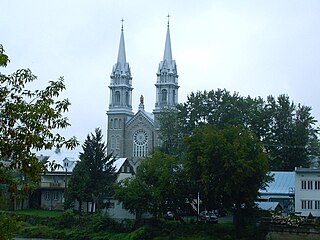
Saint-Casimir is a small village of about 1800 people in the Portneuf Regional County Municipality in the province of Quebec, Canada. It is located on the Sainte-Anne River, about 80 kilometres (50 mi) southwest of Quebec City and 50 kilometres (31 mi) northeast of Trois-Rivières.

Sainte-Anne-de-la-Pérade Municipality in Quebec, Canada

Sainte-Anne-de-la-Pérade is a municipality in the Les Chenaux Regional County Municipality, in the Mauricie region of the province of Quebec in Canada. The town is located near the mouth of the Sainte-Anne River along the Chemin du Roy, a historic segment of Quebec Route 138 that stretches from near Montreal to Quebec City.

Louiseville City in Quebec, Canada

Louiseville is a town in the Mauricie region of the province of Quebec in Canada. It is located near the mouth of the 'Rivière-du-Loup', on the north shore of Lac Saint-Pierre.

Sainte-Christine-dAuvergne, Quebec Municipality in Quebec, Canada

Sainte-Christine-d'Auvergne is a small village in the Portneuf Regional County in the province of Quebec, Canada. It is located on the south shore of the Sainte-Anne River on Route 354, between St-Casimir and St-Raymond.

Saint-Alexis-des-Monts, Quebec Parish municipality in Quebec, Canada

Saint-Alexis-des-Monts is a parish municipality in the Mauricie region of the province of Quebec in Canada.

Notre-Dame-de-Montauban, Quebec Municipality in Quebec, Canada

Notre-Dame-de-Montauban is a municipality in the Mauricie region in Canada. This municipality is located at the northern edge of regional county municipality of Mékinac Regional County Municipality and the administrative region of Mauricie. It includes the population centres of Notre-Dame-des-Anges and Montauban-les-Mines. Both communities are located along route 367, about 7 kilometres (4.3 mi) apart.

Saint-Basile, Quebec City in Quebec, Canada

Saint-Basile is a municipality situated in Portneuf Regional County Municipality in the Canadian province of Quebec.

Neuville, Quebec City in Quebec, Canada

Neuville is a village on the north shore of the Saint Lawrence River, just west of Quebec City, part of the Portneuf Regional County Municipality, Quebec, Canada. It was founded in 1684, and remains picturesque.

Portneuf, Quebec City in Quebec, Canada

Portneuf is a municipality in the Portneuf Regional County Municipality, in the province of Quebec, Canada. It is located on the Saint Lawrence River, between Quebec City and Trois-Rivières. The Portneuf River runs on the east side of the town centre.

Saint-Marc-des-Carrières City in Quebec, Canada

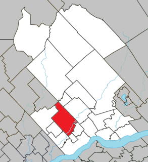
Saint-Marc-des-Carrières is a town in Quebec, Canada, part of Portneuf Regional County Municipality in the Capitale-Nationale region.

Saint-Gabriel-de-Brandon, Quebec Municipality in Quebec, Canada

Saint-Gabriel-de-Brandon is a municipality in the D'Autray Regional County Municipality in the Lanaudière region of Quebec, Canada.

Saint-Gabriel, Quebec City in Quebec, Canada

Saint-Gabriel is a town in the Lanaudière region of Quebec, Canada, part of the D'Autray Regional County Municipality. It is located on the shores of Lake Maskinongé, in the shadows of the Laurentian Mountains.

Métabetchouan–Lac-à-la-Croix City in Quebec, Canada

Métabetchouan–Lac-à-la-Croix is a city in Quebec, Canada, in the Saguenay–Lac-Saint-Jean region.

Saint-Siméon, Capitale-Nationale, Quebec Municipality in Quebec, Canada

Saint-Siméon is a municipality in the Charlevoix-Est Regional County Municipality of Quebec, Canada. Founded in 1869, it was named after Saint Simeon of Jerusalem.

Saint-Joachim, Quebec Parish municipality in Quebec, Canada

Saint-Joachim is a parish municipality in Quebec, Canada. It is part of the La Côte-de-Beaupré Regional County Municipality in the Capitale-Nationale region. Located at the foot of Cape Tourmente, it is home to the Cap Tourmente National Wildlife Area and Canyon Sainte-Anne.

Saint-Gilbert, Quebec Parish municipality in Quebec, Canada

Saint-Gilbert is a parish municipality in the Portneuf Regional County Municipality in the Capitale-Nationale region of Quebec, Canada. It has the smallest population of all municipalities in Portneuf RCM.

Saint-Alban, Quebec Municipality in Quebec, Canada

Saint-Alban is a municipality in the Capitale-Nationale region of Quebec, Canada. The place is known for its caves and crevices, and the gorge of the Sainte-Anne River. The "gorge" sector of the Sainte-Anne River is famous for its rock climbing walls.

Saint-Léonard-de-Portneuf Municipality in Quebec, Canada

Saint-Léonard-de-Portneuf is a municipality in the Capitale-Nationale region of Quebec, Canada.

La Doré, Quebec Parish municipality in Quebec, Canada

La Doré is a parish municipality in Quebec, Canada, in the regional county municipality of Le Domaine-du-Roy and the administrative region of Saguenay–Lac-Saint-Jean.

Ragueneau, Quebec Parish municipality in Quebec, Canada

Ragueneau is a parish municipality in Quebec, Canada, on Outardes Bay on the north shore of the Saint Lawrence River.

References

  1. 1 2 3 4 "Saint-Ubalde (municipalité)" (in French). Commission de toponymie du Québec. Retrieved 2010-03-29.
  2. 1 2 Ministère des Affaires municipales, des Régions et de l'Occupation du territoire - Répertoire des municipalités: Saint-Ubalde
  3. 1 2 Statistics Canada 2011 Census - Saint-Ubalde census profile
  4. Statistics Canada: 1996, 2001, 2006, 2011 census

Commons-logo.svg Media related to Saint-Ubalde at Wikimedia Commons