
Kingston is a city in Ontario, Canada, on the northeastern end of Lake Ontario. It is at the beginning of the St. Lawrence River and at the mouth of the Cataraqui River, the south end of the Rideau Canal. Kingston is midway between Toronto, Ontario, and Montreal, Quebec, and is also near the Thousand Islands, a tourist region to the east, and the Prince Edward County tourist region to the west. Kingston is nicknamed the "Limestone City" because it has many heritage buildings constructed using local limestone.
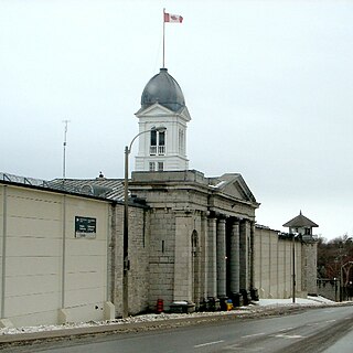
Kingston Penitentiary is a former maximum security prison located in Kingston, Ontario, Canada, between King Street West and Lake Ontario.

The Beaches is a neighbourhood in Toronto, Ontario, Canada. It is so named because of its four beaches situated on Lake Ontario. It is located east of downtown within the "Old" City of Toronto. The approximate boundaries of the neighbourhood are from Victoria Park Avenue on the east to Kingston Road on the north, along Dundas Street to Coxwell Avenue on the west, south to Lake Ontario. The Beaches is part of the east-central district of Toronto.

Portsea Island is a flat and low-lying natural island 24.5 square kilometres in area, just off the southern coast of Hampshire in England. Portsea Island contains the majority of the city of Portsmouth.
Collins Bay is a bay and natural harbour, as well as a community, within the western part of the municipality of Kingston, Ontario, Canada. Collins Bay was at one time a small village, but it became absorbed by the city of Kingston. Now Collins Bay consists mostly of residential subdivisions, a large conservation area, Kingston Norman Rogers Airport, and areas of agricultural land. The Collins Bay marina is situated on the bay itself. To the east is a large federal penitentiary, Collins Bay Institution.

The Toronto Street Railway (TSR) was the operator of a horse-drawn streetcar system from 1861 to 1891 in Toronto, Ontario, Canada. Its successor, the Toronto Railway Company, inherited the horsecar system and electrified it between 1892 and 1894.

Danforth Avenue and Danforth Road are two historically-related arterial streets in Toronto, Ontario, Canada. Danforth Avenue is an east-west street that begins in Old Toronto at the Prince Edward Viaduct as a physical continuation of Bloor Street and continues for about 6 kilometres (3.7 mi) east through old Toronto, about 350 metres (1,150 ft) of old East York, and a further 5 kilometres (3.1 mi) in Scarborough until it intersects with Kingston Road via a ramped interchange. Danforth Road splits off the Avenue west of Warden Avenue and runs diagonally northeast until south of Lawrence Avenue, where it continues as McCowan Road.
Kingston was a federal electoral district represented in the House of Commons of Canada from 1867 to 1925 and from 1953 to 1968. It was located in the province of Ontario. It was created by the British North America Act of 1867, and initially consisted of the city of Kingston, Ontario. In 1903, it was expanded to include the village of Portsmouth.

The Kingston Memorial Centre is a 3,300-seat multi-purpose arena located at 303 York Street in Kingston, Ontario, Canada. Opened in 1951, the Kingston Community Memorial Health and Recreation Centre was designed as a community sports and entertainment centre that would become a "living memorial" in remembrance of Kingstonians who gave their life in both world wars and the Korean War. The Memorial Centre lands and facilities include a war memorial, a large ice pad in the arena building, a new outdoor aquatic centre, agricultural barns, softball diamonds, a cinder track, off leash dog park and a linear park at the east, north and west perimeter of the property. Just east of the arena building was the International Hockey Hall of Fame (IHHOF) museum building at 277 York St. In July 2012, Kingston City Council approved the relocation of the collection on a short-term basis to the Invista Centre on Gardiners Road in Kingston. The existing building was found to have costly repair issues related to moisture penetration. It was demolished after the IHHOF moved to the Invista Centre in Kingston's west end.

Richardson Memorial Stadium, officially named George Taylor Richardson Memorial Stadium, is the football stadium for Queen's University, in Kingston, Ontario. The stadium is primarily used for Canadian football but also has hosted other sporting events such as soccer and rugby.

Eastern Avenue is an east-west street in Toronto, Ontario, Canada. It runs from just east of Parliament Street in the downtown to just west of Coxwell Avenue, near the Beaches neighbourhood. Originally Eastern crossed the Don River at the Old Eastern Avenue Bridge, but that bridge was disconnected in 1964. Today, Eastern's east and west halves cross the Don River north of the old alignment via a large bridge with ramps connecting to the Don Valley Parkway, and this viaduct forks out and becomes the eastern terminus of both Richmond and Adelaide streets.

The Upper Beaches is a neighbourhood in Toronto, Ontario, Canada. It is directly north of the Beaches area. It stretches from Coxwell Avenue in the west to Victoria Park in the east. The southern border is Kingston Road, while the northern boundary is generally considered to be the Canadian National Railway tracks between Gerrard Street and Danforth Avenue. The western part of the area was originally called Norway, and the larger area was once part of the Town of East Toronto. The name "Upper Beaches" was first used by developers and real estate agents around the period of 2001 to 2003 for the selling of houses on redeveloped land in the area, and was used as a marketing tag to attract buyers. The area was never considered part of the Beaches neighbourhood but was close to it. The city's current name for this area is East End Danforth, though that is rarely used. The city also includes the buildings along and just north of Danforth Avenue in the neighbourhood. The western portion between Woodbine Avenue and Coxwell is referred to by the city as Woodbine Corridor.

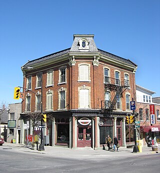
Princess Street is a major arterial road in Kingston, Ontario, Canada. As the main retail street of downtown Kingston, it is lined by many historic limestone buildings in the city's downtown core.
Inner Harbour is a neighbourhood located in downtown Kingston, Ontario, Canada. The Inner Harbour district is bounded by Joseph Street to the north, Princess Street to the south, Division Street on the west and the Cataraqui River on the east. The area is within the King's Town District. The District is represented on Kingston City Council by Councillor Rob Hutchison for the 2010-14 term of office.
Providence Care is a teaching hospital affiliated with Queen's University located in Kingston, Ontario that was built in 1861. Providence Care is a not-for-profit organization governed by a volunteer Board of Directors and sponsored by the Catholic Health Corporation of Ontario. The Worship Centre overlooks Lake Ontario and was designed with input from faith leaders from the Kingston, Ontario community. Providence Care has 585 patient beds. Providence Care is a partner within Kingston's University hospitals in the Southeast LHIN, delivering health care, conducting research and training health care professionals.
Portsmouth Olympic Harbour is a harbour located in Kingston, Ontario,. The harbour was redeveloped for the sailing events of the 1976 Summer Olympics in Montreal.
James Richardson was a Canadian businessman, founder of James Richardson and Sons, Limited, politician, and a colleague and personal friend of Sir John A. Macdonald. James had two sons: George Armstrong Richardson and Henry Westman Richardson.
William Coverdale was an English-born builder and architect in Canada West.
George Nicholas Speal, was a lawyer and political figure in Ontario, Canada. He served as mayor of Kingston from 1973 to 1976.

Rockwood Asylum was one of the first criminal asylums in Upper Canada, established in 1859 in Kingston, Ontario. Although methodologies of patient care changed drastically throughout its existence, the facility existed as some form of psychiatric hospital until its closure in 2000. The ominous four-storey building remains on its original property just west of Portsmouth, just a few metres inland from the shore of Lake Ontario.
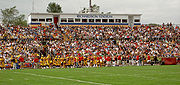 Richardson Memorial Stadium
 Home in Portsmouth Village

