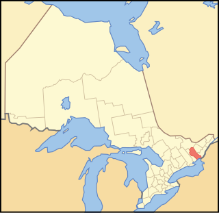
Kingston City Hall (Ontario)

Last updated

Kingston City Hall
Kingston City Hall (NHSC chart).jpg
Kingston City Hall, 2008
Location Kingston, Ontario, Canada
Built1844
Original use City hall, market, custom house, post office, police station, jail, and other uses
Current useCity hall
Architect George Browne
Architectural style(s) Neoclassical
Governing bodyCity of Kingston
Designated1961

Kingston City Hall is the seat of local government in Kingston, Ontario, Canada. Occupying a full city block facing Lake Ontario in Kingston's downtown, the city hall is a prominent building constructed in the Neoclassical style with a landmark tholobate and dome.

Contents

Market Square and Kingston City Hall, 2014 Kingston Ontario Canada - Laslovarga (28).JPG
Market Square and Kingston City Hall, 2014

The city hall was completed in 1844, with its scale and design reflective of Kingston's status as the capital of the Province of Canada at that time. The architect chosen for the project in 1841 was George Browne, and the building was believed to be one of Browne's most outstanding works.

The building was designated a National Historic Site of Canada in 1961. [1]

History

On 18 April 1840 a fire destroyed much of the downtown section of Kingston, including the market area, the market building, and the original municipal offices located in the Baker Building on King Street facing Market Square. Mayor John Counter proposed a new market building and municipal building. Since Kingston was, at the time, the capital of the new Province of Canada, the appearance of the new town hall was planned to reflect the city’s status as the capital.

Architect George Browne, who had moved to Kingston from Quebec with the new government, won the design contest and drew the plans. He also took charge of construction. The final phase of construction, however, was overseen by William Coverdale after Browne was dismissed. [2] The cornerstone was laid on 5 June 1843 by Governor General Charles Metcalfe at the location of the market overlooking the waterfront. The building was completed by November 1844. [3]

The new city hall was constructed of limestone in the form of a T and incorporated a new market building that extended west toward King Street. Known as the market "shambles", this wing of the city hall was designed as a public market and was used by hucksters, butchers and green grocers who occupied stalls. The market wing also included a clock tower. In 1865 the wing was destroyed by a fire. It was rebuilt with a smaller configuration but without the clock tower, and the clock was placed into the main dome. A fire in 1908 destroyed the main dome, which was reconstructed with a new clock. [4]

Since Kingston entered into a recession when the seat of government moved to Montreal in May 1844, town council was concerned about paying for the large building and so began renting out space. Tenants included the post office, customs offices, the Masons, the Orange Order, a saloon, a dry goods store, an amateur theatre, the Mechanics Institute, the Bank of British North America, and the Scottish Free Church. The west wing was rented out for lectures, meetings, bazaars and balls. Welfare recipients were housed in the basement but this proved to be unsuccessful and the tenants were evicted. [5] [6]

The portico at the front entrance was removed in 1956 because of deterioration but was restored in 1966. To commemorate Kingston's tercentenary in 1973, the interior of the building was renovated and restored. [7]

Memorial Hall, located in the north wing, includes twelve stained glass windows that pay tribute to those who fought in several First World War battles. [8]

John A. Macdonald, Canada's first prime minister, lay in state here following his death on 6 June 1891.

Police headquarters

Kingston’s police force set up its headquarters in the basement of City Hall as soon as the building opened in 1844. The space consisted of a large room, four cells and the Police Court. In the early 1900s, the police offices and Police Court moved to the main floor. In 1952 the police offices moved into two floors of the attached Market Building, which had been renovated. Police holding cells were located on the main floor, while the second floor housed the main offices and Magistrate’s Court. As the force expanded, it outgrew its allotted space and so the police headquarters moved into a separate building, which was completed in 1972. It has since moved into even larger quarters. [9] [10]

Market Square

Springer Market Square, located directly behind city hall, holds a seasonal farmers' market, the Kingston Public Market, on Tuesdays, Thursdays and Saturdays from April until November, although in the early years the market was held summer and winter. It is the oldest public market in the province. [11] [12] An antiques market operates in the square on Sundays. [13] The square was revitalized during 2005–07, creating an outdoor skating rink and small amphitheatres in the north and south courtyards of city hall. [14]

Market Square and Kingston City Hall, ca. 1900 Kingston City Hall & Market Square ca. 1900.jpg
Market Square and Kingston City Hall, ca. 1900

Market Square was created as part of the original town plan of 1784 [15] and was the site of an informal market established in 1788. The square originally extended to the waterfront. [16] It was the only location in Kingston where farmers could sell their produce, which was brought in by wagon or cart. The Kingston Public Market was officially established by the City of Kingston in 1801, and the rules and regulations were proclaimed in May 1811. It was the centre of commerce and trade in the city and through the 19th century public buildings, hotels, and shops developed around the square including Kingston City Hall which was built in 1844. [15] [17] As the city grew, the market came to consist of ramshackle wooden stalls known as the market shambles, which were destroyed, along with many of the surrounding buildings, in the Great Fire of 1840. [18] [11] [15] After the fire, the market area was rebuilt with a new market building, which was attached to the new city hall. The market was deeded to the city in 1848. [16]

In 1758 British Colonel John Bradstreet's infantry used the site when they bombarded the French Fort Frontenac during the Battle of Fort Frontenac. [16] The square was the location where the first Lieutenant Governor of Upper Canada, John Graves Simcoe, proclaimed the Constitutional Act 1791 which established Upper Canada as a separate jurisdiction, where the beginning of the War of 1812 was announced, and in 1867, was the location where Canadian Confederation was proclaimed. The square was also used as an assembly point for soldiers who participated in the North-West Rebellion and fought in the First and Second World Wars.

Archaeological investigations that took place in 2002 and 2003 in preparation for the revitalization project uncovered evidence of old commercial buildings, the old market and market wing, remnants of part of the nearby Fort Frontenac, and signs of the two major fires that occurred in 1840 and 1865. [11]

Market Square was renamed "Springer" Market Square in 2008 to recognize the donation of $1 million to the City of Kingston by the Springer family to help pay for the revitalization of the square. [19]

Confederation Park

Kingston City Hall and the Market Battery, 1857 Kingston City Hall & Market Battery.jpg
Kingston City Hall and the Market Battery, 1857
Confederation Park, Kingston City Hall and a reconstructed wall of the Market Battery Kingston City Hall Andrew pmk.JPG
Confederation Park, Kingston City Hall and a reconstructed wall of the Market Battery

Confederation Park, which is associated with Kingston City Hall, separates the city hall from the waterfront. Established in 1967 on formerly-industrial waterfront land, it includes a large arch with a fountain and the Confederation Basin Marina. A former Kingston and Pembroke Railway (K&P) station which once served as the southern terminus of the now-defunct line is now a visitor information centre operated by Tourism Kingston. A restored historic locomotive, the "Spirit of Sir John A.", recalls downtown Kingston's past role in locomotive manufacturing.

Market Battery

A fortification known as the Market Battery, was located on the waterfront directly in front of City Hall where Confederation Park is located. It was completed in 1848 because of tension between the United States and Great Britain during the Oregon Crisis. The Market Battery was one of several Kingston fortifications constructed during this period. A thick outer wall, or sea wall, in the harbour extended 20 feet above the water and included embrasures for cannons, while an inner wall, which included an entrance, completed the battery's enclosure to the west. In the 1870s, after Imperial troops withdrew from Kingston, the inner wall was removed and the location became a park. The large outer wall was removed in 1885 and the land was leased to the K&P railroad. A wall of the battery has been restored to illustrate the site's history. [20]

Kingston City Hall appears in the 1999 HBO movie, Vendetta. [21]

Kingston City Hall, Market Square, and the surrounding buildings appear as part of a Russian city in the fourteenth episode of the television series, Nikita's, third season, The Life We've Chosen in 2013. [22] [23]

Kingston City Hall also appears briefly as an unnamed government building in Buffalo, New York, in 2015's Crimson Peak. [24] [25] [26] [27] [28] [29]

Kingston City Hall and Market Square appeared on the seventh episode of The Amazing Race Canada 4 in 2016. [30]

Kingston City Hall and Market Square appeared in the Murdoch Mysteries episode "Rigid Silence" in 2020. [31]

See also

Related Research Articles

<span class="mw-page-title-main">Kingston, Ontario</span> City in Ontario, Canada

Kingston is a city in Ontario, Canada. It is located on the north-eastern end of Lake Ontario, at the beginning of the St. Lawrence River and at the mouth of the Cataraqui River. The city is midway between Toronto, Ontario and Montreal, Quebec. Kingston is also located nearby the Thousand Islands, a tourist region to the east, and the Prince Edward County tourist region to the west. Kingston is nicknamed the "Limestone City" because of the many heritage buildings constructed using local limestone.

<span class="mw-page-title-main">Greater Napanee</span> Town in Ontario, Canada

Greater Napanee is a town in southeastern Ontario, Canada, approximately 45 kilometres (28 mi) west of Kingston and the county seat of Lennox and Addington County. It is located on the eastern end of the Bay of Quinte. Greater Napanee municipality was created by amalgamating the old Town of Napanee with the townships of Adolphustown, North and South Fredericksburgh, and Richmond in 1999. Greater Napanee is co-extensive with the original Lennox County.

<span class="mw-page-title-main">St. Lawrence, Toronto</span> Neighbourhood in Canada, Ontario, Toronto

St. Lawrence is a neighbourhood located in downtown Toronto, Ontario, Canada. The area, a former industrial area, is bounded by Yonge, Front, and Parliament Streets, and the Canadian National railway embankment. The Esplanade off Yonge St., lined with restaurants, cafés and hotels runs through the middle of the area. In previous times, the area was sometimes referred to as 'St. Lawrence Ward' or more often today as 'St. Lawrence Market', synonymous with the large retail vendor market which is the neighbourhood's focal point. The area is the site of a large city-sponsored housing project of the 1970s, which revitalized an old brownfields area. The boundaries of the St Lawrence Neighbourhood Association and the St Lawrence Market BIA are somewhat larger than those noted above. Both groups have boundaries that extend from Yonge to Parliament Streets and Queen Street East to the rail corridor.

<span class="mw-page-title-main">Fort Henry National Historic Site</span> National historic site and fort in Kingston, Ontario

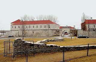
Fort Henry National Historic Site is located in Kingston, Ontario, Canada on Point Henry, a strategic, elevated point near the mouth of the Cataraqui River where it flows into the St. Lawrence River at the east end of Lake Ontario. The fort and the point on which the fort was built were named after Henry Hamilton, former Lieutenant-Governor of the Province of Quebec.

<span class="mw-page-title-main">Frontenac County</span> County in Ontario, Canada

Frontenac County is a county and census division of the Canadian province of Ontario. It is located in the eastern portion of Southern Ontario. The city of Kingston is in the Frontenac census division, but is separated from the County of Frontenac.

<span class="mw-page-title-main">Fort Frontenac</span> French fort in Kingston, Ontario, Canada

Fort Frontenac was a French trading post and military fort built in July 1673 at the mouth of the Cataraqui River where the St. Lawrence River leaves Lake Ontario, in a location traditionally known as Cataraqui. It is the present-day location of Kingston, Ontario, Canada. The original fort, a crude, wooden palisade structure, was called Fort Cataraqui but was later named for Louis de Buade de Frontenac, Governor of New France who was responsible for building the fort. It was abandoned and razed in 1689, then rebuilt in 1695.

<span class="mw-page-title-main">Kingston Memorial Centre</span>

The Kingston Memorial Centre is a 3,300-seat multi-purpose arena located at 303 York Street in Kingston, Ontario, Canada. Opened in 1951, the Kingston Community Memorial Health and Recreation Centre was designed as a community sports and entertainment centre that would become a "living memorial" in remembrance of Kingstonians who gave their life in both world wars and the Korean War. The Memorial Centre lands and facilities include a war memorial, a large ice pad in the arena building, a new outdoor aquatic centre, agricultural barns, softball diamonds, a cinder track, off leash dog park and a linear park at the east, north and west perimeter of the property. Just east of the arena building was the International Hockey Hall of Fame (IHHOF) museum building at 277 York St. In July 2012, Kingston City Council approved the relocation of the collection on a short-term basis to the Invista Centre on Gardiners Road in Kingston. The existing building was found to have costly repair issues related to moisture penetration. It was demolished after the IHHOF moved to the Invista Centre in Kingston's west end.

<span class="mw-page-title-main">Kingston station (Ontario)</span> Railway station for Kingston, Ontario, Canada

The Kingston railway station is an inter-city passenger rail station in Cataraqui, Kingston, Ontario, Canada. It is served by Via Rail trains running from Toronto to Ottawa or Montreal, along the Corridor route. It is located on John Counter Boulevard, northeast of Princess Street and north-west of downtown Kingston.

<span class="mw-page-title-main">Downtown Winnipeg</span> Neighbourhood in Winnipeg, Manitoba, Canada

Downtown Winnipeg is an area of Winnipeg located near the confluence of the Red and Assiniboine rivers. It is the oldest urban area in Winnipeg, and is home to the city's commercial core, city hall, the seat of Manitoba's provincial government, and a number of major attractions and institutions.

<span class="mw-page-title-main">Downtown Toronto</span> Central business district in Toronto, Ontario, Canada

Downtown Toronto is the main central business district of Toronto, Ontario, Canada. Located entirely within the district of Old Toronto, it is approximately 16.6 square kilometres in area, bounded by Bloor Street to the northeast and Dupont Street to the northwest, Lake Ontario to the south, the Don Valley to the east, and Bathurst Street to the west. It is also the home of the municipal government of Toronto and the Government of Ontario.

<span class="mw-page-title-main">Leon's Centre</span> Indoor arena in downtown Kingston, Ontario

Leon's Centre is an indoor arena in downtown Kingston, Ontario. Opened in 2008, it is the home of the Kingston Frontenacs of the Ontario Hockey League.

<span class="mw-page-title-main">Kingston General Hospital</span> Hospital in Ontario, Canada

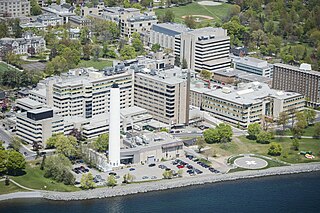
The Kingston General Hospital (KGH) site is an acute-care teaching hospital affiliated with Queen's University located in Kingston, Ontario, Canada. Along with the Hotel Dieu Hospital (HDH) site, these hospitals deliver health care services to more than 500,000 residents throughout southeastern Ontario; conduct health care research and train future health care professionals.

<span class="mw-page-title-main">Princess Street (Kingston, Ontario)</span>

Princess Street is a major arterial road in Kingston, Ontario, Canada. As the main retail street of downtown Kingston, it is lined by many historic limestone buildings in the city's downtown core.

<span class="mw-page-title-main">La Salle Causeway</span> Causeway in Kingston, Ontario

The La Salle Causeway is a causeway that allows Highway 2 to cross the Cataraqui River at Kingston, Ontario. The causeway separates Kingston's inner and outer harbours. Construction of the causeway was completed on April 15, 1917.

<span class="mw-page-title-main">Sydenham Ward</span> Neighbourhood in Ontario, Canada

Sydenham is a central business district located in Kingston, Ontario, Canada. The Sydenham district for census purposes is bounded by Lake Ontario to the south and east, by Princess Street to the north and Barrie Street to the west. These boundaries do not coincide with the Sydenham Ward boundaries for city councillor elections as they include parts of the downtown main street.

The history of Ottawa, capital of Canada, was shaped by events such as the construction of the Rideau Canal, the lumber industry, the choice of Ottawa as the location of Canada's capital, as well as American and European influences and interactions. By 1914, Ottawa's population had surpassed 100,000 and today it is the capital of a G7 country whose metropolitan population exceeds one million.

Point Frederick is a 41-hectare (101-acre) peninsula in Kingston, Ontario, Canada. The peninsula is located at the south end of the Rideau Canal where Lake Ontario empties into the St. Lawrence River. Point Frederick is bounded by the Cataraqui River to the west, the St. Lawrence River to the south, and Navy Bay to the east. The peninsula is occupied by the Royal Military College of Canada (RMC). Several of the buildings located on Point Frederick and the site of the old naval dockyard are national historic sites. Fort Frederick, at the south end of the peninsula, is a feature of the Kingston Fortifications National Historic Site of Canada.

Lily Inglis (1926-2010) was a Canadian architect born in Milan, Italy and received her education in England. She moved to Canada and joined the Ontario Association of Architects, becoming involved in the preservation of historic buildings in Kingston, Ontario. Inglis was also a member of Royal Institute of British Architects (1953) and Royal Architectural Institute of Canada (1985). She was a partner in Inglis and Downey Architects, Inc. She made a strong name for herself by proving to clients that even as a woman she was able to solve complex issues. This increased her creditability within the architectural field.

Captain Michael Grass (c.1734–1813) was a French-born militia captain who was loyal to the British and led a contingent of United Empire Loyalists to Canada after the American War of Independence. Grass was one of the founders of Kingston, Ontario.

References

Notes
  1. Kingston City Hall National Historic Site of Canada . Canadian Register of Historic Places . Retrieved 22 May 2012.
  2. Mika 1987, p. 108
  3. Osborne 2011, p. 102
  4. Queen’s Cabinet of Canadian Curiosities - Queen’s University Archives Retrieved October 10, 2015
  5. Mika 1987, p. 109
  6. Osborne 2011, p. 103
  7. Mika 1987, pp. 108, 109
  8. Historic City Hall Retrieved October 15, 2015
  9. Kingston Police History - A Police Force is Born Archived 2015-11-17 at the Wayback Machine Retrieved October 20, 2015
  10. Kingston Police History - Growth and Change Archived 2015-11-17 at the Wayback Machine Retrieved October 20, 2015
  11. 1 2 3 "Market Square". Cataraqui Archaeological Research Foundation. Cataraqui Archaeological Research Foundation. Archived from the original on June 26, 2015. Retrieved June 15, 2015.
  12. "About". Kingston Public Market. Archived from the original on June 18, 2015. Retrieved June 15, 2015.
  13. "Events". Kingston Public Market. Archived from the original on June 19, 2015. Retrieved June 15, 2015.
  14. "Springer Market Square". City of Kingston. City of Kingston. Retrieved June 16, 2015.
  15. 1 2 3 "Market Square History". City of Kingston. City of Kingston. Retrieved June 16, 2015.
  16. 1 2 3 Mika 1987, p. 137
  17. Osborne 2011, p. 45
  18. "History". Kingston Public Market. Archived from the original on June 19, 2015. Retrieved June 15, 2015.
  19. "Name Game for City Facilities". Kingston Whig-Standard. Kingston Whig-Standard. Retrieved October 15, 2016.
  20. Mika 1987, pp. 116-117
  21. "Kingston City Hall - Kingston, Ontario - Movie Locations on Waymarking.com". www.waymarking.com.
  22. "TV series filming downtown Monday".
  23. "Social Media Buzzing over "Nikita" Filming in Kingston". 15 January 2013.
  24. "Where Crimson Peak Was Filmed in Toronto". 6 April 2017.
  25. "Crimson Peak Filming in Kingston's Market Square". 14 April 2014.
  26. "Can You Find Kingston in this Crimson Peak Movie Trailer?". 16 October 2015.
  27. "Filming Locations: Where was Crimson Peak filmed?".
  28. "Crimson Peak Filming in Kingston, Ontario!!!". ohnotheydidnt.livejournal.com.
  29. @kingstonpolice (April 14, 2014). "Shots taken yesterday of @cityofkingston Market Square and downtown #ygk King St area for #CrimsonPeak shooting" (Tweet) via Twitter.
  30. "Married Couple Julie and Lowell from Lethbridge, Alta. are the Fifth Team Eliminated in Season 4 of CTV's THE AMAZING RACE CANADA". Bell Media. 10 August 2016. Retrieved 20 January 2020.
  31. "TV show shot in Kingston airs Monday". The Kingston Whig-Standard. 31 January 2020. Retrieved 28 August 2020.
Bibliography

44°13′48″N76°28′50″W / 44.2299°N 76.4806°W / 44.2299; -76.4806