
Cumberland is a city in and the county seat of Allegany County, Maryland, United States. At the 2020 census, the city had a population of 19,076. Located on the Potomac River, Cumberland is a regional business and commercial center for Western Maryland and the Potomac Highlands of West Virginia. It is the primary city of the Cumberland metropolitan area, which had 95,044 residents in 2020.

The Baltimore and Ohio Railroad was the first common carrier railroad and the oldest railroad in the United States with its first section opening in 1830. Merchants from Baltimore, which had benefited to some extent from the construction of the National Road early in the century, wanted to do business with settlers crossing the Appalachian Mountains. The railroad faced competition from several existing and proposed enterprises, including the Albany-Schenectady Turnpike, built in 1797, the Erie Canal, which opened in 1825, and the Chesapeake and Ohio Canal. At first, the B&O was located entirely in the state of Maryland; its original line extending from the port of Baltimore west to Sandy Hook, Maryland, opened in 1834. There it connected with Harper's Ferry, first by boat, then by the Wager Bridge, across the Potomac River into Virginia, and also with the navigable Shenandoah River.

The Western Maryland Railway was an American Class I railroad (1852–1983) which operated in Maryland, West Virginia, and Pennsylvania. It was primarily a coal hauling and freight railroad, with a small passenger train operation.

The Western Maryland Scenic Railroad (WMSR) is a heritage railroad based in Cumberland, Maryland, that operates passenger excursion trains and occasional freight trains using both steam and diesel locomotives over ex-Western Maryland Railway (WM) tracks between Cumberland and Frostburg. The railroad offers coach and first class service, murder mystery excursions, and special seasonal trips.

The Northern Central Railway (NCRY) was a Class I Railroad connecting Baltimore, Maryland with Sunbury, Pennsylvania, along the Susquehanna River. Completed in 1858, the line came under the control of the Pennsylvania Railroad (PRR) in 1861, when the PRR acquired a controlling interest in the Northern Central's stock to compete with the rival Baltimore and Ohio Railroad (B&O).
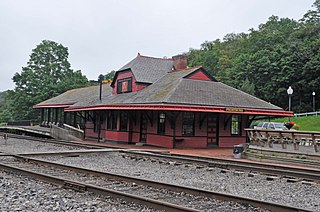
The Cumberland and Pennsylvania Railroad (C&P) was an American railroad which operated in Western Maryland. Primarily a coal hauler, it was owned by the Consolidation Coal Company, and was purchased by the Western Maryland Railway (WM) in 1944.

The Metropolitan Subdivision is a railroad line owned and operated by CSX Transportation in the District of Columbia and the U.S. state of Maryland. The 53-mile line runs from Washington, D.C., northwest to Weverton, Maryland, along the former Metropolitan Branch of the Baltimore and Ohio Railroad.

The Lurgan Branch is a railroad line owned and operated by the Norfolk Southern Railway in the U.S. states of Pennsylvania and Maryland. The line is part of the NS Harrisburg Division and runs from Harrisburg, Pennsylvania southwest to Hagerstown, Maryland along former Reading Company and Pennsylvania Railroad lines. Its northeast end is at a junction with the Harrisburg Line, Pittsburgh Line, Royalton Branch, and Amtrak's Keystone Corridor ; its southwest end is at the beginning of the Hagerstown District. At Lemoyne it intersects the Enola Branch.

The Maryland Mining Company is a historic coal mining, iron producer and railroad company that operated in Allegany County, Maryland, United States.
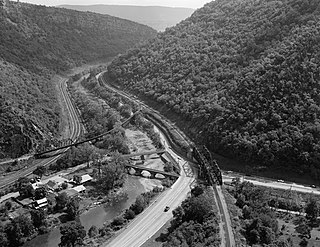
The Eckhart Branch Railroad was a railroad that operated in the Cumberland, Maryland area in the 19th century.
The Mount Savage Railroad was a railroad operated by the Maryland and New York Coal and Iron Company of Mount Savage, Maryland between 1845 and 1854. The 14.9 miles (24 km) rail line ran from Frostburg to Cumberland, Maryland.
The Georges Creek Railroad was a railroad operated by the Georges Creek Coal and Iron Company in Western Maryland. The railroad operated from 1853 to 1863, when it was acquired by the Cumberland and Pennsylvania Railroad (C&P).
The Georges Creek Coal and Iron Company is a defunct coal mining, iron producer and railroad company that operated in Maryland from 1835 to 1863.
The Georges Creek and Cumberland Railroad (GC&C) was a railroad that operated in Maryland from 1876 until 1917, when it was merged with the Western Maryland Railway (WM). The main line ran from Cumberland to Lonaconing.
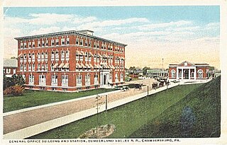
The Cumberland Valley Railroad was an early railroad in Pennsylvania, United States, originally chartered in 1831 to connect with Pennsylvania's Main Line of Public Works. Freight and passenger service in the Cumberland Valley in south central Pennsylvania from near Harrisburg to Chambersburg began in 1837, with service later extended to Hagerstown, Maryland, and then extending into the Shenandoah Valley to Winchester, Virginia. It employed up to 1,800 workers.
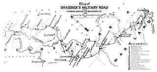
Cumberland, Maryland is named after the son of King George II, Prince William, the Duke of Cumberland. It is built on the site of the old Fort Cumberland, a launch pad for British General Edward Braddock's ill-fated attack on the stronghold of Fort Duquesne during the French and Indian War.
Maryland Route 51 is a state highway in the U.S. state of Maryland. Known for most of its length as Oldtown Road, the state highway runs 25.53 miles (41.09 km) from an interchange with Interstate 68 (I-68) in Cumberland south to the West Virginia state line at the Potomac River, where the highway continues east as West Virginia Route 9 toward Paw Paw. Around Cumberland, MD 51 is a major highway that provides a bypass of the South End neighborhood of that city and access to industrial areas along the North Branch Potomac River. South of North Branch, MD 51 is a rural highway connecting small communities along the river in southeastern Allegany County, including Oldtown. Documentation from the Maryland State Highway Administration depict the highway as following an east-west alignment, but all signage indicates a north-south road.
Canal Parkway, which carries the unsigned Maryland Route 61 designation, is a state highway and automobile parkway in the U.S. state of Maryland. The road begins at the West Virginia state line at the North Branch Potomac River opposite Wiley Ford, where the highway continues south as West Virginia Route 28. The parkway runs 1.94 miles (3.12 km) north to MD 51 within the city of Cumberland. Canal Parkway provides a connection between downtown Cumberland and the South Cumberland neighborhood and with Greater Cumberland Regional Airport, which is located in Mineral County, West Virginia.
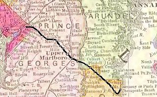
The Chesapeake Beach Railway (CBR), now defunct, was an American railroad of southern Maryland and Washington, D.C., built in the 19th century. The CBR ran 27.629 miles from Washington, D.C., on tracks formerly owned by the Southern Maryland Railroad and then on its own single track through Maryland farm country to a resort at Chesapeake Beach. The construction of the railway was overseen by Otto Mears, a Colorado railroad builder, who planned a shoreline resort with railroad service from Washington and Baltimore. It served Washington and Chesapeake Beach for almost 35 years, but the Great Depression and the rise of the automobile marked the end of the CBR. The last train left the station on April 15, 1935. Parts of the right-of-way are now used for roads and a future rail trail.
The West Virginia Central and Pittsburg Railway (WVC&P) was a railroad in West Virginia and Maryland operating in the late 19th and early 20th centuries. It had main lines radiating from Elkins, West Virginia in four principal directions: north to Cumberland, Maryland; west to Belington, WV; south to Huttonsville, WV; and east to Durbin, WV. Some of the routes were constructed through subsidiary companies, the Piedmont and Cumberland Railway and the Coal and Iron Railway.


