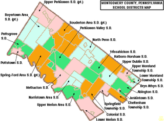
Montgomery County is the third-most populous county in the Commonwealth of Pennsylvania, and the 73rd-most populous in the United States. As of the 2020 census, the population of the county was 856,553, representing a 7.1% increase from the 799,884 residents enumerated in the 2010 census. Montgomery County is located adjacent to and northwest of Philadelphia. The county seat and largest city is Norristown. Montgomery County is geographically diverse, ranging from farms and open land in the extreme north of the county to densely populated suburban neighborhoods in the southern and central portions of the county.

East Bradford Township is a township in Chester County, Pennsylvania, United States. The population was 10,308 at the 2020 census.

Tredyffrin Township is a township located in eastern Chester County, Pennsylvania, United States. The population was 29,332 at the 2010 census. Originally settled in the late 17th century, Tredyffrin is bounded by Delaware and Montgomery counties. It includes on its northern boundary a small part of Valley Forge National Historical Park, where George Washington encamped during the American War of Independence. Tredyffrin and the entire Great Valley region also have many limestone deposits. Tredyffrin is the most populous township in Chester County.

Upper Uwchlan Township is a township in Chester County, Pennsylvania, United States. The population was 11,227 at the 2010 census. The township included the community of Milford Mills before it was inundated by the creation of the Marsh Creek Dam in 1972.

West Chester is a borough and the county seat of Chester County, in the U.S. state of Pennsylvania. Located within the Philadelphia metropolitan area, the borough had a population of 18,461 at the 2010 census. West Chester is the mailing address for most of its neighboring townships. When calculated by mailing address, the population as of the 2010 US Census was 108,696, which would make it the 10th largest city by mailing address in the state of Pennsylvania.

Upper Macungie Township is a township in Lehigh County, Pennsylvania. The population of Upper Macungie Township was 26,377 as of the 2020 U.S. census, making it the fourth fastest-growing municipality in Pennsylvania in terms of total population gain from 2010 to 2020. The township was created in 1832 when Macungie Township was divided into Upper and Lower Macungie townships. It is part of the Lehigh Valley metropolitan area, which has a population of 861,899 and is the 68th most populated metropolitan area in the U.S. as of the 2020 census.

Lower Frederick Township is a township in Montgomery County, Pennsylvania. The population was 4,840 at the 2010 census.

Lower Pottsgrove Township is a township in Montgomery County, Pennsylvania, United States about 30 miles northwest of Philadelphia and 18 miles southeast of Reading along the Schuylkill River. The population was 12,059 at the 2010 census.

Lower Providence Township is a township in Montgomery County, Pennsylvania, United States, about 17 miles northwest of Philadelphia. The population was 25,625 at the 2020 census.

Pottstown is a borough in Montgomery County, Pennsylvania. Pottstown was laid out in 1752–53 and named Pottsgrove in honor of its founder, John Potts. The old name was abandoned at the time of the incorporation as a borough in 1815. In 1888, the limits of the borough were considerably extended. Pottstown is the center of a productive farming and dairying region.

Skippack Township is a township in Montgomery County, Pennsylvania, United States. The population was 13,715 at the 2010 census. This represents a 110.5% increase from the 2000 count of 6,516 residents.

Trooper is a census-designated place (CDP) in Montgomery County, Pennsylvania, United States. The population was 5,744 at the 2010 census.

Upper Dublin Township is a township in Montgomery County, Pennsylvania, United States. The population was 25,569 at the 2010 census. Until the 1950s, Upper Dublin was mostly farmland and open space, but transitioned to a residential suburb during the postwar population boom. The population went from just over 6,000 residents in the 1950s to just under 20,000 by 1970. Today, Upper Dublin is mostly spread-out development housing, and has the fourth highest median income in Montgomery County.

Upper Merion Township is a township in Montgomery County, Pennsylvania, United States. The population was 28,395 at the 2010 U.S. Census. Located 16 miles (26 km) from Philadelphia, it consists of the villages of Gulph Mills, King of Prussia, Swedeland, Swedesburg, and portions of Radnor and Wayne.

Radnor Township, often called simply Radnor, is a first class township with home rule status in Delaware County, Pennsylvania, United States. As of the 2019 United States census estimate, the township population is 31,875. Radnor Township is the largest municipality in Delaware County by land area and the fourth-largest by population, following Upper Darby Township, Haverford Township, and Chester.

Upper Providence Township is a township in Delaware County, Pennsylvania, United States, located around and north of the borough of Media, and about 15 miles (24 km) west of center city Philadelphia. The population was 10,142 at the 2010 census. The township lies between Ridley Creek on the west and Crum Creek on the east. Most of Ridley Creek State Park is in the township towards the northern edge. Zoning is 98% residential, 1% commercial and 1% industrial, with minimal space zoned to commercial business.

The West Chester Area School District serves the borough and surrounding townships of West Chester, Pennsylvania, United States. The other parts include the surrounding townships of East Bradford, East Goshen, Thornbury, West Goshen, West Whiteland, and Westtown, all in Chester County, as well as Thornbury Township in adjacent Delaware County. The WCASD consists of ten elementary schools, three middle schools, and three high schools, as of the fall 2018 school year. There are plans to build an 11th elementary school. Elementary schools include grades 1-5, middle schools grades 6-8, and high schools grades 9-12.

The 147th Pennsylvania House of Representatives District is located in Southeastern Pennsylvania and has been represented since 2020 by Tracy Pennycuick.
Saint Pius X High School was a private, Roman Catholic high school at 844 North Keim Street in Lower Pottsgrove Township, Pennsylvania, United States, northeast of Pottstown. It was located in the Roman Catholic Archdiocese of Philadelphia.

Methacton School District (MSD) is a public school district located in Montgomery County, Pennsylvania, in the Philadelphia metropolitan area. It is headquartered in the Farina Education Center in Worcester Township.


