
Miami County is a county located in east-central Kansas and is part of the Kansas City metropolitan area. Its county seat and most populous city is Paola. As of the 2020 census, the county population was 34,191. The county was named for the Miami tribe.

Crockett is a census-designated place (CDP) in Contra Costa County, in the East Bay sub-region of the San Francisco Bay Area, California. The population was 3,094 at the 2010 census. It is located 28 miles northeast of San Francisco. Other nearby communities include Port Costa, Martinez, Vallejo, Benicia, Rodeo, Hercules, Pinole and Richmond.

The Ozarks, also known as the Ozark Mountains, Ozark Highlands or Ozark Plateau, is a physiographic region in the U.S. states of Missouri, Arkansas, Oklahoma and the extreme southeastern corner of Kansas. The Ozarks cover a significant portion of northern Arkansas and most of the southern half of Missouri, extending from Interstate 40 in central Arkansas to Interstate 70 in central Missouri.

The Battle of Pea Ridge, also known as the Battle of Elkhorn Tavern, took place during the American Civil War near Leetown, northeast of Fayetteville, Arkansas. Federal forces, led by Brig. Gen. Samuel R. Curtis, moved south from central Missouri, driving Confederate forces into northwestern Arkansas. Maj. Gen. Earl Van Dorn had launched a Confederate counteroffensive, hoping to recapture northern Arkansas and Missouri. Confederate forces met at Bentonville and became the most substantial Rebel force, by way of guns and men, to assemble in the Trans-Mississippi. Against the odds, Curtis held off the Confederate attack on the first day and drove Van Dorn's force off the battlefield on the second. By defeating the Confederates, the Union forces established Federal control of most of Missouri and northern Arkansas.

Turkey Run State Park, Indiana's second state park, is in Parke County in the west-central part of the state along State Road 47, 2 miles (3.2 km) east of U.S. 41.

The Mormon Trail is the 1,300-mile (2,100 km) long route from Illinois to Utah on which Mormon pioneers traveled from 1846–47. Today, the Mormon Trail is a part of the United States National Trails System, known as the Mormon Pioneer National Historic Trail.

The Monongahela Railway was a coal-hauling Class II railroad in Pennsylvania and West Virginia in the United States. It was jointly controlled originally by the Pennsylvania Railroad, New York Central subsidiary Pittsburgh and Lake Erie Railroad, and the Baltimore and Ohio Railroad, with NYC and PRR later succeeded by Penn Central Transportation. The company operated its own line until it was merged into Conrail on May 1, 1993.
Albert Edward Brumley was an American shape note music composer and publisher, prolific in the genre of southern gospel.
Big Sugar Creek is a 47-mile-long (76 km) waterway in the Ozark Mountains of southwest Missouri. The creek starts near the Arkansas state line. Big Sugar starts from three tributaries. One flows north from Garfield, Arkansas, and one, west near Seligman, Missouri, and another, south from Washburn, Missouri. Big Sugar flows west down Sugar Creek Valley, where in the Jacket community it is joined by Otter Creek, from Pea Ridge, Arkansas.
DeWalt or Dewalt was an unincorporated area in Fort Bend County, in the U.S. state of Texas. The former community was located on State Highway 6 between Oilfield Road and Farm to Market Road 1092 (FM 1092). DeWalt has been absorbed by the municipality of Missouri City, a Houston suburb. Though Dewalt was noted on highway signs as late as 2013, there are few surviving structures and locations from the original community. In 2006, the Dew Plantation's house was moved from DeWalt to nearby Kitty Hollow Park to preserve it as a museum. The private Dewalt Cemetery still exists within the Lake Olympia subdivision.
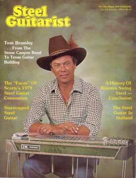
Thomas Rexton Brumley was an American pedal steel guitarist and steel guitar manufacturer. In the 1960s, Brumley was a part of the sub-genre of country music known as the "Bakersfield sound". He performed with Buck Owens and the Buckaroos on hits such as "Cryin' Time" and "Together Again". His solo on "Together Again" received particular acclaim by critics. Brumley later spent a decade with Ricky Nelson and performed on "Garden Party" and the In Concert at the Troubadour, 1969 album.
Jacket is an unincorporated community in the southeastern corner of McDonald County, Missouri, United States. It is located on Missouri Route KK, approximately one-half mile north of the Missouri-Arkansas border and one mile west of the McDonald and Barry county border. The community is on the east bank of Big Sugar Creek.
Little Sugar Creek is a stream in northwestern Benton County, Arkansas and southwestern McDonald County, Missouri. It is a tributary of the Elk River.
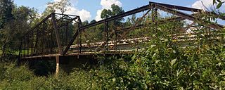
The Powell Bridge is a National Register of Historic Places site that crosses Big Sugar Creek near the community of Powell, Missouri, a rural hamlet in McDonald County, Missouri in the Ozark Mountains region. The bridge was built by the East St. Louis Bridge Co. and was opened to traffic on August 16, 1915. The single-lane pin-connected Pratt through truss was open to vehicular traffic from 1915 until a new two-lane bridge was built and opened beside it in 2015. It is currently owned by the Powell Historic Preservation Society and is one of three sites in McDonald County on the National Register of Historic Places, which also includes the Old McDonald County Courthouse. The community of Powell itself is best known as the home of famed gospel writer Albert E. Brumley.
Mikes Creek is a stream in Barry and McDonald counties of the Ozarks of southwestern Missouri.
Travers is an unincorporated community in Barry County, in the U.S. state of Missouri. The community is on the west side of Flat Creek just north of the Twin Springs in Corder Hollow. Butterfield is approximately 3.5 miles to the west and Cassville is about five mile upstream (southwest) along Flat Creek.
Cyclone is an unincorporated community in east central McDonald County, in the U.S. state of Missouri. The community is located on Big Sugar Creek west of Powell.
Havenhurst is an unincorporated community in southern McDonald County, in the U.S. state of Missouri. The community is located on Missouri Route K, just north of U.S. Route 71, approximately one mile southeast of Pineville. The site is on the bank of Little Sugar Creek.

Nepenthe is a restaurant in Big Sur, California, built by Bill and Madelaine "Lolly" Fassett and first opened in 1949. It was built around a cabin first constructed in 1925. It is known for the miles-long panoramic view of the south coast of Big Sur from the outdoor terrace and its California/Greek Mediterranean menu featuring locally and California-grown food.

The Third Street Railroad Trestle is a historic wooden railroad trestle bridge crossing Shoal Creek in downtown Austin, Texas. Built around 1922 by the International–Great Northern Railroad, it replaced an earlier bridge in the same place. The bridge was used by the I–GN Railroad, the Missouri Pacific Railroad, and the Missouri–Kansas–Texas Railroad until 1964, when commercial rail traffic stopped; after 1991 the bridge was abandoned. It was added to the National Register of Historic Places in 2021.

