
Boa Vista, also written as Boavista, is a desert-like island that belongs to the Cape Verde Islands. At 631.1 km2 (243.7 sq mi), it is the third largest island of the Cape Verde archipelago.

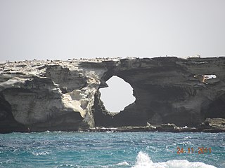
Ilhéu de Sal Rei is an uninhabited islet near the coast of Boa Vista Island, Cape Verde. It is located 1 km southwest of the island capital Sal Rei. Its area is 89 ha (0.34 sq mi) and its highest point is 27 m (88.6 ft).
Praia de Chaves is a beach in the western part of the island of Boa Vista in Cape Verde, close to the town Rabil. It is about 5 km long.
Praia de Santa Mónica is a sandy beach in the southwestern part of the island of Boa Vista in Cape Verde. The nearest village is Povoação Velha, 5 km to the north. The beach is adjacent to the protected area Morro de Areia Nature Reserve, which is important for endemic birds and turtles. Praia de Santa Mónica is part of a tourism development zone.

Praia das Gatas is a sandy beach in the northeastern part of the island of Boa Vista in Cape Verde. The nearest village is Fundo das Figueiras, 5 km to the southwest. It forms a part of Northern Nature Park. The small island Ilhéu dos Pássaros lies off the coast at the Praia das Gatas.
Ponta do Sol is a headland located in the northwest of the island of Boa Vista. Cape Verde. It is the island's northernmost point. The town Sal Rei is approximately 6 km (3.7 mi) to the south, and the hill Vigia is 2 km (1.2 mi) to the south.

Praia de Atalanta is a beach on the north coast of the island of Boa Vista in Cape Verde. It is approximately 6 km northeast of the island capital of Sal Rei and 3 km west of Vigía. The wreck of the Spanish cargo ship Cabo Santa Maria, which ran aground on September 1, 1968, is located here.

Vigia is a low mountain in the northwestern part of the island of Boa Vista, Cape Verde. Its elevation is 146 m. It is situated 4 km north of the island capital Sal Rei, and 2 km south of the headland Ponta do Sol. It is part of the Ponta do Sol Nature Reserve covering 467 hectares of land and sea.

The Deserto de Viana is a sand desert in the northwestern part of the island of Boa Vista, Cape Verde. It is situated east of the towns Rabil and Sal Rei, and west of Bofarreira. The desert itself is not a protected area, but it is adjacent to the nature reserve Boa Esperança, which includes the Lagoa do Rabil and the Praia de Atalanta.
Ponta Varandinha is a headland and the westernmost point of the island of Boa Vista, Cape Verde. To its north lies the beach Praia da Varandinha. The nearest village is Povoação Velha, 5 km to the east. There is a lighthouse on the cape. Its focal height is 22 meters and its range extends to 10 nautical miles.
Morro Negro is a hill located near the east coast of the island of Boa Vista, Cape Verde. Its elevation is 156 m. The nearest village is Cabeça dos Tarrafes, 5.5 km to the northwest.

Povoação Velha is a village in the southwestern part of the island of Boa Vista, Cape Verde. The village is around 16 km south of the island capital Sal Rei.
The Ilhéu de Curral Velho and adjacent coast Important Bird Area lies in the southeastern part of the island of Boa Vista in the Cape Verde archipelago off the coast of north-west Africa in the Atlantic Ocean. It is a 986 ha site consisting of the Ilhéu de Curral Velho, as well as the area opposite it on Boa Vista centred on the deserted village of Curral Velho. It was designated as a Ramsar wetland of international importance on July 18, 2005.
The 2016 Cape Verdean Football Championship season was the 37th beginner level competition of the first-tier football in Cape Verde. It started on 14 May and finished on 9 July, it started five days later than last season and finished two days earlier, the season was a week shorter than last. The championship was governed by the Cape Verdean Football Federation. The scheduling was completed on November 16 and the group system was kept instead of becoming a one portion season without playoffs and was the last time. CS Mindelense won the record breaking title and became the second club after Sporting Praia to win four in a row, the highest ever, also it was Mindelense's last. Mindelense chose to not participate in the CAF Champions League competition in 2017, Académica do Porto Novo did not participate in the 2017 CAF Confederation Cup, both of the clubs due to financial concerns, of any club, it is the eighth consecutive time and becomes the recent African nation not to bring a champion to the continentals for the most consecutive years, in the cup competition, Cape Verde is the longest for not bringing a club in Africa lasting for more than 15 years straight, not even the three national cup winners competed. Mindelense qualified and participated in the 2017 National Championships.
Rocha Estância is a mountain in the southwestern part of the island Boa Vista in Cape Verde, east of the village of Povoação Velha. Its elevation is 357 meters. It is part of a protected area covering 253 ha. The Our Lady of Conception church is located at the western foot of the mountain.

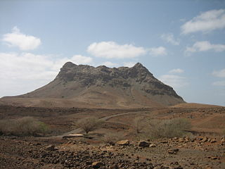
Monte Santo António is a mountain in the southwestern part of the island Boa Vista in Cape Verde. At 379 m (1,243 ft) elevation, it is the island's second highest point. Like Rocha Estância and Monte Estância, it rises steeply from the surrounding plains. It is part of a protected natural area under the statute of natural monument, covering 459 hectares.

Ervatão or Porto de Ervatão is a beach on the southeast coast of the island of Boa Vista in Cape Verde. At its eastern end is the headland Ponta de Ervatão. Ervatão is part of the Turtle Nature Reserve. The area of Ervatão receives 70% of all turtles nesting on Boa Vista. In July 2009, 8,000 turtle nests were counted.
Monte Caçador and Pico Forcado Protected Countryside is a protected area covering 3,357 hectares (12.96 sq mi) of land in the eastern part of the island of Boa Vista in Cape Verde. It is the most important mountain formation on the island, but not the highest.

Morro de Areia Nature Reserve is a nature reserve covering the southwestern coast of the island of Boa Vista in Cape Verde. It takes its name from the hill Morro de Areia, 167 m (548 ft) elevation. The natural reserve covers 21.31 km2 of land area, and stretches along the coast from the Praia de Chaves in the north to the Praia de Santa Monica in the south. The reserve includes a 300 m wide marine protection zone, an additional 4.36 km2.

Praia de Carquejinha is a beach on the south coast of the island of Boa Vista in Cape Verde Neighboring beaches are Praia de Santa Mónica to the west and Praia de Curral Velho to the east. The beach is about 8 km long.


