Maio is the easternmost of the Sotavento islands of Cape Verde. Maio is located south of the island of Boa Vista and east of Santiago. Administratively, the island forms one concelho (municipality): Maio.
Ribeira, Portuguese and Galician for stream or riverside, may refer to the following places:

Tarrafal is a concelho (municipality) of Cape Verde. It is situated in the northern part of the island of Santiago. Its seat is the town Tarrafal. Its population was 18,565 at the 2010 census, and its area is 120.8 km2.
Pedra Badejo is a city in the eastern part of the island of Santiago, Cape Verde. It is situated on the east coast, 25 km north of the island capital Praia, 8 km southeast of Calheta de São Miguel and 15 km east of Assomada. It is the seat of Santa Cruz municipality. At the 2010 census, the town had 9,859 inhabitants.

Tope de Coroa is a mountain on the island of Santo Antão's, Cape Verde. At 1,979 m elevation, it is the highest point of the island. It is in the western part of the island, 25 km west of the island capital Porto Novo. The mountain is entirely of volcanic origin. The area is the source of several streams including Ribeira de Monte Trigo which flows westward to Monte Trigo.

Rabil is a town on the island of Boa Vista, Cape Verde. It was the island's former capital. Rabil is the island's second largest town, located 6 kilometres (3.7 mi) southeast of the island capital of Sal Rei. Its population was 1,248 in 2010. The island's airport, Aristides Pereira International Airport, is situated northwest of the town.

Achada Fazenda is a settlement in the eastern part of the island of Santiago, Cape Verde. In 2010 its population was 2,592. It is situated near the east coast, 2 km southeast of Pedra Badejo, near the estuary of the Ribeira Seca.
Santa Isabel is a freguesia of Cape Verde. It covers the western part of the island of Boa Vista, and contains the island's capital Sal Rei. The freguesia consists of the following settlements:
São João Baptista is a freguesia of Cape Verde. It covers the larger, southern part of the municipality of Porto Novo, on the island of Santo Antão.

Praia de Chaves is a beach in the western part of the island of Boa Vista in Cape Verde, close to the town Rabil. It is about 5 km long.

Estância de Baixo is a settlement in the western part of the island of Boa Vista, Cape Verde. Its population was 578 in 2010, making it the island's third most populated place. The village is around 6 km southeast of the island capital of Sal Rei, west of the Deserto de Viana, on the eastern bank of Ribeira do Rabil.

The Deserto de Viana is a sand desert in the northwestern part of the island of Boa Vista, Cape Verde. It is situated east of the towns Rabil and Sal Rei, and west of Bofarreira. The desert itself is not a protected area, but it is adjacent to the nature reserve Boa Esperança, which includes the Lagoa do Rabil and the Praia de Atalanta.
Várzea Alegre is a municipality in the state of Ceará in the Northeast region of Brazil. Its area is 835.706 km2, including the Calabaça (pumpkin), Canindezinho, Ibicatu, Naraniú and Lagoa Verde districts.

The Lagoa do Rabil is a wetland site in the Cape Verde archipelago, on the island of Boa Vista. It has been recognised as a wetland of international importance by designation under the Ramsar Convention since 2005. The site lies at the mouth of the seasonally flowing Ribeira do Rabil, near the town of Rabil on the west coast of Boa Vista. The site comprises the river mouth, the associated lagoon, the surrounding dunes system and its vegetation dominated by Tamarix, Cyperus, Zygophyllum and Euphorbia species. The site supports a population of Iago sparrows and several species of waders, including Eurasian spoonbill. The endemic lizards Hemidactylus bouvieri and Chioninia stangeri are present.
Lagoa is a settlement in the central part of the island of Santo Antão, Cape Verde. In 2010 its population was 358. It is situated at about 1,200 m elevation on the eastern plateau of Santo Antão, 11 km northwest of the island capital Porto Novo. The Moroços Natural Park lies about 3 km west of Lagoa.
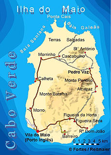
Lagoa Cimidor is a small coastal lagoon in the southeastern part of the island of Maio in Cape Verde. It is situated 3.5 km northeast of the village Ribeira Dom João and 13 km east of the island capital Cidade do Maio. It is part of a 3.89 km2 (1.50 sq mi) protected area which also includes the adjacent coast. One of the largest permanent bodies of water on the island, it is an important area for birds and turtles.

Ribeira Seca is the largest stream of the island of Santiago in Cape Verde. It is 18 km (11 mi) long and its basin area is 71.5 km2 (27.6 sq mi). Located in the eastern part of the island, it flows through the municipalities of São Lourenço dos Órgãos and Santa Cruz. Its source is near the highest point of the island, Pico de Antónia, from where it flows to the east to João Teves. It turns to the northeast and flows into the Atlantic Ocean at Achada Fazenda, 2 km southeast of Pedra Badejo. It is called Ribeira de Pico da Antónia in its uppermost part, and Ribeira de Lage near João Teves.


