Povoação Velha

Last updated
Povoação Velha
Settlement
Rua de Povoacao Velha.jpg
Cape Verde location map.svg
Red pog.svg
Povoação Velha
Coordinates: 16°02′17″N22°55′01″W / 16.038°N 22.917°W / 16.038; -22.917 Coordinates: 16°02′17″N22°55′01″W / 16.038°N 22.917°W / 16.038; -22.917
Country Cape Verde
Island Boa Vista
Municipality Boa Vista
Civil parish Santa Isabel
Elevation 62 m (203 ft)
Population (2010) [1]
  Total 309
Postal code5111

Povoação Velha is a village in the southwestern part of the island of Boa Vista, Cape Verde. [2] [3] The village is around 16 km south of the island capital Sal Rei.

Boa Vista, Cape Verde Cape Verde island

Boa Vista, also written as Boavista, is a desert-like island that belongs to the Cape Verde Islands. At 631.1 km2 (243.7 sq mi), it is the third largest island of the Cape Verde archipelago.

Cape Verde Country comprising ten islands off the Northwest coast of Africa

Cape Verde or Cabo Verde, officially the Republic of Cabo Verde, is an island country spanning an archipelago of 10 volcanic islands in the central Atlantic Ocean. It forms part of the Macaronesia ecoregion, along with the Azores, Canary Islands, Madeira, and the Savage Isles. In ancient times these islands were referred to as "the Islands of the Blessed" or the "Fortunate Isles". Located 570 kilometres (350 mi) west of the Cape Verde Peninsula off the coast of Northwest Africa, the islands cover a combined area of slightly over 4,000 square kilometres (1,500 sq mi).

Sal Rei Settlement in Boa Vista, Cape Verde

Sal Rei is a city on the northwestern coast of the island of Boa Vista in eastern Cape Verde. Sal Rei is the island's main urban settlement, and the seat of the Boa Vista Municipality. In 2010 its population was 5,778. The name of the settlement means "Salt King" in Portuguese. This name stems from when the island's main industry was salt production.

Contents

Geography

Praceta de Santo Antonio, in Povoacao Velha. Povoacao Velha 1.jpg
Praceta de Santo António, in Povoação Velha.

Povoação Velha is situated at the foot of the 357 m high Rocha Estância. [4] To its south is Ribeira Baixa which flows south to the Atlantic. The sandy beach Praia de Santa Mónica lies near the mouth of Ribeira Baixa. Landmarks include the Chapel of Santo António (Saint Anthony) built in 1800, [5] the church of Nossa Senhora da Conceição built in 1828 [6] and Praceta de Santo António in the center. There is a health center in the village [7] and a youth center. [8]

Rocha Estância mountain in Cape Verde

Rocha Estância is a mountain in the southwestern part of the island Boa Vista in Cape Verde, east of the village of Povoação Velha. Its elevation is 357 meters. It is part of a protected area covering 253 ha. The Our Lady of Conception church is located at the western foot of the mountain.

Atlantic Ocean Ocean between Europe, Africa and the Americas

The Atlantic Ocean is the second largest of the world's oceans, with an area of about 106,460,000 square kilometers. It covers approximately 20 percent of the Earth's surface and about 29 percent of its water surface area. It separates the "Old World" from the "New World".

Praia de Santa Mónica

Praia de Santa Mónica is a sandy beach in the southwestern part of the island of Boa Vista in Cape Verde. The nearest village is Povoação Velha, 5 km to the north. The beach is adjacent to the protected area Morro de Areia Nature Reserve, which is important for endemic birds and turtles. Praia de Santa Mónica is part of a tourism development zone.

History

The community is the oldest settlement in the island (hence the name, which means "old settlement"), dating back to the late 16th century. Until 1810, it was the island capital. [2] The 2010 census recorded 309 inhabitants. Hurricane Fred struck Boa Vista island in 2015, damaging 50 houses. [9] [10]

Hurricane Fred (2015) 2015 hurricane

Hurricane Fred was the easternmost Atlantic hurricane to form in the tropics, and the first to move through Cape Verde since 1892. The second hurricane and sixth named storm of the 2015 Atlantic hurricane season, Fred originated from a well-defined tropical wave over West Africa in late August 2015. Once offshore, the wave moved northwestward within a favorable tropospheric environment and strengthened into a tropical storm on August 30. The following day, Fred grew to a Category 1 hurricane with peak winds of 85 mph (140 km/h) as it approached Cape Verde. After passing Boa Vista and moving away from Santo Antão, it entered a phase of steady weakening, dropping below hurricane status by September 1. Fred then turned to the west-northwest, enduring increasingly hostile wind shear, but maintained its status as a tropical cyclone despite repeated forecasts of imminent dissipation. It fluctuated between minimal tropical storm and tropical depression strength through September 4–5. Curving sharply to the north, Fred's circulation pattern had diminished considerably by September 6, and the storm dissipated later that day.

See also

Related Research Articles

Ribeira Grande, Azores Municipality in Azores, Portugal

Ribeira Grande is a municipality in the northern part of the island of São Miguel in the Portuguese Azores. The population in 2011 was 32,112, in an area of 180.15 km². The municipal seat is located in the civil parish of Matriz, with a population of about 4000 inhabitants, part of the urbanized core of what is commonly referred to as the city of Ribeira Grande.

Cidade Velha Settlement in Santiago, Cape Verde

Cidade Velha is a city in the southern part of the island of Santiago, Cape Verde. Founded in 1462, it is the oldest settlement in Cape Verde and its former capital. Once called Ribeira Grande, its name was changed to Cidade Velha in the late 18th century. It is the seat of the Ribeira Grande de Santiago municipality.

Nossa Senhora may refer to the following places:

Santo Antão, Cape Verde Westernmost and largest of the Barlavento islands of Cape Verde

Santo Antão is the westernmost island of Cape Verde. At 779 km2 (301 sq mi), it is the largest of the Barlavento Islands group, and the second largest island of Cape Verde. The nearest island is São Vicente to the southeast, separated by the sea channel Canal de São Vicente. Its population was 40,547 in 2015, making it the third most populous island of Cape Verde after Santiago and São Vicente. Its largest city is Porto Novo on the south coast.

São Nicolau, Cape Verde island of Cape Verde

São Nicolau is one of the Barlavento (Windward) islands of Cape Verde. It is located between the islands of Santa Luzia and Sal. Its population is 12,424 (2015), with an area of 343 km². The main towns are Ribeira Brava and Tarrafal de São Nicolau.

Santiago, Cape Verde largest island of Cape Verde

Santiago is the largest island of Cape Verde, its most important agricultural centre and home to half the nation’s population. Part of the Sotavento Islands, it lies between the islands of Maio and Fogo. It was the first of the islands to be settled: the town of Ribeira Grande was founded in 1462. Santiago is home to the nation's capital city of Praia.

Rabil Settlement in Boa Vista, Cape Verde

Rabil is a town on the island of Boa Vista, Cape Verde. It was the island's former capital. Rabil is the island's second largest town, located 6 kilometres (3.7 mi) southeast of the island capital of Sal Rei. Its population was 1,248 in 2010. The island's airport, Aristides Pereira International Airport, is situated northwest of the town.

Santa Isabel (Boa Vista) Civil parish in Boa Vista, Cape Verde

Santa Isabel is a freguesia of Cape Verde. It covers the western part of the island of Boa Vista, and contains the island's capital Sal Rei. The freguesia consists of the following settlements:

Ribeira Grande, Cape Verde Settlement in Santo Antão, Cape Verde

Ribeira Grande is the largest town of the Ribeira Grande Municipality on the island of Santo Antão, Cape Verde. It has become a city in 2010. In 2010 its population was 2,564. It is situated in the northeastern part of the island, near the outflow of the river Ribeira Grande and its tributary Ribeira da Torre into the Atlantic Ocean. Neighborhoods include Tarrafal, Rua de Agua, Rua d'Horta and Penha de França.

Pro-Cathedral of Our Lady of Grace, Praia Church in Praia, Cape Verde

The Pro-Cathedral of Our Lady of Grace is a catholic church on the east side of Praça Alexandre Albuquerque, in the city centre of Praia, on the island of Santiago, Cape Verde. The church was built between 1894 and 1902. It is the seat of the Roman Catholic Diocese of Santiago de Cabo Verde, which was created in 1533. It is under the pastoral responsibility of Arlindo Gomes Furtado Cardinal.

Plateau (Praia) Neighbourhood in Praia, Santiago Island, Cape Verde

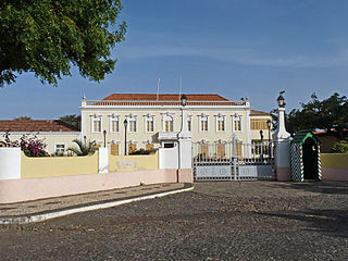
Plateau is the historic centre of the capital city of Praia in the island of Santiago, Cape Verde. It gets its name because it is situated on a plateau overlooking the port of Praia. Its average elevation is 37 meters above sea level. The population of Plateau was 1,019 at the 2010 census. Many public buildings are situated in Plateau, notably the Presidential Palace, the cathedral, the city hall and the Ethnographic Museum.

Praia Harbor

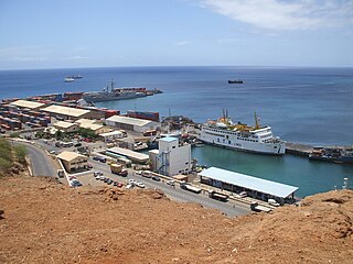
Praia Harbor is the port of the city of Praia in the southern part of the island of Santiago, Cape Verde. It is situated in a natural bay of the Atlantic Ocean. Since the latest modernization in 2014, it has 2 long quays, 3 shorter quays, a quay for fishing boats with fish processing installations, 2 container parks, 2 roll-on/roll-off ramps and a passenger terminal. The total length of the quays is 863 m, and the maximum depth is 13.5 m. The port of Praia played an important role in the colonization of Africa and South America by the Portuguese. With 817,845 metric tonnes of cargo and 85,518 passengers handled (2017), it is the second busiest port of Cape Verde, after Porto Grande (Mindelo).

The following is a timeline of the city of Praia, capital of Cape Verde.

Architecture of Cape Verde

The Architecture of Cape Verde has different architectural styles in the nation. Unlike the African mainland, Cape Verde was uninhabited until 1461 when the Portuguese arrived, most of the other islands were first inhabited after the end of the 15th century. Its architecture was introduced in the 1460s and has its first origins from Portuguese settlers from the Madeira Islands, after the first arrival of mainland Africans, a bit of African architecture would be elements mainly in rural areas. The Manueline was its first architectural style on the island, it was later followed by Renaissance, Baroque, Pombaline, Early Modern and Modern. It was one of the last in the whole of Africa to introduce architecture late. Cape Verde has one of the richest architecture in the western portion of West Africa, the sub-Saharan portion, the richest probably being Mali.

Nossa Senhora da Conceição church (Boa Vista) Church in Boa Vista Island, Cape Verde

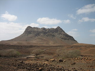
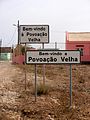
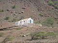
Nossa Senhora da Conceição church is a church at the southeastern edge of the village Povoação Velha, on the island of Boa Vista, Cape Verde. It sits at the foot of the mountain Rocha Estância.

References

  1. "2010 Census results". Instituto Nacional de Estatística Cabo Verde (in Portuguese). 24 November 2016.
  2. 1 2 Patrimonio cultural, Municipality of Boa Vista
  3. Boa Vista Island at SDTIBM (in Portuguese)
  4. Protected areas in the island of Boa Vista - Municipality of Boa Vista, March 2013 (in Portuguese)
  5. Arquipélagos arquipelagos.pt, accessed on 3 February 2017
  6. Cape Verde: Island of Boa Vista at capeverde.com
  7. Ministério da Saúde de Cabo Verde, Relatório Estatístico, 2005, Cape Verdean Ministry of Health, 2006, accessed on 2 February 2017
  8. "«Boa Vista: CEJ da Povoação Velha reabriu este fim de semana - Primeiro diário caboverdiano em linha". A Semana (in Portuguese). 2006. Retrieved 2 February 2017.
  9. Fonseca, Sanny (2015-09-04). "Boa Vista: Hurricane Fred damaged around 50 houses in Povoação Velha". A Semana. Retrieved 2015-09-09.
  10. "Boa Vista: Recuperação de habitações de povoações velha danificadas pelo furacão Fred orçada em 3 mil contos" (Video) (in Portuguese). Praia, Cape Verde: Radiotelevisão Caboverdiana. 2015-09-19. Retrieved 2015-09-23.